
Geomorphological structure monitoring system

Active Publication Date: 2019-03-07
NAT APPLIED RES LAB
View PDF0 Cites 6 Cited by
  • Summary
  • Abstract
  • Description
  • Claims
  • Application Information

AI Technical Summary

Benefits of technology

The geomorphological structure monitoring system has a counterweight unit at the end of the transmission device. This unit helps keep the sensing devices aligned vertically and at the same depths in the water flow. The technical effect of this is that it ensures accurate measurement of the system's performance.

Problems solved by technology

When heavy rain or typhoon strikes, sudden floods will scour the riverbed and causing problems such as earth flow or hillside sliding under the geographical environments such as unstable climate, fast-flowing rivers, or undulating terrain coupled with human factors such as overexploitation of land.
In particular, it poses a serious threat to the structural stability and safety of bridge piers.
However, concerning the safety issue of the inspectors under climates such as heavy rain or typhoon, the scouring condition of the riverbed may not be monitored immediately.
Therefore, warnings may not be issued efficiently and loss of life and property of passers-by may happen.
However, this type of measuring method requires on-site measurement, and the accuracy of the measuring result is easily affected by factors such as siltation so that the real scouring condition of the riverbed cannot be monitored precisely and instantly.
However, the thermometers disposed under the riverbed are easily damaged; thus, it is difficult to monitor the structure of the riverbed correctly.

Method used


Image

  • Geomorphological structure monitoring system
  • Geomorphological structure monitoring system
  • Geomorphological structure monitoring system

Examples


embodiment 1

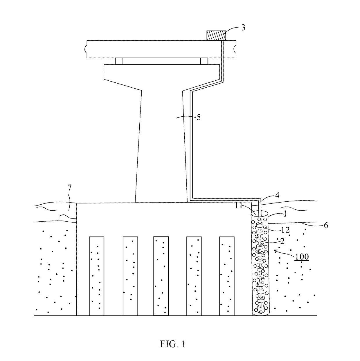
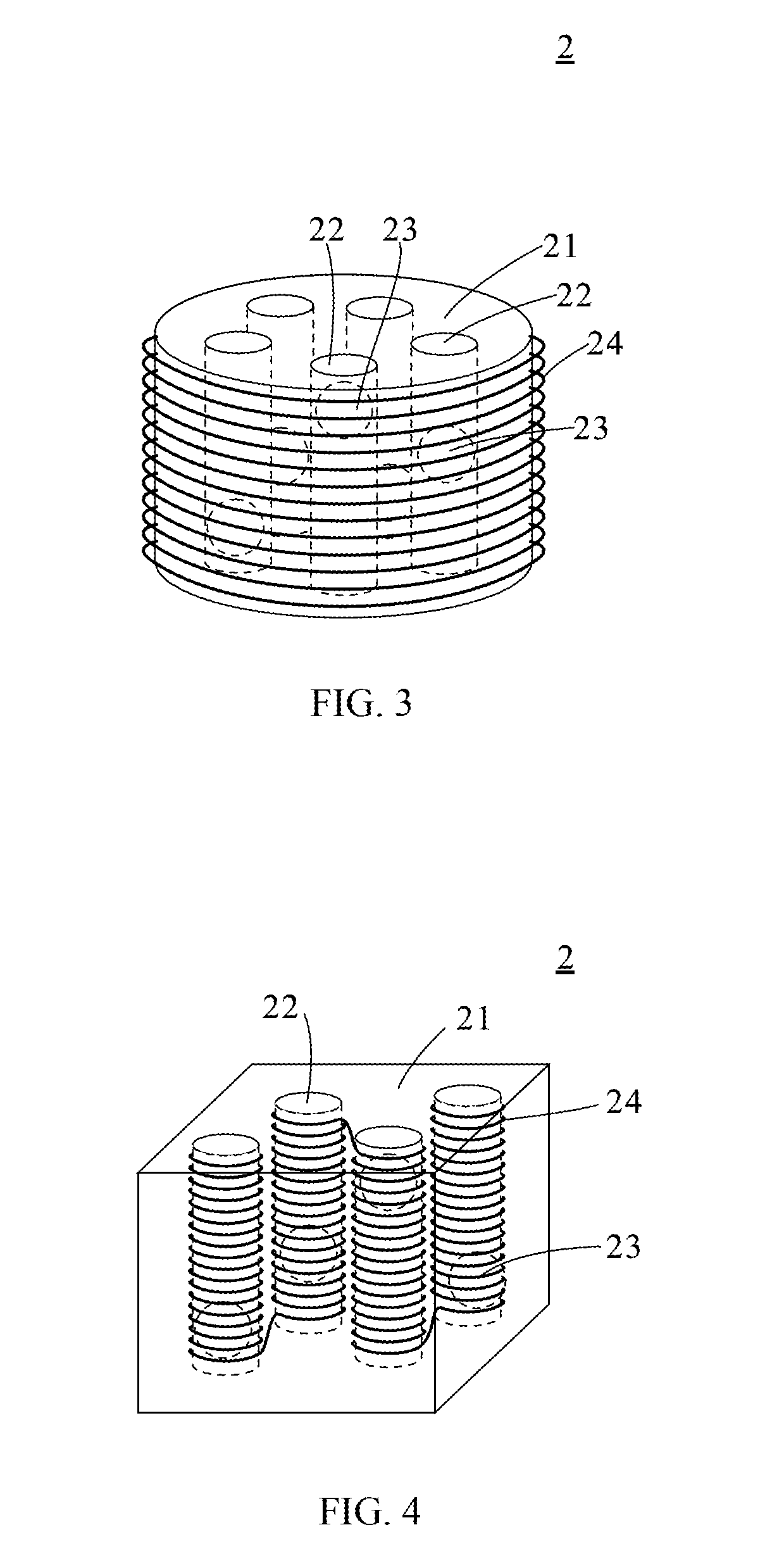
[0028]The geomorphological structure monitoring system is illustrated in FIG. 1. As shown in FIG. 1, the geomorphological structure monitoring system 100 includes a supporting base 1; a plurality of sensing devices 2; a signal processing device 3; and a transmission device 4.

[0029]The supporting base 1 is a hollow shell having an accommodating space 11, wherein a plurality of through holes 12 is formed on the wall of the supporting base 1. The through holes 12 allow the soil of the riverbed 6 or river water to flow in and out of the accommodating space 11. The sensing devices 2 are connected to the signal processing device 4 in intervals, and the signal processing device 4 and the sensing devices 2 are accommodated in the accommodating space 11 of the supporting base 1. The transmission device 4 connects the signal processing device 3, and the transmission device 4 may be disposed on a bridge pier 5.

[0030]The material of the supporting base 1 is not particularly limited, wherein the...

embodiment 2

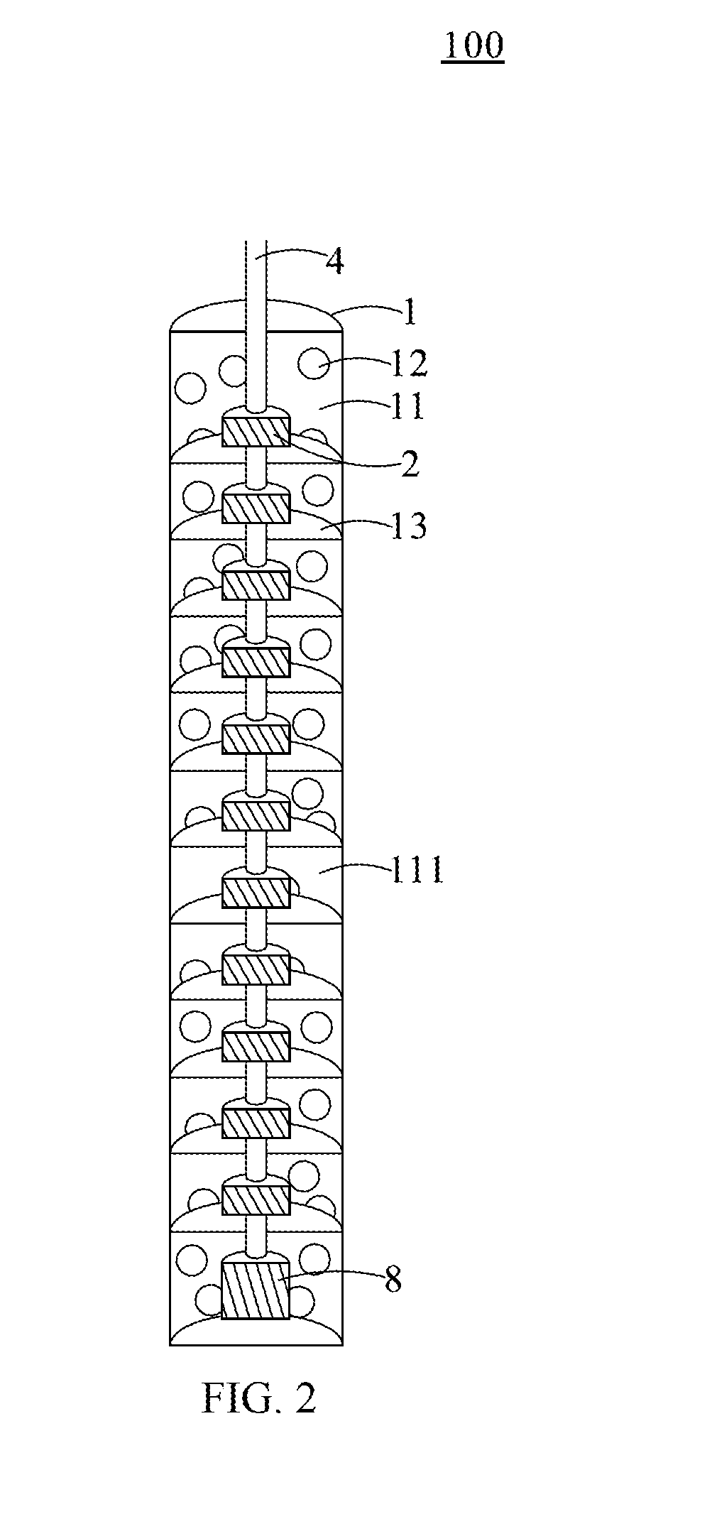
[0039]A geomorphological structure monitoring device 200 provided by another embodiment of the present invention is illustrated in FIG. 5, wherein the geomorphological structure monitoring device 200 comprises a supporting base 1, a plurality of sensing devices 2, a signal processing device 3, a transmission device 4, and a counterweight unit 8.

[0040]The structural features of the supporting base 1, the sensing devices 2, the signal processing device 3, and the transmission device 4 are similar to that in Embodiment 1, for purposes of brevity, any description in Embodiment 1 above is incorporated herein insofar as the same is applicable, and the same description need not be repeated.

[0041]In the present embodiment, the counterweight unit 8 is disposed at an end of the transmission device 4, accommodated in the accommodating space 11 of the supporting base 1, and contacting the riverbed 6. The sensing devices 2 may be towed away by the counterweight unit 8 under the action of gravity...


PUM


Abstract

A geomorphological structure monitoring system is disclosed, which comprises a supporting base having an accommodating space and a plurality of through holes, and at least a portion of the supporting base is embedded under a ground; a plurality of sensing devices arranged in the accommodating space vertically and embedded under the ground, the sensing devices may generate a sensing signal when the sensing devices are exposed from the ground due to the structural change of the ground; a signal processing device receiving and processing the sensing signal; and a transmission device connecting the sensing devices in series and the signal processing device.

Description

CROSS REFERENCE TO RELATED APPLICATION[0001]This application claims the benefits of the Taiwan Patent Application Serial Number 106130258, filed on Sep. 5, 2017, the subject matter of which is incorporated herein by reference.BACKGROUND OF THE INVENTION1. Field of the Invention[0002]The present invention relates to a geomorphological structure monitoring system, particularly, to a geomorphological structure monitoring system for monitoring a scour depth of riverbed or seabed.2. Description of Related Art[0003]When heavy rain or typhoon strikes, sudden floods will scour the riverbed and causing problems such as earth flow or hillside sliding under the geographical environments such as unstable climate, fast-flowing rivers, or undulating terrain coupled with human factors such as overexploitation of land. In particular, it poses a serious threat to the structural stability and safety of bridge piers.[0004]The traditional method for measuring the scour depth of riverbed and the water l...

Claims


Application Information

Patent Timeline
IPC IPC(8): G01V3/10G01C13/00
CPCG01V3/10G01C13/008G01N33/24E02B3/00
Inventor LIN, YUNG-BINLIAO, TAI-SHANCHANG, KUO-CHUN
Owner NAT APPLIED RES LAB
Learn More