
Portable terminal, navigation system, and storage medium storing program

a technology of portability and program, applied in surveying, navigation, instruments, etc., can solve the problems of inability to achieve the navigation function satisfactorily, the device concerned has not been able to obtain sufficient positioning data, and the difficulty in using the portability device concerned, etc., to achieve the effect of simple comparison

Inactive Publication Date: 2012-12-13
CASIO COMPUTER CO LTD
View PDF12 Cites 98 Cited by
  • Summary
  • Abstract
  • Description
  • Claims
  • Application Information

AI Technical Summary

Benefits of technology

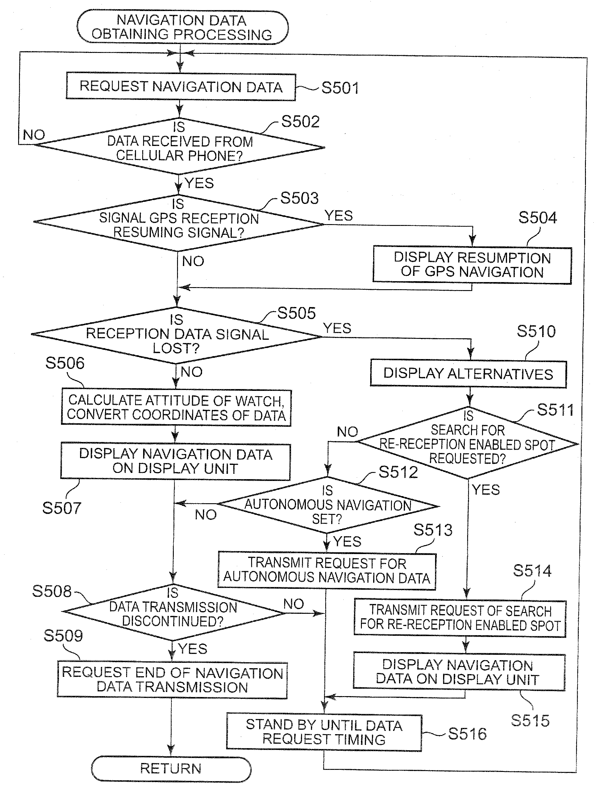
[0015]wherein the control unit (i) allows the display unit to display orientation information included in the navigation data obtained from the wireless communication unit, in accordance with orientation data obtained based on a signal from the detection unit, and (ii) allows the display unit to display navigation data that is simple in comparison with the navigation data displayed by the portable external instrument, the simple navigation data including at least a display in a travelling direction, based on the navigation data obtained from the portable external instrument by the wireless communication unit.
[0018]wherein the control unit executes processing for (i) allowing the display unit to display orientation information included in the navigation data obtained from the wireless communication unit, in accordance with orientation data obtained based on a signal from the detection unit, and (ii) allowing the display unit to display navigation data that is simple in comparison with the navigation data displayed by the portable external instrument, the simple navigation data including at least a display in a travelling direction, based on the navigation data obtained from the portable external instrument by the wireless communication unit.

Problems solved by technology

Hence, in a case where a user who rides a bicycle, a pedestrian who carries baggage, or the like desires to use a navigation device, then the conventional portable navigation device cannot be held easily since there is no free hand, and accordingly, it has sometimes been difficult to use the portable navigation device concerned.
Meanwhile, heretofore, in the navigation device mounted on the watch, it has been difficult to frequently receive the data owing to such a problem of a battery capacity, and accordingly, in some cases, the navigation device concerned has not been able to obtain sufficient positioning data, and has not been able to achieve the navigation function satisfactorily.

Method used


Image

  • Portable terminal, navigation system, and storage medium storing program
  • Portable terminal, navigation system, and storage medium storing program
  • Portable terminal, navigation system, and storage medium storing program

Examples


Embodiment Construction

[0028]A description is made below of a navigation system in an embodiment of the present invention based on the drawings.

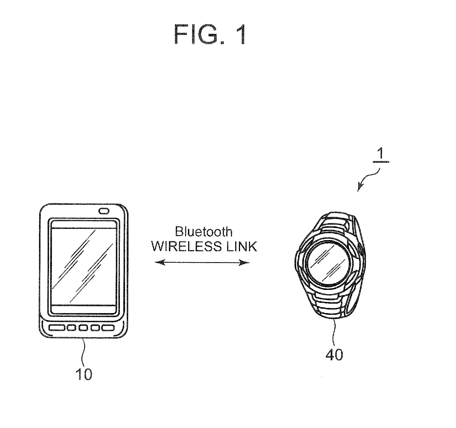
[0029]FIG. 1 is an overall configuration view showing the navigation system of this embodiment.

[0030]The navigation system 1 of this embodiment is composed of: an electronic timepiece 40 as a wrist-attached terminal (portable terminal); and a cellular phone 10 as a portable external instrument. The electronic timepiece 40 is one of a watch type, which includes a watch body and a band, and is attachable to the wrist. The cellular phone 10 includes a wireless communication function to perform wireless communication with a base station, and in addition, a function to receive radio waves from GPS satellites. As a single body, the cellular phone 10 is capable of executing GPS positioning and a navigation operation with regard to a travelling direction of a user. Moreover, each of the electronic timepiece 40 and the cellular phone 10 includes a short-range wireless comm...


PUM


Abstract

A portable terminal includes: a wireless communication unit which performs transmission and reception of data with a portable external instrument by wireless communication; a control unit which requests navigation data from the portable external instrument at a previously set request timing to obtain the navigation data therefrom; a display unit which performs a display based on a control signal from the control unit; and a detection unit which detects an orientation, wherein the control unit (i) allows the display unit to display orientation information included in the navigation data, in accordance with orientation data obtained based on a signal from the detection unit, and (ii) allows the display unit to display navigation data including at least a display in a travelling direction, that is simple in comparison with the navigation data displayed by the portable external instrument, based on the navigation data obtained from the portable external instrument.

Description

CROSS-REFERENCE TO RELATED APPLICATIONS[0001]This application is based upon and claims the benefit of priority from the prior Japanese Patent Application No. 2011-126855, filed on Jun. 7, 2011, the entire contents of which are incorporated herein by reference.BACKGROUND OF THE INVENTION[0002]1. Field of the Invention[0003]The present invention relates to a portable terminal for use in navigation, to a navigation system, and to a storage medium storing a program.[0004]2. Description of Related Art[0005]Heretofore, there has been a navigation device that guides a course of a user to a destination thereof by map data and positioning data obtained by using a satellite-using positioning system such as a global positioning system (GPS). The navigation device as described above includes a portable navigation device usable by a pedestrian.[0006]For example, in Japanese Patent Laid-Open Publication No. 2008-286546, a technology is disclosed, in which, in a watch having a function to receive ...

Claims


Application Information

Patent Timeline
Patent Type & Authority Applications(United States)
IPC IPC(8): G01C21/36
CPCG01C21/3661
Inventor KITTA, NORIYUKI
Owner CASIO COMPUTER CO LTD
Learn More