
Map display apparatus, method, and program

a map display and program technology, applied in surveying and navigation, navigation instruments, instruments, etc., can solve the problems of reducing the necessary memory capacity of the vrams and the difficulty in reducing the processing time for storing image data, so as to reduce the processing time reduce the memory capacity for storing map images

Inactive Publication Date: 2011-09-22
AISIN AW CO LTD
View PDF0 Cites 10 Cited by
  • Summary
  • Abstract
  • Description
  • Claims
  • Application Information

AI Technical Summary

Benefits of technology

[0008]Accordingly, exemplary implementations of the broad inventive principles described herein provide a map display apparatus, a map display method, and a program which allow reduction in necessary processing time for storing a map image and decrease in memory capacity for storing a map image in the case of a scroll operation from which a range of movement can be identified.
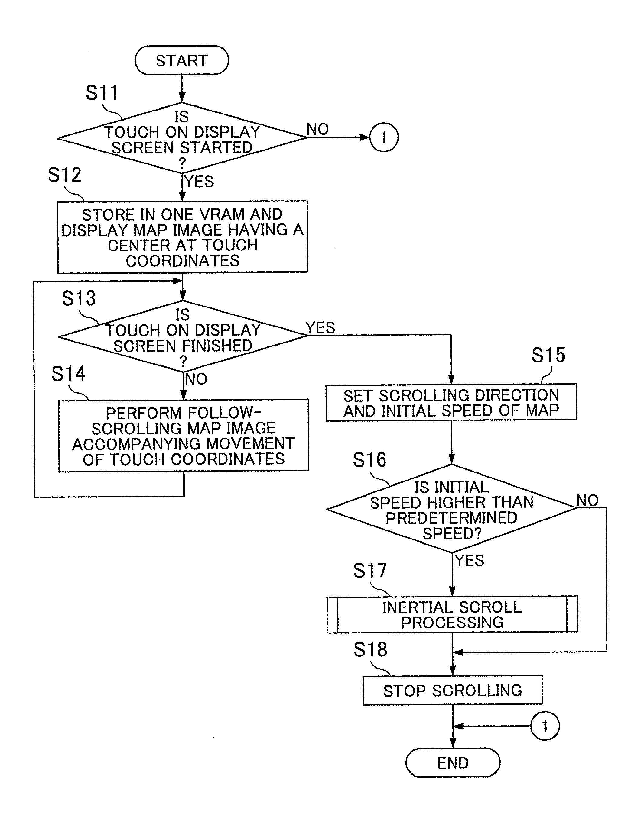
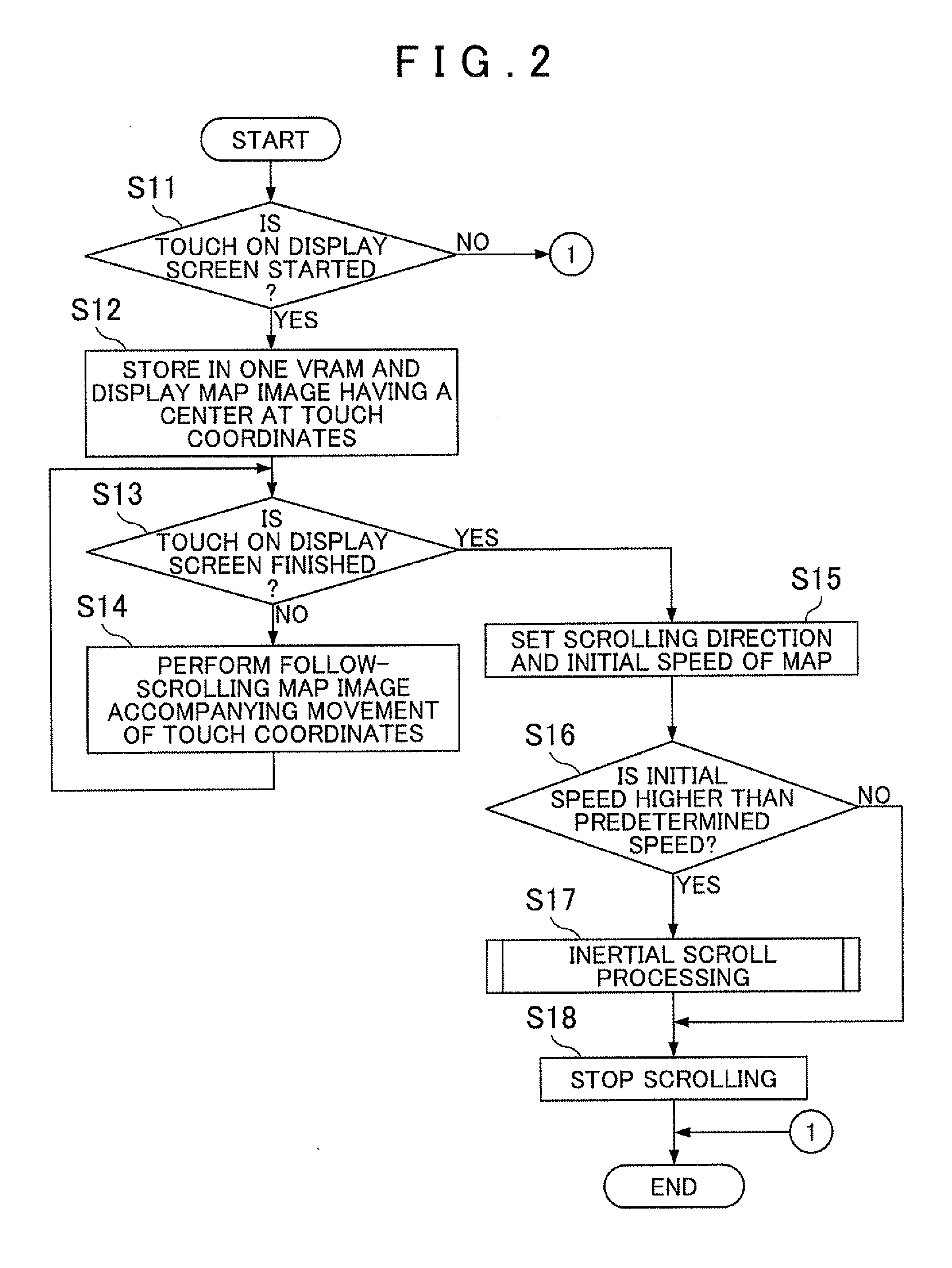
[0009]In exemplary implementations, when follow-scrolling of a map image displayed following the movement of a pressed coordinate position on a display screen is performed, pressed coordinates cannot be moved to the outside of the display screen. Thus, a map image drawn based on map information of an area vertically and horizontally twice as large as the display screen, the area having a center at a position on a map where pressing is detected first, may be stored once in a map image information storage unit. Accordingly, a processing time for storing a map image needed for the follow-scrolling of a map image following the movement of a pressed position on the display screen can be reduced, and a memory capacity for storing the map image can be decreased. By storing the map image drawn based on the map information of an area vertically and horizontally twice as large as the display screen in the map image information storage unit, the follow-scrolling can be performed securely until the pressed position reaches an edge portion of the display screen irrespective of which position on the display screen is pressed first.
[0010]In exemplary implementations, there is stored in the map image information storage unit a map image drawn based on map information obtained such that, to map information of an area vertically and horizontally twice as large as the display screen, the area having a center at a position on a map where the pressing is detected first, map information of an outside predetermined distance area of a peripheral portion of the area is added. Accordingly, even when the area displayed on the display screen reaches the peripheral portion of the area vertically and horizontally twice as large as the display screen, the map image can be displayed securely.
[0011]In exemplary implementations, when inertial scrolling of the map image is performed based on a moving direction and a moving speed of a finger at the time when pressing of the display screen is released, a map image drawn based on map information of an area corresponding to the moving direction of the finger may be stored in the map image information storage unit. Accordingly, a memory capacity for storing map information needed for performing the inertial scrolling of the map image can be decreased. A processing time for storing the map information needed for performing the inertial scrolling of the map image is reduced, and displaying of the inertial scrolling can be performed smoothly.
[0012]In exemplary implementations, when follow-scrolling of a map image displayed following the movement of a pressed coordinate position on a display screen is performed, pressed coordinates cannot be moved to the outside of the display screen. Thus, a map image drawn based on map information of an area vertically and horizontally twice as large as the display screen, the area having a center at a position on a map where pressing is detected first, may be stored once in a map image information storage unit. Accordingly, a processing time for storing a map image needed for the follow-scrolling of a map image following the movement of a pressed position on the display screen can be reduced, and a memory capacity for storing the map image can be decreased. By storing the map image drawn based on the map information of an area vertically and horizontally twice as large as the display screen in the map image information storage unit, the follow-scrolling can be performed securely until the pressed position reaches an edge portion of the display screen irrespective of which position on the display screen is pressed first.
[0013]Further, with a program according to exemplary implementations, in a computer reading this program, when follow-scrolling of a map image displayed following the movement of a pressed coordinate position on a display screen is performed, pressed coordinates cannot be moved to the outside of the display screen. Thus, a map image drawn based on map information of an area vertically and horizontally twice as large as the display screen, the area having a center at a position on a map where pressing is detected first, may be stored once in a map image information storage unit. Accordingly, in the computer, a processing time for storing a map image needed for the follow-scrolling of a map image following movement of a pressed position on the display screen can be reduced, and a memory capacity for storing the map image can be decreased. In the computer, by storing the map image drawn based on the map information of an area vertically and horizontally twice as large as the display screen in the map image information storage unit, the follow-scrolling can be performed securely until the pressed position reaches an edge portion of the display screen irrespective of which position on the display screen is pressed first.

Problems solved by technology

Therefore, there is a problem of difficulty in reducing a processing time for storing the image data and in decreasing necessary memory capacities of the VRAMs.

Method used


Image

  • Map display apparatus, method, and program
  • Map display apparatus, method, and program
  • Map display apparatus, method, and program

Examples


Embodiment Construction

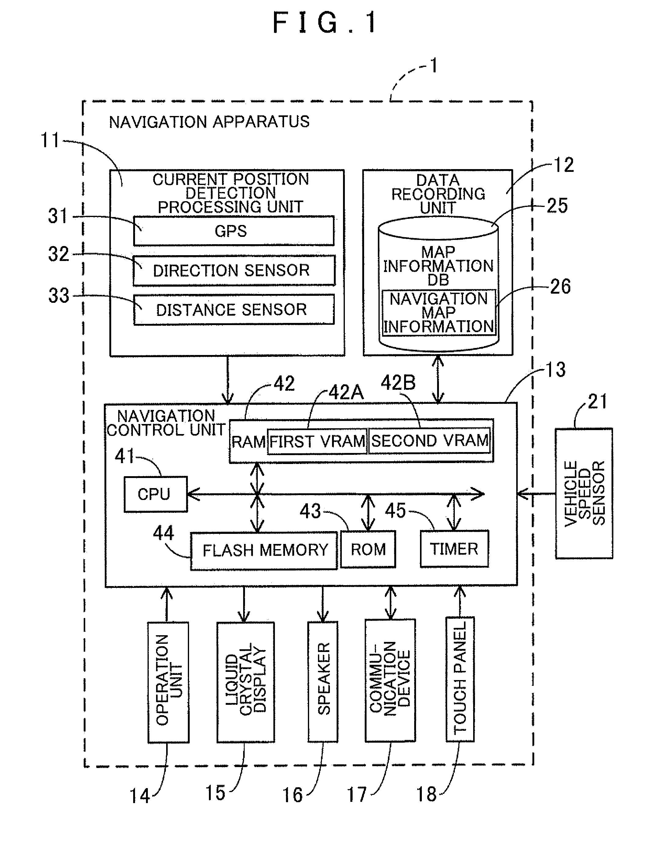
[0019]Hereinafter, a map display apparatus, a map display method and a program will be described in detail with reference to the drawings based on an example which embodies the map display apparatus, the map display method and the program in a navigation apparatus.

[0020]First, a schematic structure of the navigation apparatus according to the example will be described based on FIG. 1. FIG. 1 is a block diagram illustrating a navigation apparatus 1 according to the example.

[0021]As illustrated in FIG. 1, the navigation apparatus 1 according to the example is structured from a current position detection processing unit 11 which detects the current position of a vehicle, or the like, a data recording unit 12 in which various data are recorded, a controller (e.g., navigation control unit 13) which performs various calculation processing based on inputted information, an operation unit 14 which accepts an operation from the operator, a liquid crystal display 15 which displays information...


PUM


Abstract

Map display apparatus, methods, and programs store a first map image drawn based on map information stored in a map information storage unit and cause a partial range of the first map image to be displayed on a display unit. The apparatus, methods, and programs detect a pressed coordinate position where the display unit is pressed. When the pressing of the display screen is detected, the apparatus, methods, and programs cause a second map image drawn based on map information of an area vertically and horizontally twice as large as the display screen to be stored in a map image storage unit. The area has a center at a map position corresponding to the detected coordinate position. The apparatus, methods, and programs perform. follow-scrolling to move a display range of the second map image based on movement of the detected coordinate position.

Description

INCORPORATION BY REFERENCE[0001]The disclosure of Japanese Patent Application No. 2010-058630 filed on Mar. 16, 2010 including the specification, drawings and abstract is incorporated herein by reference in its entirety.BACKGROUND[0002]1. Related Technical Fields[0003]Related technical fields include map display apparatus, methods, and programs for displaying a map on a screen.[0004]2. Related Art[0005]In the related art, various proposals are made with respect to a technique for operation of scrolling a map displayed on a screen.[0006]For example, there are provided two, first and second VRAMs storing image data of an area larger than a display area of a display screen. Map data of a predetermined area are read from a map data storage unit to create image data, and the created image data are stored in one of the VRAMs. An area for reading a map from this VRAM corresponding to the display area of the display screen is set, a scrolling direction by a manual operation is detected, and...

Claims


Application Information

Patent Timeline
Patent Type & Authority Applications(United States)
IPC IPC(8): G06F3/041G09G5/00G06F3/048G06F3/0485
CPCG01C21/367
Inventor USHIDA, KOICHI
Owner AISIN AW CO LTD
Learn More