
Satellite-based positioning receiver

a satellite-based positioning and receiver technology, applied in satellite radio beaconing, measurement devices, instruments, etc., can solve problems such as lack of precision, inability to circumvent system-related errors, and inability to measure pseudo-distance, etc., to achieve the effect of improving the accuracy of results

Inactive Publication Date: 2011-07-28
THALES SA
View PDF5 Cites 23 Cited by
  • Summary
  • Abstract
  • Description
  • Claims
  • Application Information

AI Technical Summary

Benefits of technology

[0032]The invention provides an alternative improving the precision of the results, under vector tracking.
[0033]The invention is based on carrier phase measurements at the output of the signal processing and on the vector slaving of this same phase using a Kalman filter, with or without inertial coupling. The phase measurement is much more precise than the Doppler measurement and therefore allows better quality navigation.
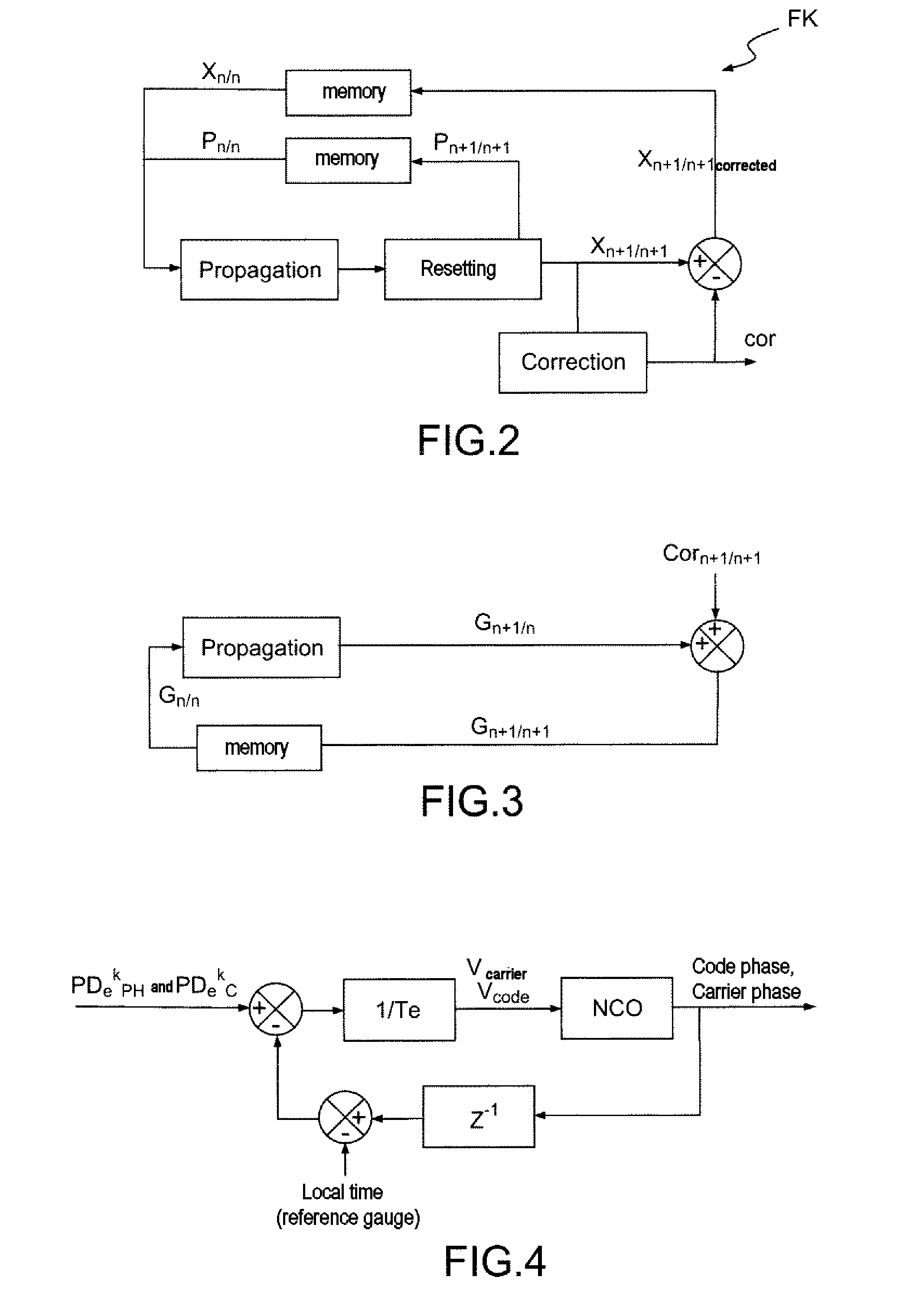
[0044]These slayings make it possible notably to correct the truncation errors of the numerically-controlled oscillators and thus prevent the applied phase from drifting from the controlled phase.
[0053]Thus the estimation of the error related to the propagation of the signal in the ionosphere of each satellite is improved. The precision of the calculated position is therefore better. Moreover, the receiver is more robust to jamming impacting only a single frequency.

Problems solved by technology

The measurement of the pseudo-distance cannot for example circumvent the system-related errors such as the lack of precision of the ephemerides or clocks onboard the satellites.
The measurement of the pseudo-distance is also marred by errors related to the interactions between the signals and the atmospheric layers that they pass through.
In certain applications such as for example a precision approach in aeronautics, the positioning precision obtained by a direct (or absolute) measurement of the pseudo-distance is not sufficient.
However, the differential measurement does not eliminate the errors related to the reflections of the signal on objects that are close to the antenna of the receiver, nor the errors specific to the receiver (thermal noise).
The main benefit of the axis-by-axis smoothing process lies in its simplicity and in the absence of any coupling effect between the measurements of the pseudo-distances of the various satellites or channels, nonetheless it is not completely satisfactory.
The calculation is based on two types of error which are on the one hand normal measurement errors and on the other hand errors caused by an operating anomaly in the constellation of satellites, by a failure of a satellite or else a failure of a ground receiver.
In both cases the consequences can be serious, hence the necessity to minimize the probability of such events.
For example, in the case of existing systems which are based on smoothing, axis by axis, the pseudo-random code position measurements by the phase variations of the carrier, the protection radius degrades abruptly as a satellite disappears and takes a long time to regain an acceptable value after the satellite reappears, because of the response time of the smoothing filter.

Method used


Image

  • Satellite-based positioning receiver
  • Satellite-based positioning receiver
  • Satellite-based positioning receiver

Examples


Embodiment Construction

[0078]In the description that follows, similar elements bear the same reference characters.

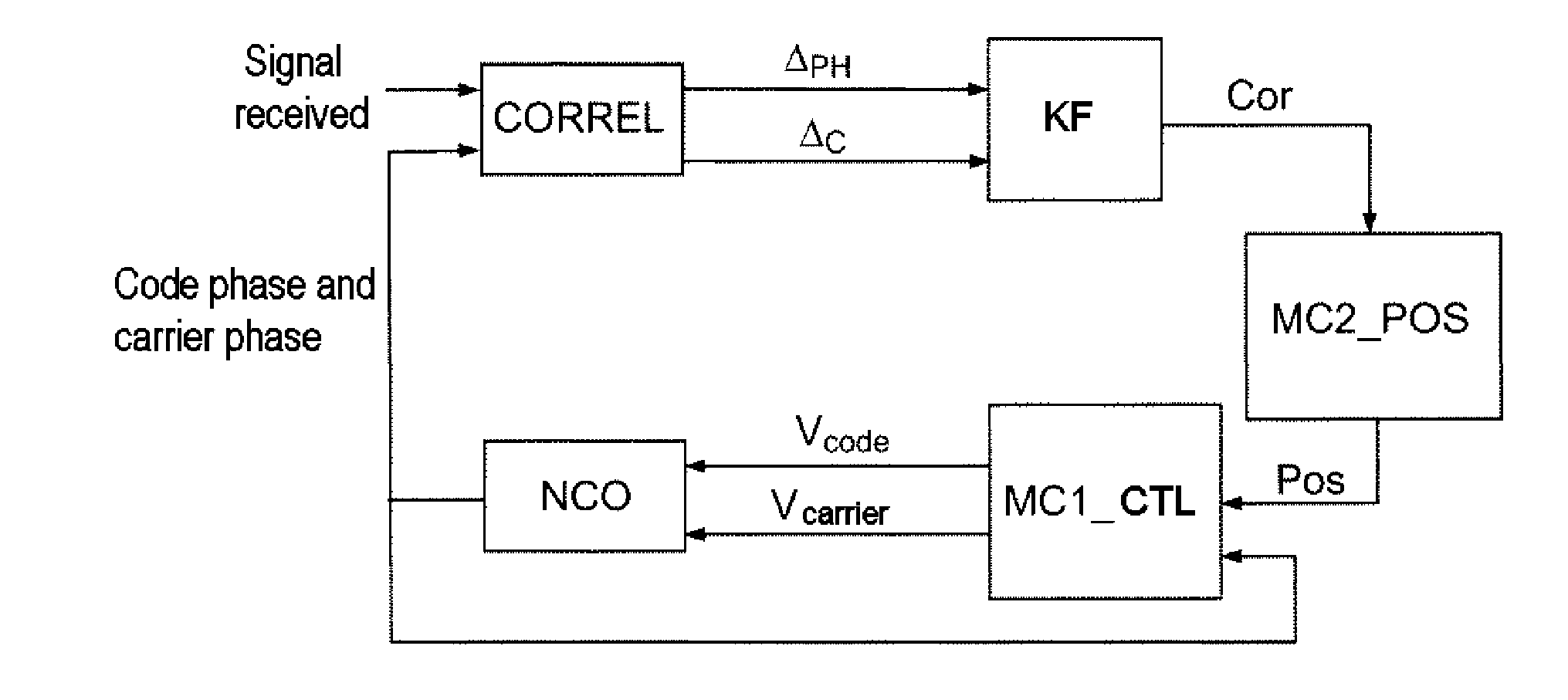
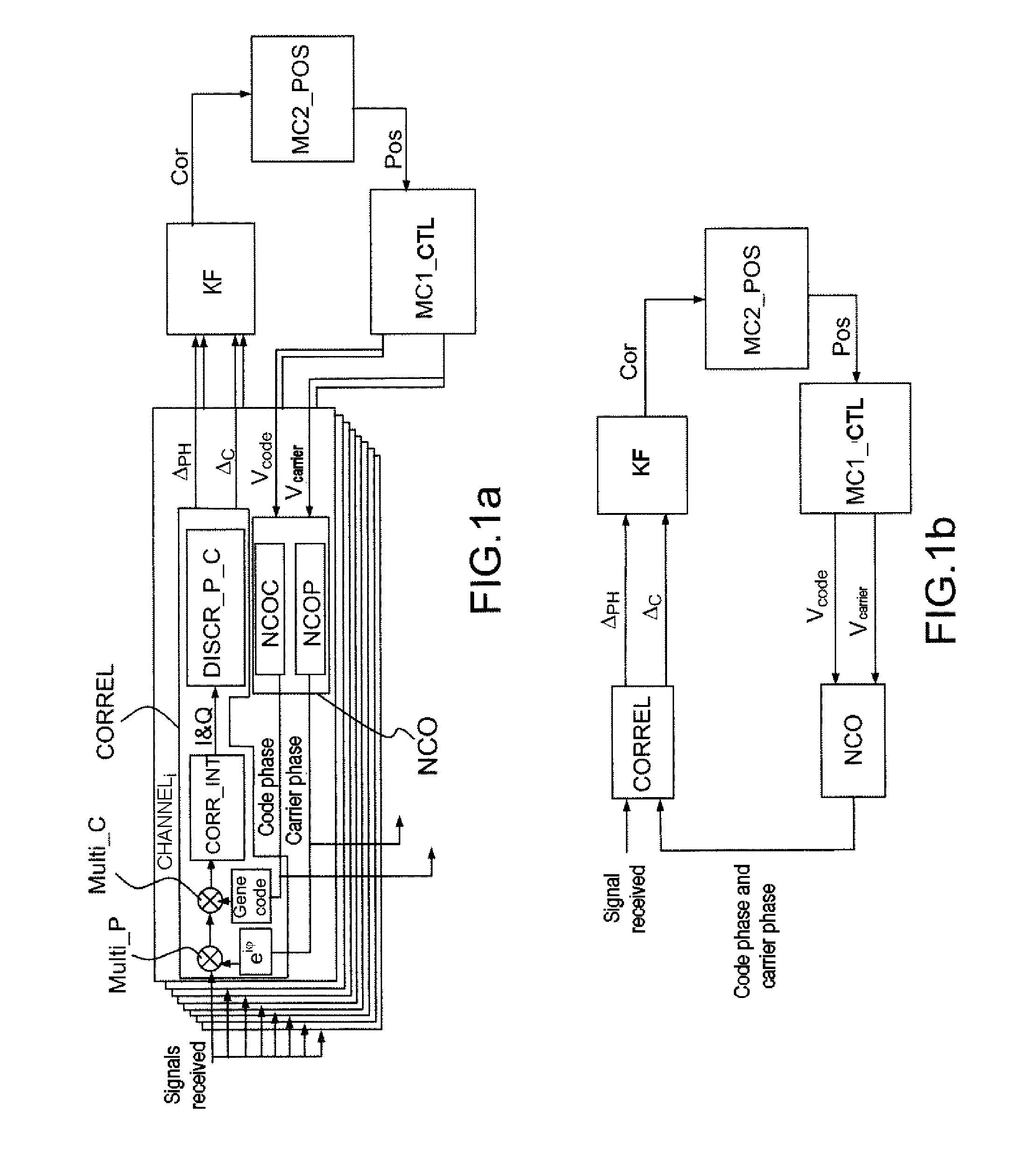
[0079]In FIG. 1a, a satellite-based positioning receiver comprises processing channels CHANNELi, each associated with a respective satellite from among N satellites, an extended Kalman filter KF adapted for performing a vector tracking, for the set of satellites, of the signals received from the N satellites. The extended Kalman filter KF is adapted for performing a propagation of an estimated state vector comprising the said position error, and for implementing a matrix propagation equation involving a propagation matrix.

[0080]Each channel CHANNELi comprises a code generator Genecode, a phase generator eiφ, correlators with integrators CORR_INT, phase and code discriminators DISCR_P_C, a code phase numerically-controlled oscillator NCOC, and a carrier phase numerically-controlled oscillator NCOP. The set formed by the code phase numerically-controlled oscillator NCOC and by the carrier phase ...


PUM


Abstract

A satellite-based positioning receiver includes processing channels, each processing channel being associated with a respective satellite from among N satellites, and an extended Kalman filter for performing a vector tracking for the set of satellites using signals received from the satellites. The extended Kalman filter performs a resetting on the basis of the phase error and code error received directly from the phase and code discriminators, of each channel, and the receiver includes first means for calculating the code-wise and carrier-wise control signals for the said code phase and carrier phase numerically-controlled oscillators, on the basis of data provided by the said extended Kalman filter, for each channel.

Description

CROSS-REFERENCE TO RELATED APPLICATION[0001]This application claims priority to foreign French patent application No. FR 09 06182, filed on Dec. 18, 2009, the disclosure of which is incorporated by reference in its entiretyFIELD OF THE INVENTION[0002]The invention relates to a signal receiver for a satellite-based radionavigation system intended to calculate the position of a carrier very precisely. The best known system, which will be referred to hereinafter, is the GPS system, and satellite-based radionavigation systems will be designated under the generic term GPS even if they are similar systems such as Galileo or Glonass.BACKGROUND OF THE INVENTION[0003]The GPS system uses a constellation of satellites which rotate about the earth in very precisely determined orbits, that is to say the position of an arbitrary satellite can be ascertained at any instant. The orbits of the satellites are chosen in such a way that at any time, 6 to 12 satellites are visible at any point of the ea...

Claims


Application Information

Patent Timeline
IPC IPC(8): G01S19/43G01S19/29G01S19/30
CPCG01S19/43G01S19/24
Inventor CHOPARD, VINCENTMARTIN, NICOLAS
Owner THALES SA
Learn More