System and method for obtaining georeferenced mapping data

a georeferenced mapping and system technology, applied in the direction of distance measurement, navigation instruments, instruments, etc., can solve the problem that none of these patents appear to disclose the gps-denied zone of obtaining three-dimensional data, and achieve the effect of reducing the number of personnel at risk

Inactive Publication Date: 2009-10-22
TRIMBLE NAVIGATION LTD
View PDF14 Cites 224 Cited by
  • Summary
  • Abstract
  • Description
  • Claims
  • Application Information

AI Technical Summary

Benefits of technology

[0014]In an embodiment, an IMS is based on a navigation-grade IMU aided by zero-velocity updates. The IMU is combined with a scanning laser and a digital camera. The system is small and lightweight and can be backpack portable. The aided-inertial system measures the IMS position as well as pitch, roll, heading and the laser measures the distance between the IMS and the laser data points. Combining these measurements provides a detailed map of the details of the surveyed regions of the building. This can be further visually enhanced by combining digital cameral imagery with the laser data points. The resulting photomaps are geo-referenced digital imagery of the surveyed regions, and can be detailed at sub-meter accuracies.
[0015]By providing information to enable a virtual tour of the interior premises, a roving person such as a law enforcement officer or military person can be equipped with a display device, which may be near the eyes, such as a head-up display or a stereo display device, and can walk through the premises and have a virtual tour even if there is no light or if the premises is filled with smoke or the like. The person can be directed by other personnel outside the premises who can be equipped with the same display of the same images observed by the rover to enable such personnel to communicate with and guide the person inside the premises. This can minimize the number of personnel at risk. Alternatively, a robot can be used, guided by outside personnel, which could be maneuvered throughout a desired region of the premises without placing a person at risk.

Problems solved by technology

None of these patents appear to disclose obtaining three-dimensional data in a GPS-denied zone such as indoors, wherein the data includes not only three-dimensional position information, but also characteristic image data information, such as color, brightness, reflectivity and texture of the target surfaces to enable an image display of a virtual tour of an interior region as if the person were actually inside the premises.

Method used


Image

  • System and method for obtaining georeferenced mapping data
  • System and method for obtaining georeferenced mapping data
  • System and method for obtaining georeferenced mapping data

Examples


Embodiment Construction

Definitions

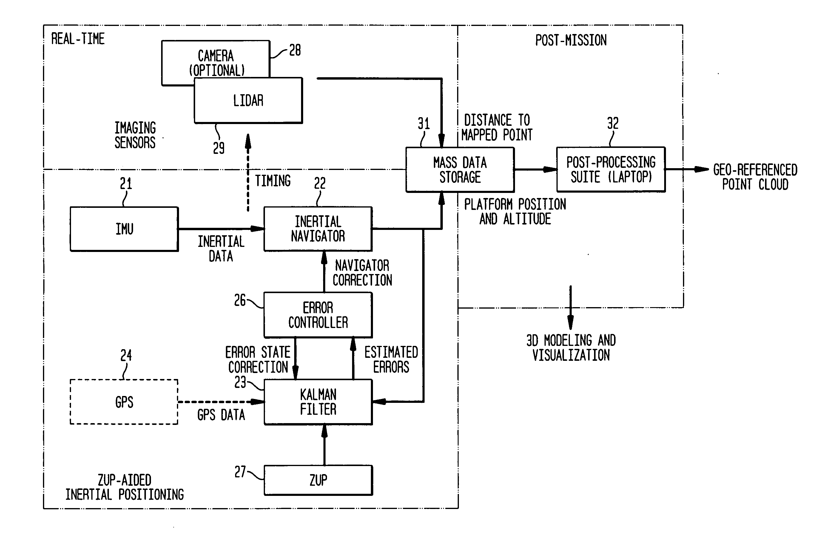
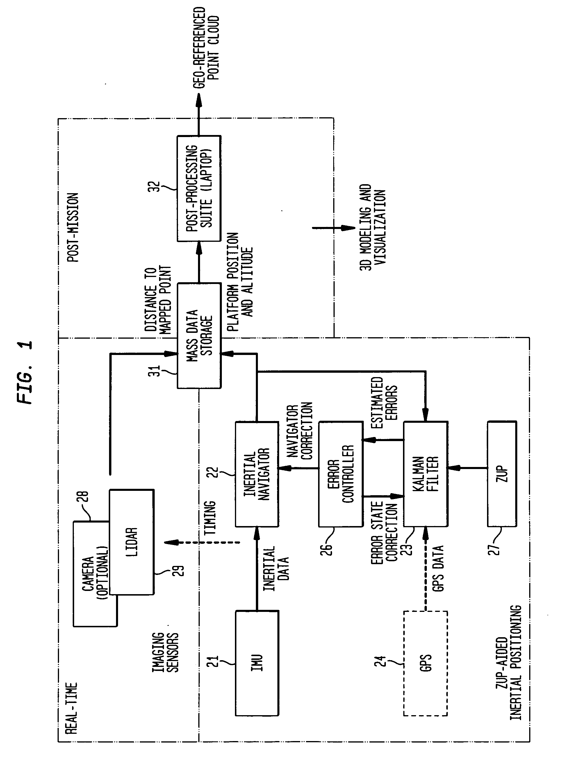
[0025]As used herein, the term “geospatial data” means image and position data for points in space.

[0026]As used herein, the term “georeferencing” means the assigning of geographical coordinates to one or more points in space.

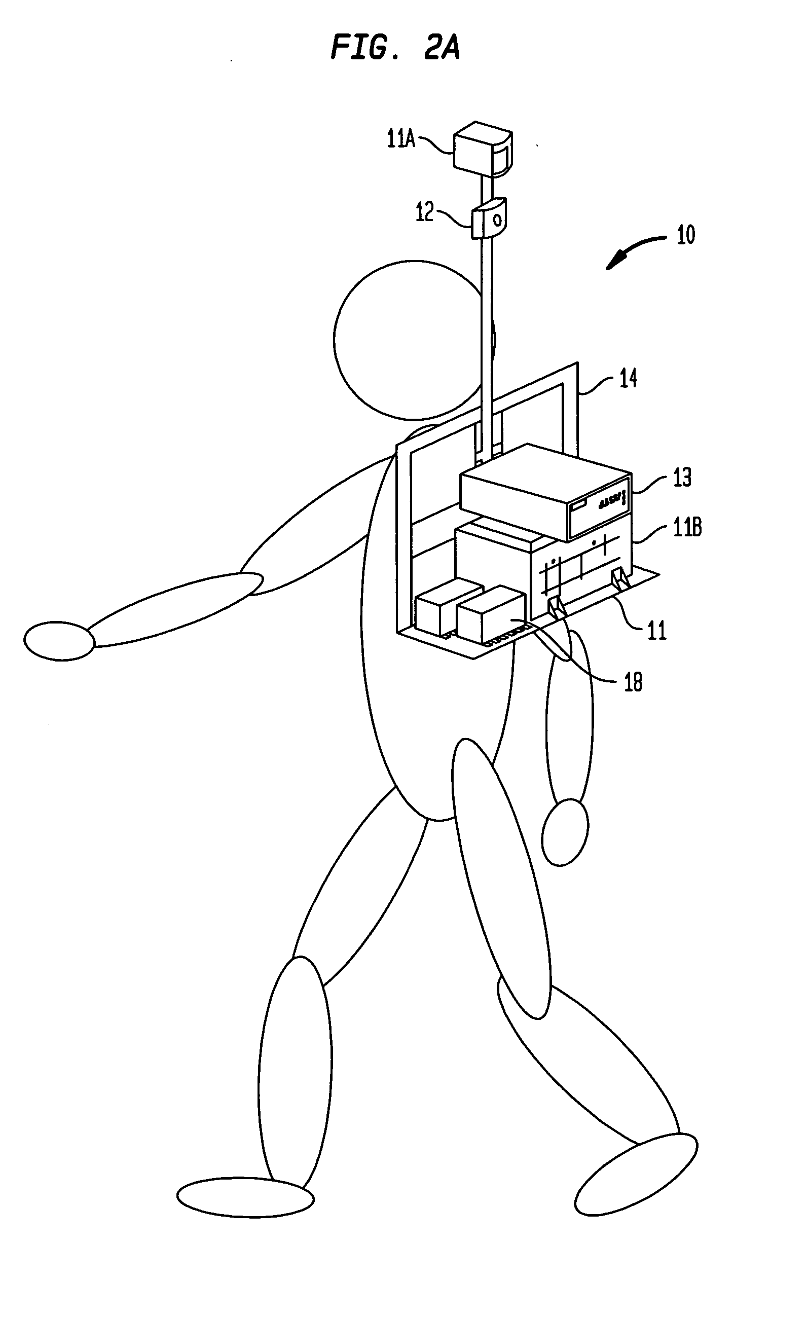
[0027]As used herein, the term “mobile mapping” means the collection of georeferenced data from a mobile platform, such as a person, or a land vehicle.

[0028]As used herein, the term “image data” means information which characterizes the visual attributes of a structure or object, other than location or position, such as color, reflectivity, brightness, texture, lighting and / or shading for example.

[0029]As used herein, the term “building structure” means walls, partitions, or other structure which define the interior space a building, such as a commercial building, residence building or the like.

[0030]As used herein, the term “position” means the geographical coordinates of longitude, latitude and altitude of an object or thing, such as a point.

[0031]...


PUM


Abstract

A system and method for acquiring spatial mapping information of surface data points defining a region unable to receive effective GPS signals, such as the interior of a building, includes an IMU for dynamically determining geographical positions relative to at least one fixed reference point, a LIDAR or camera for determining range of the IMU to each surface data point, and a processor to determine position data for each surface data point relative to the at least one reference point. A digital camera obtains characteristic image data, including color data, of the surface data points, and the processor correlates the position data and image data for the surface data points to create an image of the region.

Description

[0001]The present application is based upon and hereby claims the benefit of the filing date of prior-filed U.S. provisional application No. 61 / 124,722, filed Apr. 18, 2008.FIELD OF THE INVENTION[0002]The subject matter of the present application relates to obtaining georeferenced mapping data for a target structure or premises in absolute geographical coordinates, and in particular although not limited to, an aided-inertial based mapping system for mapping any region or structure where GPS signals are unavailable or insufficient for an accurate determination of position and location. An indoor mapping instrument is capable of generating indoor maps, for example, that are highly accurate and can be produced quickly by using the instrument while simply walking through the interior areas of the building.BACKGROUND OF THE INVENTION[0003]Maps enhance the value of positioning by effectively converting position information of natural and man-made objects, persons, vehicles and structures ...

Claims


Application Information

Patent Timeline
IPC IPC(8): G06K9/00G01C3/00
CPCG06T7/0042G01C3/08G06T7/73G01C21/206G01S17/42G01S17/89G01S7/4808G01S17/86G01C21/1652G01C21/1656
Inventor LITHOPOULOS, ERIK
Owner TRIMBLE NAVIGATION LTD
Why Eureka
Try Eureka