
Utilizing rapid water displacement detection systems and satellite imagery data to predict tsunamis

Inactive Publication Date: 2008-01-24
IBM CORP
View PDF14 Cites 22 Cited by
  • Summary
  • Abstract
  • Description
  • Claims
  • Application Information

AI Technical Summary

Benefits of technology

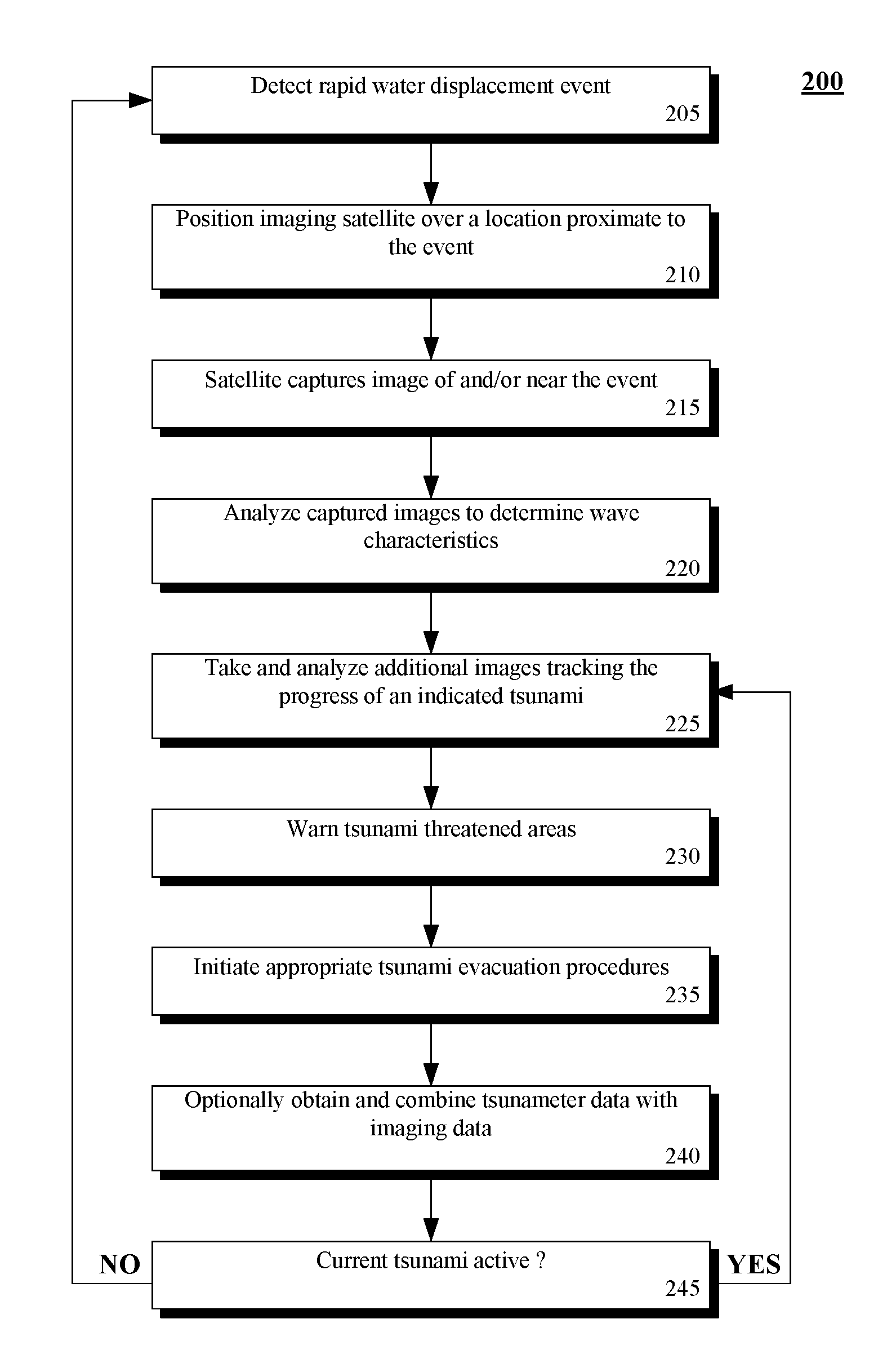
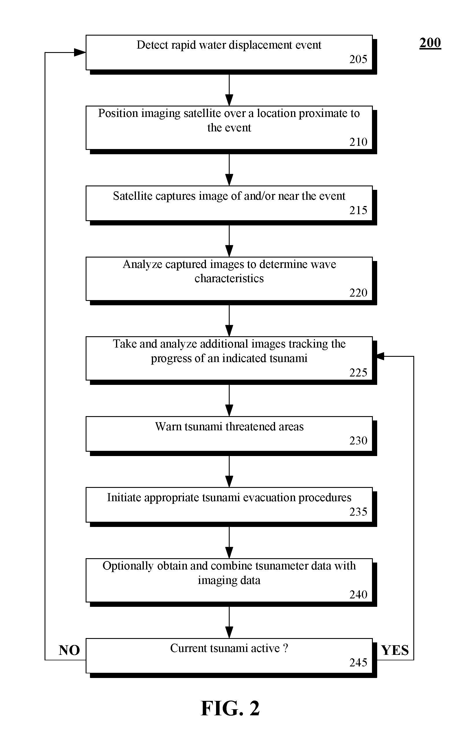
[0007]In more detail, the present invention can utilize existing detection systems and technologies to detect rapid water displacement events and the location of the same. Detection of these events can involve detecting seismic activity and / or detecting ionosphere disturbances. Once a rapid water displacement event is detected, a trigger event can be sent to satellite imaging systems to ensure that the area about the event is observed. Satellite obtained images can be analyzed to predict wave heights, speed, wave period, and direction of a potential tsunami. If a relatively high likelihood of a tsunami exists, one or more satellites can be automatically repositioned, if necessary, to ensure proper area coverage. An advantage of using satellites in this fashion is that these satellites are already deployed for numerous purposes including ocean monitoring and research. Additionally, satellite imagery tsunami detection techniques can be combined with traditional tsunameter-based detection to increase tsunami detection accuracy and to provide earlier tsunami warnings than is possible at present using conventional tsunameter-based systems.

Problems solved by technology

Technologies at that time were not, however, able to detect and track the tsunami that resulted from the underwater Earthquake.

Method used


Image

  • Utilizing rapid water displacement detection systems and satellite imagery data to predict tsunamis
  • Utilizing rapid water displacement detection systems and satellite imagery data to predict tsunamis
  • Utilizing rapid water displacement detection systems and satellite imagery data to predict tsunamis

Examples


Embodiment Construction

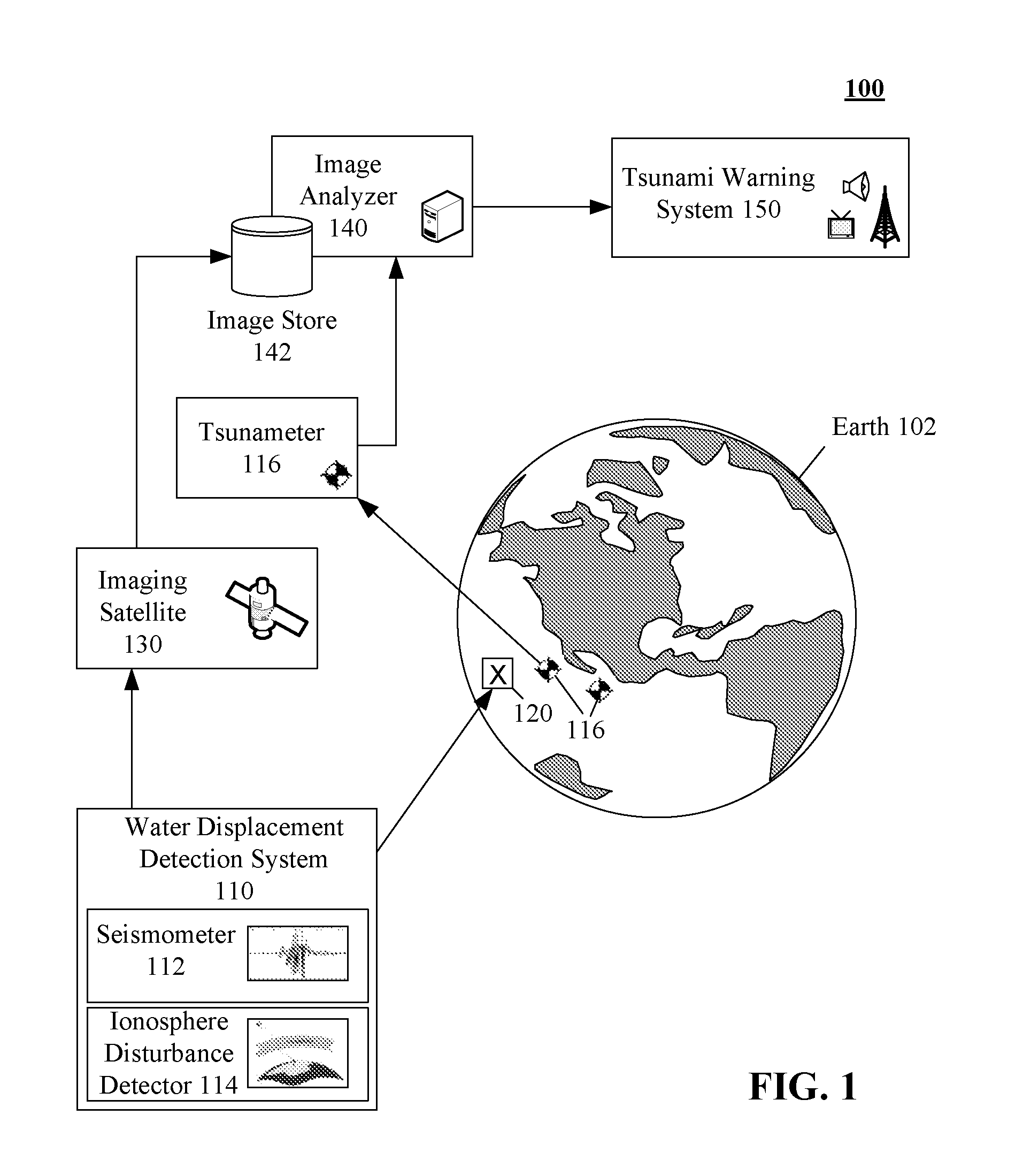
[0016]FIG. 1 is a schematic diagram of a tsunami detection and tracking system 100 in accordance with an embodiment of the inventive arrangements disclosed herein. The system 100 includes a water displacement detection system 110 that can detect and locate a water displacement event 120 occurring on the Earth 102.

[0017]A water displacement event 120 can be any event occurring in the ocean that results in a large volume of water being rapidly displaced. Water displacement events 120 have potential to result in a tsunami. Examples of water displacement events include, but are not limited to, underwater Earthquakes, landslides, volcanic eruptions, meteorite impacts, and the like.

[0018]The rapid water displacement detection system 110 can include seismometer 112 and ionosphere disturbance detector 114. A seismometer 112 also called a seismograph can be used to measure and record seismic waves. Seismometer 112 can be used to measure and locate Earthquakes and other ground motions, includ...


PUM


Abstract

One aspect of the present invention can include a method for detecting tsunamis that can include a step of detecting a location of a rapid water displacement event occurring in an ocean, such as an underground Earthquake. Images can be captured proximate to the event utilizing a satellite. The captured images can be analyzed to detect and / or track a tsunami.

Description

BACKGROUND[0001]1. Field of the Invention[0002]The present invention relates to the field of tsunami detection, and, more particularly, to utilizing rapid water displacement detection systems and satellite imagery data to predict and track tsunamis.[0003]2. Description of the Related Art[0004]A tsunami is an ocean wave or series of waves with a long period that results when a body of water, such as an ocean, is rapidly displaced on a massive scale. Tsunami forming events include underwater Earthquakes, landslides, volcanic eruptions, and meteorite impacts. A conventional solution for detecting tsunamis consists of a network of accurate, deep water pressure sensors called tsunameters that are connected to surface buoys, such as those used by the Deep Ocean Assessment and Reporting of Tsunamis (DART) project. The buoys transmit information via satellite to ground stations. The ground stations utilize this water pressure data to track tsunamis. When a tracked tsunami is predicted to im...

Claims


Application Information

Patent Timeline
IPC IPC(8): G06F19/00G06F17/40
CPCG01V1/008G01V1/01
Inventor BARKAL, JUDY L.KATZ, NEIL A.
Owner IBM CORP
Learn More