
Navigation System and Method for Controlling the Same

a technology which is applied in the field of navigation system and control method, can solve the problems of high price of communication module for cdma or gsm, posing an obstacle to the development of low and medium-priced navigation system, and almost impossible to get guided on the travel of a mobile object in real time, and achieves the effect of moderate pri

Inactive Publication Date: 2007-10-18
LG ELECTRONICS INC
View PDF10 Cites 35 Cited by
  • Summary
  • Abstract
  • Description
  • Claims
  • Application Information

AI Technical Summary

Benefits of technology

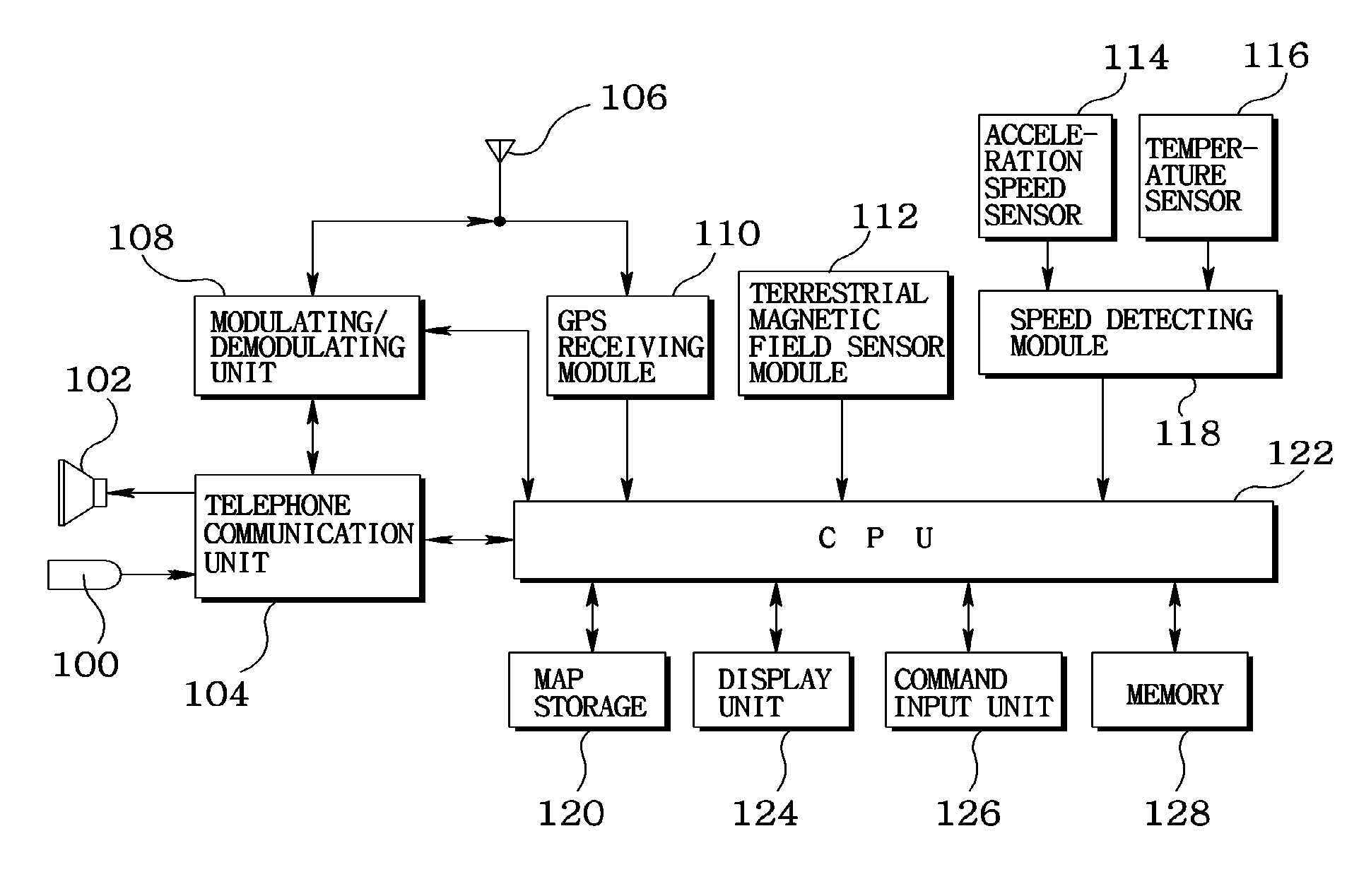
The present invention provides a navigation system and method for guiding a mobile object using a mobile communication terminal equipped with a GPS receiving module, a terrestrial magnetism sensor module, an acceleration speed sensor, a speed detecting module, and a map storage. The system can accurately determine the current position of the mobile object and display it on a map in real-time, making it easier for users to navigate to their destination. The invention also integrates the functions necessary for implementing navigation services in a mobile communication terminal, making it a low-cost solution for guiding mobile objects.

Problems solved by technology

However, a communication module for CDMA or GSM is very expensive to pose as an obstacle to the development of low and medium priced navigation systems.
In other words, there is a problem in the navigation services using the conventional mobile communication terminals in that a user accesses to a navigation service provider via his or her mobile communication terminal to download map and traffic information, and the downloaded map and traffic information are displayed on a screen such that it takes some time to get downloaded with the map and traffic information, making it almost impossible to get guided on the travel of a mobile object in real time.
There is another problem in that, although information such as travel speed and travel direction of a mobile object is needed for precisely guiding a current position and a travel state of the mobile object, the mobile communication terminal cannot accurately obtain information such as a travel speed and a travel direction of a mobile object on a real time base.
There is still another problem in that, although navigation messages received by a GPS receiving module mounted in a mobile communication terminal can be used to extract information such as a travel speed and a travel direction, a current position and a travel of a mobile object cannot be accurately guided because a period in which the GPS receiving module receives the navigation messages is approximately over 1 second.

Method used


Image

  • Navigation System and Method for Controlling the Same
  • Navigation System and Method for Controlling the Same
  • Navigation System and Method for Controlling the Same

Examples


Embodiment Construction

[0031]FIG. 1 is a block diagram illustrating a construction of a navigation system according to the present invention, where reference numeral 100 denotes a microphone, 102 denotes a speaker, and 104 denotes a telephone communication unit. The telephone communication unit receives a voice signal of a user via the microphone (100) and processes the voice signal. The telephone communication unit (100) also outputs a voice signal of a caller inputted from the modulating / demodulating unit (108. described later) to the speaker (102) to allow a user to effect a telephone communication.

[0032] Reference numeral 106 denotes an antenna, and 108 denotes a modulating / demodulating unit. The modulating / demodulating unit 108 demodulates the voice signal of a caller received via the antenna (106) and outputs the demodulated voice signal to the telephone communication unit (104), and modulates a voice signal of a user inputted from the telephone communication unit (104) and transmits the modulated ...


PUM


Abstract

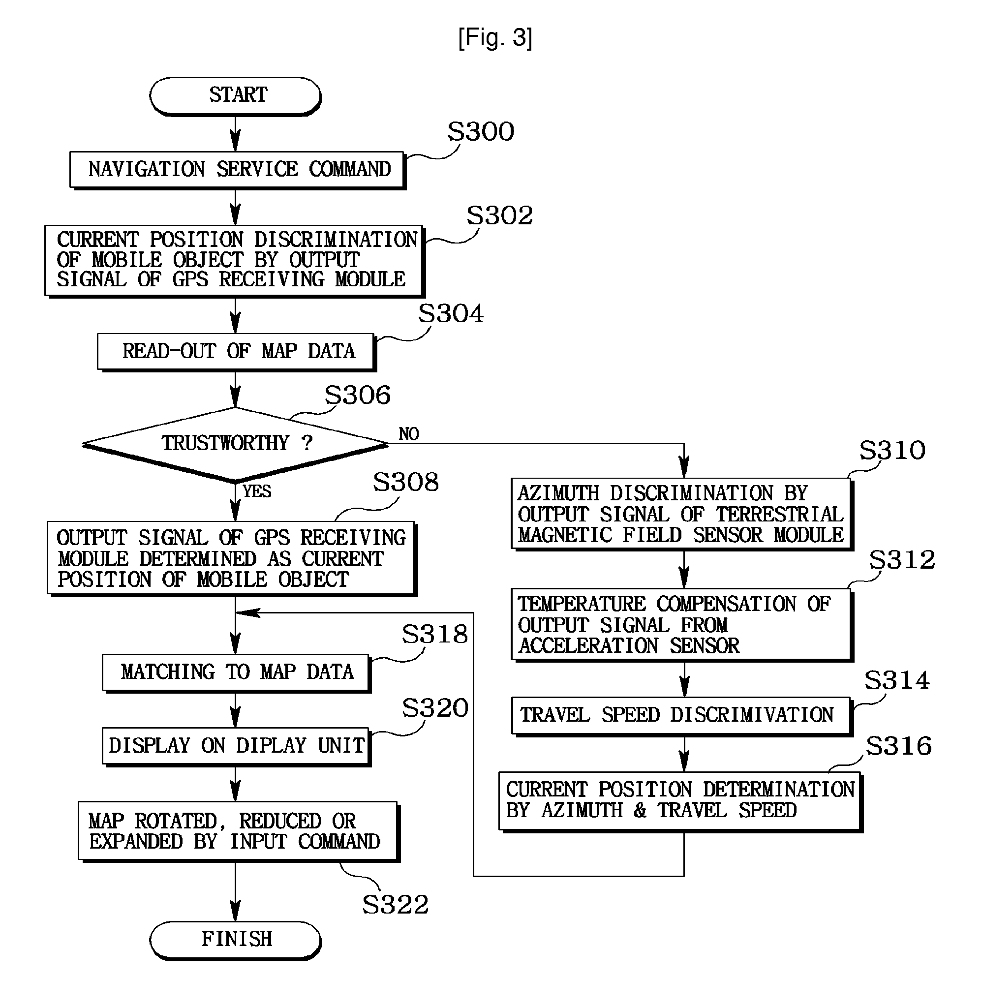
A navigation system and a method for controlling the same wherein navigation functions are integrally mounted in a mobile communication terminal to enable to guide the travel of a mobile object in real time. A GPS receiving module is integrally mounted in the mobile communication terminal to receive navigation messages transmitted by the GPS satellites and to detect the position of the mobile object, terrestrial magnetic field is detected by a terrestrial magnetic field sensor module to detect an azimuth of the mobile object, an acceleration speed is detected by an acceleration speed sensor, and the travel speed of the mobile object is calculated by a speed detecting module using the acceleration speed thus detected, a current position of the mobile object is determined by an output signal from the GPS receiving module, the terrestrial magnetic field sensor module, and the speed detecting module, and the current position of the mobile object thus determined is matched to a map data stored in a map storage for display in a display unit.

Description

TECHNICAL FIELD [0001] The present invention relates to a navigation system and a method for controlling the same adapted to be equipped at a mobile communication terminal to guide a travel of a predetermined mobile object. BACKGROUND ART [0002] Concomitant with the development of position acquisition technology using Global Positioning System (GPS) and the field of telematics which is multimedia system used in a mobile object such as a vehicle, necessity of low and medium priced navigation systems has been continuously proposed. [0003] Generally, the navigation system includes a position acquisition module for acquiring a current position information of a predetermined mobile object, a route calculation module for calculating a travel route of the mobile object, and a route guide module for guiding a travel route of the mobile object. The navigation system further includes a communication module for receiving supplementary services such as traffic information and the like. [0004] T...

Claims


Application Information

Patent Timeline
Patent Type & Authority Applications(United States)
IPC IPC(8): G01C21/10G01C21/34G01C21/20G01C21/28G08G1/0969G01C21/30
CPCG01C21/30G01C21/20G08G1/0969
Inventor JUNG, MUN HOYI, DONG HOON
Owner LG ELECTRONICS INC
Learn More