Method and system for using cellular date for transportation planning and engineering

a technology of applied in the field of system and method for using wireless telephony network data for transportation planning and engineering, can solve the problems of high cost of data collection using traditional methods and traditionally difficult to capture data

Active Publication Date: 2006-12-28
AIRSAGE INC
View PDF13 Cites 86 Cited by
  • Summary
  • Abstract
  • Description
  • Claims
  • Application Information

AI Technical Summary

Benefits of technology

[0009] In another aspect of the present invention, a method for using data from a wireless telephony network for associating a mobile station with a geographic region is disclosed. The method includes (1) retrieving a location record associated with the mobile station; (2) establishing one or more criteria for associating the mobile station with the primary transportation analysis zone; and (3) applying the one or more criteria to associate the mobile station with the primary transportation analysis zone. The criteria relate the mobile station to the primary transportation analysis zone based on a time parameter associated with the mobile station and the primary transportation analysis zone.
[0010] In yet another aspect of the present invention, a method for using data from a wireless telephony network for identifying an origin and a destination for a trip made by a user of a mobile station is disclosed. The method includes (1) identifying a first location record for the mobile station comprising a first geographic region associated with the origin of a trip; (2) identifying one or more subsequent location records for the mobile station associated with the trip; and (3) identifying a second geographic region for the destination for the trip. The one or more of the subsequent location records for the mobile station include the second geographic region for a set time interval.
[0011] The aspects of the present invention may be more clearly understood and appreciated from a review of the following detailed description of the disclosed embodiments and by reference to the drawings and claims.

Problems solved by technology

The high cost of data collection using the traditional methods identified above often requires planners and engineers to make liberal assumptions, extrapolations, and inferences that may lead to erroneous conclusions.
These data have traditionally been difficult to capture.

Method used


Image

  • Method and system for using cellular date for transportation planning and engineering
  • Method and system for using cellular date for transportation planning and engineering
  • Method and system for using cellular date for transportation planning and engineering

Examples


Embodiment Construction

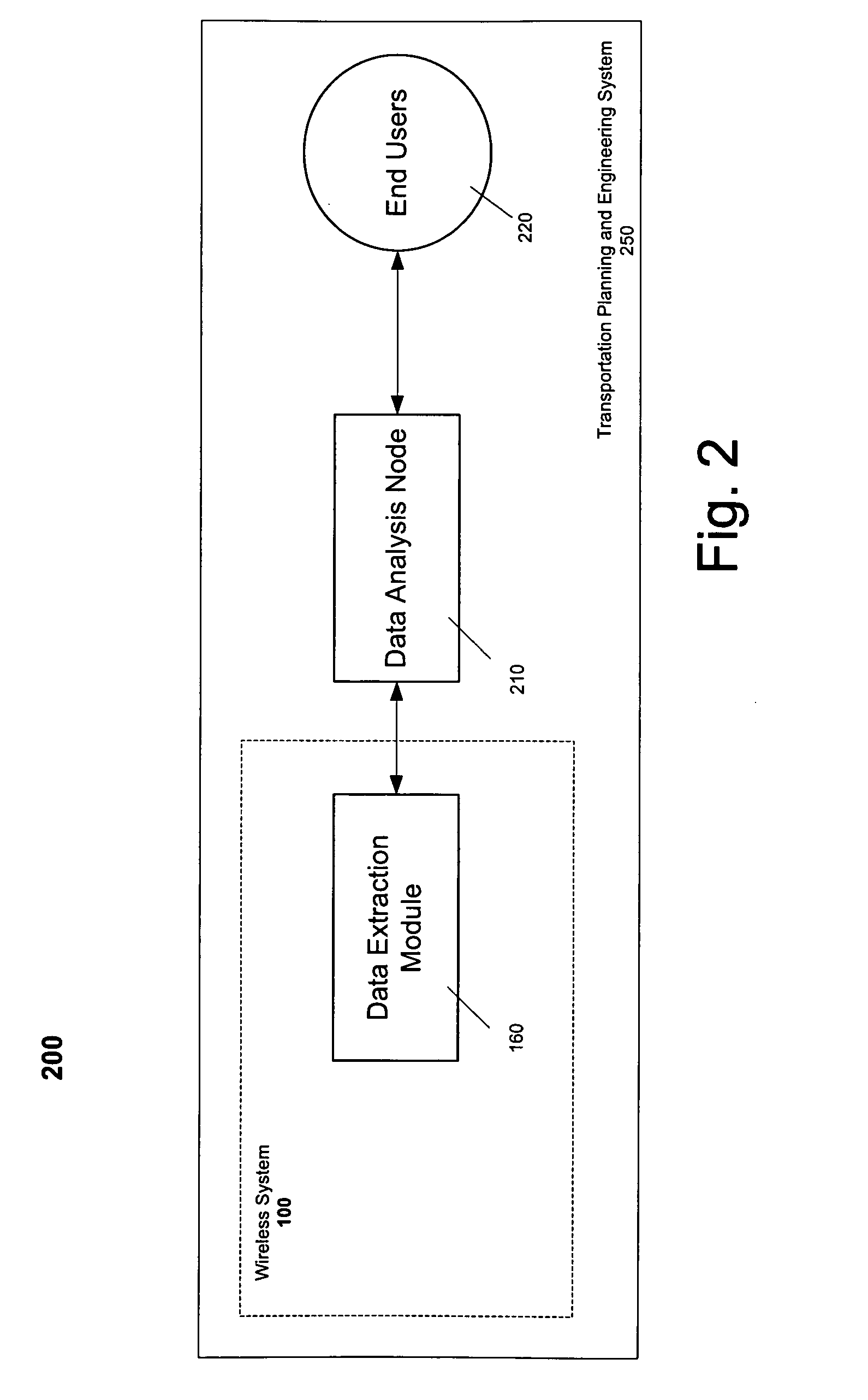
[0033] Exemplary embodiments of the present invention provide systems and methods for using data from a wireless telephony network to support transportation planning and engineering. Data related to wireless network users is extracted from the wireless network to determine the location of a mobile station. Additional location records for the mobile station can be used to characterize the movement of the mobile station: its speed, its route, its point of origin and destination, and its primary and secondary transportation analysis zones. Aggregating data from multiple mobile stations allows characterizing and predicting traffic parameters, including traffic speeds and volumes along routes.

[0034]FIG. 1 depicts an operating environment in relation to a wireless telephony network 100 in accordance with an exemplary embodiment of the present invention. Referring to FIG. 1, mobile station (MS) 105 transmits signals to and receives signals from a radiofrequency transmission tower 110 whil...


PUM


Abstract

Using data from a wireless telephony network to support transportation planning and engineering. Data related to wireless network users is extracted from the wireless network to determine the location of a mobile station. Additional location records for the mobile station can be used to characterize the movement of the mobile station: its speed, its route, its point of origin and destination, and its primary and secondary transportation analysis zones. Aggregating data associated with multiple mobile stations allows characterizing and predicting traffic parameters, including traffic speeds and volumes along routes.

Description

STATEMENT OF RELATED PATENT APPLICATIONS [0001] This non-provisional patent application claims priority under 35 U.S.C. § 119 to U.S. Provisional Patent Application No. 60 / 693,283, titled Method and System for Using Cellular Data for Transportation Planning and Engineering, filed Jun. 23, 2005. This provisional application is hereby fully incorporated herein by reference.FIELD OF THE INVENTION [0002] This invention relates to a system and method for using wireless telephony network data for transportation planning and engineering. More particularly, this invention relates to determining traffic patterns and road usage based on determining locations over time of wireless telephony users to support transportation planning and engineering. BACKGROUND OF THE INVENTION [0003] Transportation planning and engineering relies heavily on empirical data and extensive use of data analysis techniques that characterize and predict the flow of traffic in a geographic region. The use of these traff...

Claims


Application Information

Patent Timeline
Patent Type & Authority Applications(United States)
IPC IPC(8): H04Q7/20H04W16/00
CPCG06Q10/06G06Q10/10G08G1/00H04W16/00G08G1/012
Inventor SMITH, CYRUS W.
Owner AIRSAGE INC
Why Eureka
Try Eureka