
Position estimation in a low earth orbit satellite communications system

a satellite communications system and satellite technology, applied in the field of satellite communications system position estimation, can solve the problems of adding significant cost and power requirements to the terminal, placing significant burden on the power requirements of the terminal, etc., and achieve the effect of improving the satellite position estimation

Active Publication Date: 2021-03-23
MYRIOTA PTY LTD
View PDF7 Cites 1 Cited by
  • Summary
  • Abstract
  • Description
  • Claims
  • Application Information

AI Technical Summary

Benefits of technology

[0019]receiving, at the satellite, one or more beacon signals from a terrestrial or space based source, the beacon signal comprising the beacons position and global timing with respect to a reference, and the satellite forwards samples of the signal to the ground station, and estimating the location of the terminal further comprises estimating at least one of a beacon delay, a beacon Doppler or a beacon Doppler rate for each beacon signal. This estimate can be used to improve the estimate of the satellite position and thus the terminal position.

Problems solved by technology

In cold start it takes a GPS receiver 12 minutes to download the full almanac placing significant burden on power requirements for the terminal.
In applications with remote terminals 10 as discussed above, this requirement can add significant cost and power requirements to terminals 10.

Method used


Image

  • Position estimation in a low earth orbit satellite communications system
  • Position estimation in a low earth orbit satellite communications system
  • Position estimation in a low earth orbit satellite communications system

Examples


Embodiment Construction

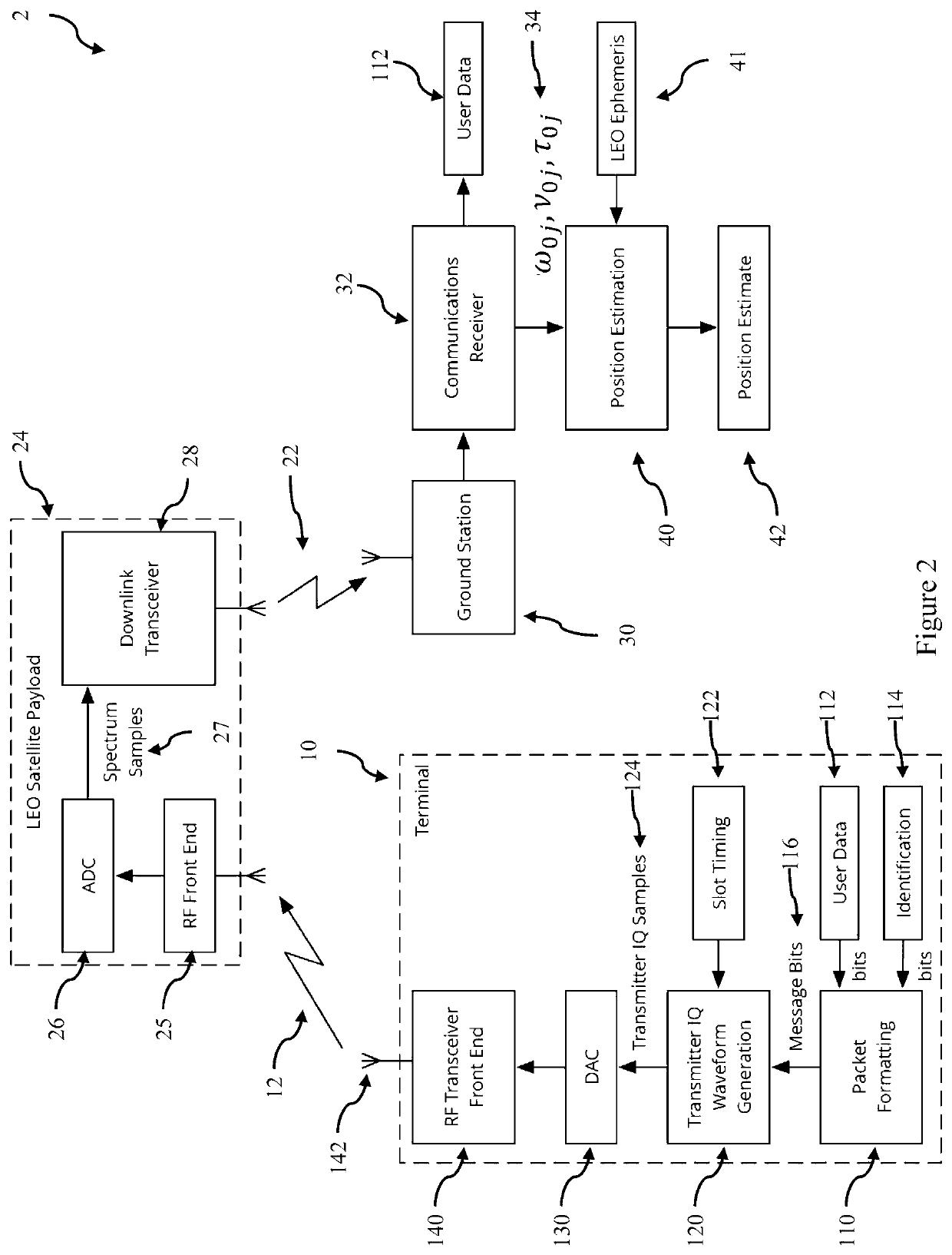
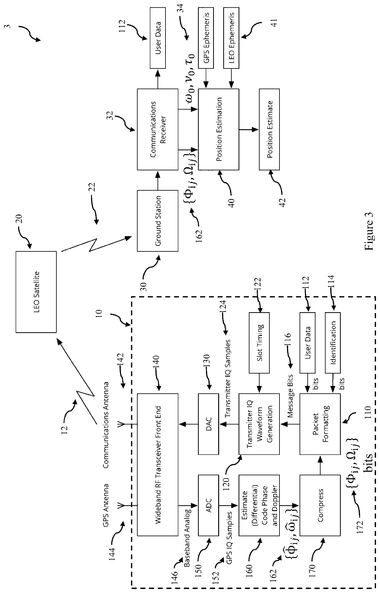
[0043]FIG. 1 is a schematic diagram of a low earth orbit satellite communications system according to an embodiment illustrating the broad system components and signal paths. The satellite communications system 1 is comprised of ground-based transceivers, referred to as terminals 10, transmitting data 12 using radio signals to one or more low-earth-orbiting satellites 20. These satellites transmit signals 22 to relay the terminals' radio signals to ground stations 30 where the received signals 22 are decoded and delivered to the destination. FIG. 2 is a more detailed schematic representation of this system showing various modules for performing position estimation from Doppler and delay estimates as described herein.

[0044]Embodiments of the system and method obtain a location estimate from measurements derived from the time-of flight (transmission path length from the terminal to the satellite), relative Doppler frequency (first derivative of path length), and rate of change of Dopp...


PUM


Abstract

A method for estimating the position of a terminal in a satellite communication at either the ground station or in the satellite is described. The method uses estimates of the time delay, Doppler and / or Doppler Rate of signals transmitted from the terminal to the satellite together with an estimate of the satellite position. The method can be used with both synchronised terminals and unsynchronised terminals provided they have a stable time or frequency reference as well as with low earth orbit satellites both with and without on-board global position and timing references. Additionally the method can also use estimates of the time delay, Doppler or Doppler rate of beacon signals received by either the satellite or terminals. These beacon signals may include GPS L1 signals. In contrast to standard GPS receivers, the method does not require the terminal to store GPS ephemeris data or to operate continuously.

Description

CROSS-REFERENCE TO RELATED APPLICATION(S)[0001]The present application claims priority from Australian Provisional Patent Application No. 2016901913 titled “Position Estimation in a Low Earth Orbit Satellite Communications System” and filed on 20 May 2016, the content of which is hereby incorporated by reference in its entirety.BACKGROUNDTechnical Field[0002]The present disclosure relates to estimation of the position of a ground-based transceiver in a satellite communications system. In a particular form the present disclosure relates systems in which estimation is performed remote from the terminal.Description of the Related Art[0003]This application is directed to satellite communications system 1 that is comprised of ground-based transceivers, referred to as terminals 10, transmitting data 12 using radio signals to one or more low-earth-orbiting satellites 20. These satellites transmit signals 22 to relay the terminals' radio signals to ground stations 30 where the received sign...

Claims


Application Information

Patent Timeline
Patent Type & Authority Patents(United States)
IPC IPC(8): G01S19/48H04W4/029H04B7/195G01S19/46H04W4/024G01S5/00G01S5/02H04B7/185G01S5/12H04W4/02
CPCG01S19/48G01S5/0009G01S5/0252G01S19/46H04B7/195H04W4/024H04W4/029G01S5/0257G01S5/12H04B7/18523G01S5/0036G01S19/09H04W4/02
Inventor HALEY, DAVID VICTOR LAWRIEGRANT, ALEXANDER JAMESMCKILLIAM, ROBERT GEORGEPOLLOK, ANDRE
Owner MYRIOTA PTY LTD
Learn More