Land application variety detection based on historical maps or drawings

A technology of historical land and change detection, applied in the direction of using re-radiation, geophysical measurement, measuring devices, etc., to achieve the effect of historical data reuse

Inactive Publication Date: 2006-01-18
牛铮 +2
View PDF0 Cites 13 Cited by
  • Summary
  • Abstract
  • Description
  • Claims
  • Application Information

AI Technical Summary

Problems solved by technology

Although people try to use the same seasonal image pair when using different methods for change detection, the above-mentioned interference cannot be eradicated

Method used


Image

  • Land application variety detection based on historical maps or drawings
  • Land application variety detection based on historical maps or drawings
  • Land application variety detection based on historical maps or drawings

Examples


Embodiment Construction

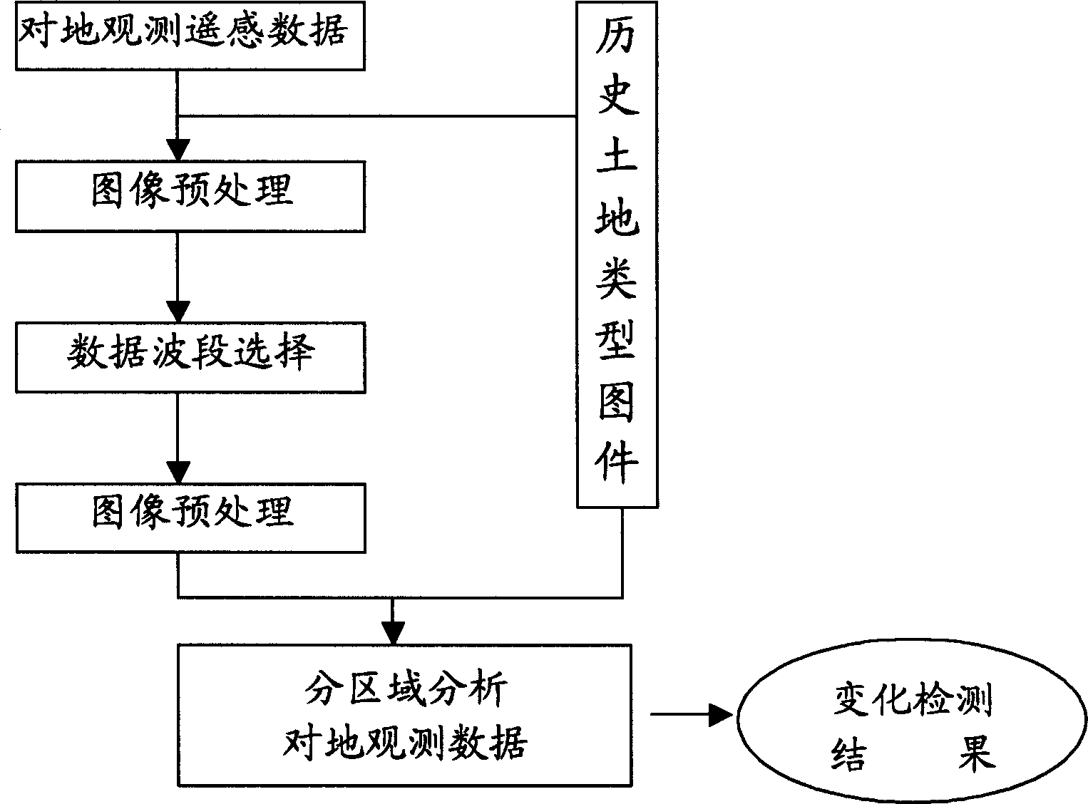
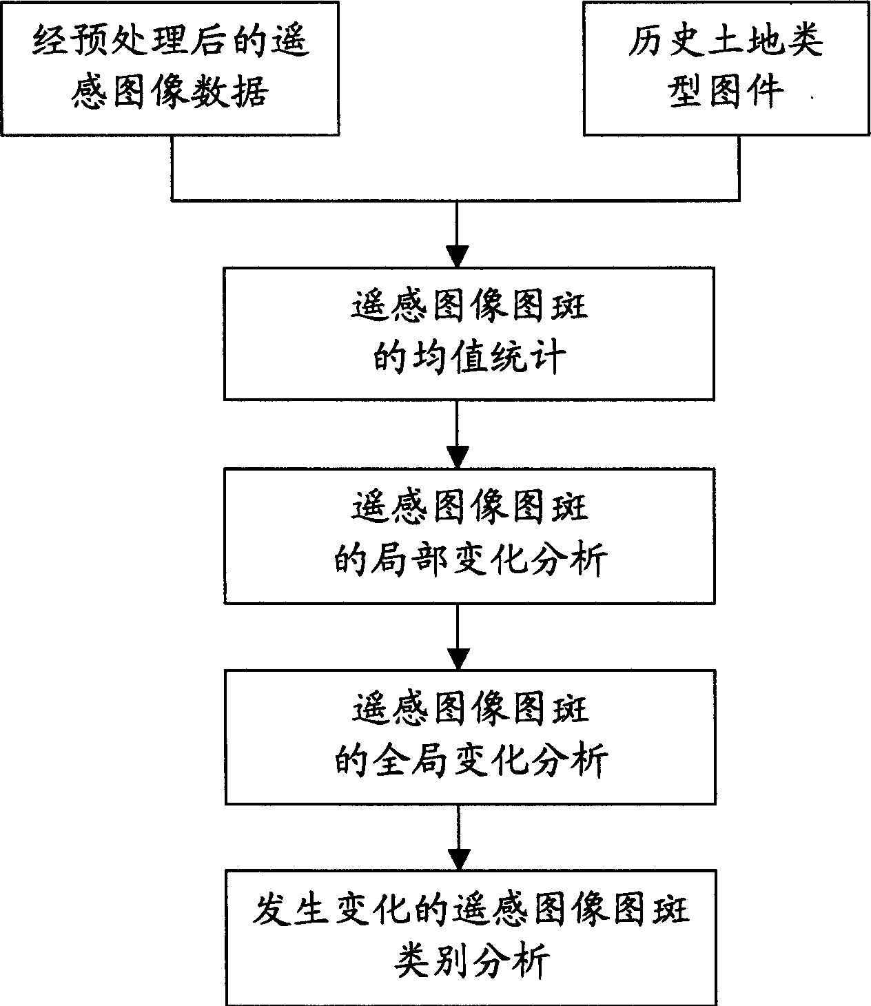
[0013] like figure 1 As shown, the present invention provides a method of combining historical land use maps and existing images to detect changes in ground features. The specific implementation includes: obtaining necessary earth observation remote sensing data and corresponding historical land type maps; Perform data matching processing on the obtained earth observation remote sensing data; perform data band selection on the obtained earth observation remote sensing data; analyze the earth observation data by region according to the distribution of each land type in the historical land type maps, and compare the land observation data of each type Statistical characteristics of observed data in the region to obtain land use change results.

[0014] During the implementation of the present invention, historical map data and remote sensing data need to be used.

[0015] Historical map data: Refers to land use type data obtained through various channels in historical years. The...


PUM


Abstract

The invention discloses a remote sensing change measuring method in land application / covering. The invention uses new type remote sensing change measuring method and forms land type research results compounded with history; then it uses these results to form map (generally these are vector or grille type with vector spot characters) and dose in turn detecting to the change of land application / covering.

Description

technical field [0001] The present invention relates to the application technology of information resources, in particular to the application technology of using information obtained by remote sensing technology to provide auxiliary information for change detection applications such as changes in land resources, forestry resource investigations, and changes in agricultural land. Background technique [0002] Change detection is to observe the state of the target or phenomenon in different periods, and quantitatively analyze and determine the characteristics and process of the change of the target or phenomenon. It involves the type, distribution and amount of change, that is, it is necessary to determine the ground type, boundary and change trend before and after the change. [0003] In the past 20 years, many scholars have carried out research work on the dynamic monitoring method of land use / cover change based on satellite remote sensing. At present, the methods that are ...

Claims


Application Information

Patent Timeline
Patent Type & Authority Applications(China)
IPC IPC(8): G01V3/00
Inventor 牛铮李向军王汶
Owner 牛铮
Why Eureka
Try Eureka