Geographic surveying and mapping data acquisition and processing system based on big data
A technology for data acquisition and processing and data acquisition module, which is applied in the field of geographic surveying and mapping, can solve the problems of monitoring the working state of data acquisition equipment without the availability, and achieve the effect of speeding up maintenance efficiency.
- Summary
- Abstract
- Description
- Claims
- Application Information
AI Technical Summary
Problems solved by technology
Method used
Image
Examples
Embodiment 1
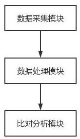
[0037] like figure 1As shown, a big data-based geographic surveying and mapping data collection and processing system includes a data collection module, a data processing module and a comparison and analysis module, which are connected in sequence.
[0038] Before the surveying and mapping data is collected, place the drone in the target area and start the data acquisition module to collect the target area image according to the shooting position and shooting parameters of the target area image stored in the image database. The shooting parameters include the inclination angles of the four oblique slices; the shooting position and shooting parameters of the target area image are set by the administrator; the data acquisition module includes a camera, the camera is set on the drone, and the camera includes One positive and four oblique films, through the combination of positive and oblique films, in the process of geographic information mapping, oblique images have significant ...
Embodiment 2
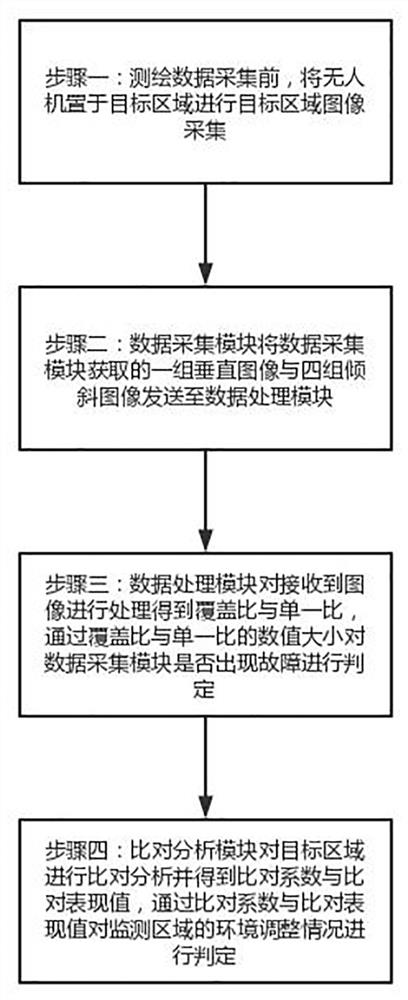
[0042] like figure 2 As shown, a method for collecting and processing geographic surveying and mapping data based on big data includes the following steps:
[0043] Step 1: Before collecting the surveying and mapping data, place the drone in the target area to collect images of the target area;
[0044] Step 2: the data acquisition module sends a set of vertical images and four sets of oblique images acquired by the data acquisition module to the data processing module;
[0045] Step 3: The data processing module processes the received images to obtain the coverage ratio and the single ratio, determines whether the data acquisition module is faulty according to the numerical value of the coverage ratio and the single ratio, and conducts maintenance and treatment according to the type of the acquisition fault;
[0046] Step 4: The comparison analysis module compares and analyzes the target area and obtains the comparison coefficient and the comparison performance value, and j...
PUM
 Abstract
Description
Claims
Application Information
 - R&D Engineer
- R&D Manager
- IP Professional
- Industry Leading Data Capabilities
- Powerful AI technology
- Patent DNA Extraction
Browse by: Latest US Patents, China's latest patents, Technical Efficacy Thesaurus, Application Domain, Technology Topic, Popular Technical Reports.
© 2024 PatSnap. All rights reserved.Legal|Privacy policy|Modern Slavery Act Transparency Statement|Sitemap|About US| Contact US: help@patsnap.com


