Method for inverting high-resolution submarine topography nonlinearity through local sea area disturbance gravity data

A technology for perturbing gravity and data inversion. It is applied in the measurement of gravitational fields, complex mathematical operations, geophysical measurements, etc. It can solve the problems of low accuracy of theoretical inversion and achieve the effect of being easy to popularize and use.

Pending Publication Date: 2022-07-29
中国人民解放军61540部队
View PDF0 Cites 0 Cited by
  • Summary
  • Abstract
  • Description
  • Claims
  • Application Information

AI Technical Summary

Problems solved by technology

In the inversion method of seabed terrain grid model, the gravity geological method, analytical method, frequency domain method, least squares allocation method, etc. are widely used at present. The above methods generally linearize the analytical model and take the first-order item for calculation. Theoretical inversion accuracy is low due to the neglect of higher-order terms between gravity and sea depth
At the same time, although the numerical size of the above-mentioned grid model reaches 1′ (about 1.8km), its real resolution is about 10-30km because the filtering process of 10-30km is often used in the process of constructing the grid. The high-resolution variable rate inversion method still needs to be optimized and improved

Method used


Image

  • Method for inverting high-resolution submarine topography nonlinearity through local sea area disturbance gravity data
  • Method for inverting high-resolution submarine topography nonlinearity through local sea area disturbance gravity data
  • Method for inverting high-resolution submarine topography nonlinearity through local sea area disturbance gravity data

Examples


Embodiment Construction

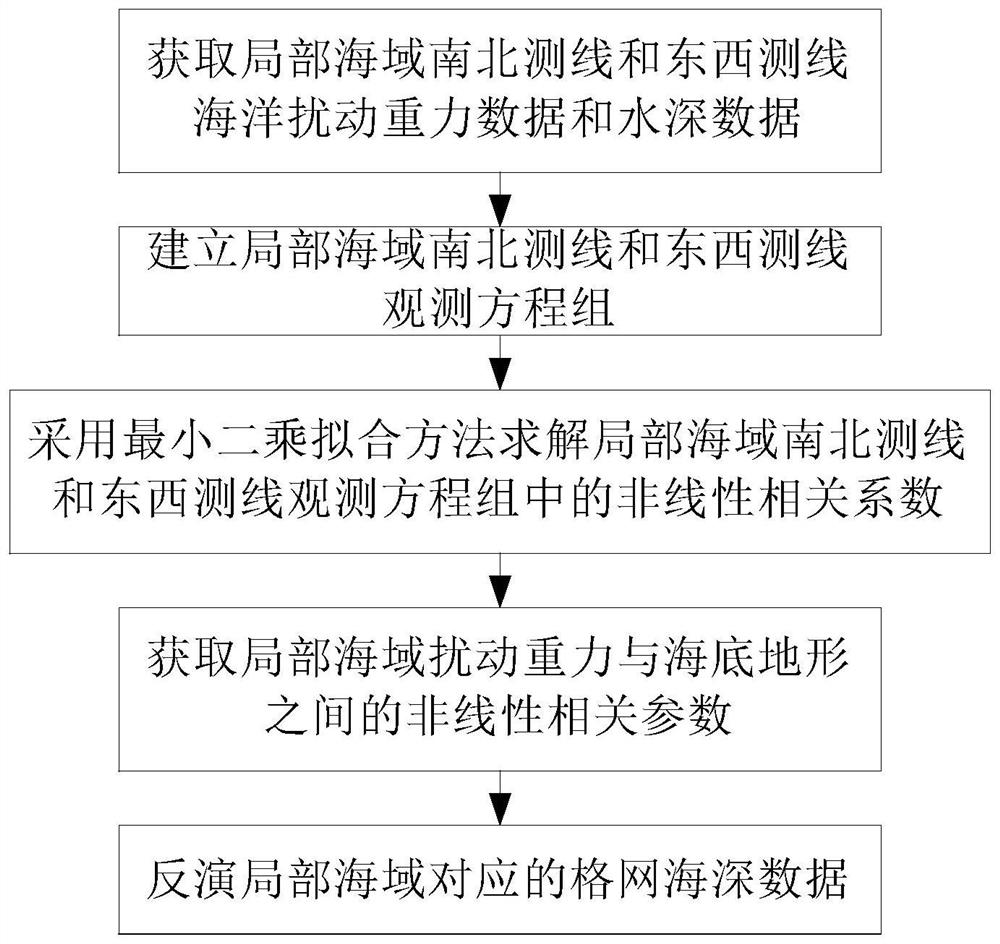
[0018] like figure 1 As shown, the nonlinear method for inverting high-resolution seabed topography from local sea area disturbance gravity data of the present invention includes the following steps:

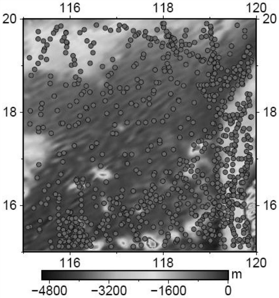
[0019] Step 1. Obtain the ocean disturbance gravity data and bathymetric data of the north-south survey line and the east-west survey line in the local sea area: use the shipborne gravity bathymetry method to obtain the ocean disturbance gravity data and bathymetry data of the north-south survey line and the east-west survey line passing through the center of the local sea area respectively Sampling data set, ie {(h sn1 ,δg sn1 ),(h sn2 ,δg sn2 ),...,(h sni ,δg sni ),...,(h snI ,δg snI )} and {(h ew1 ,δg ew1 ),(h ew2 ,δg ew2 ),...,(h ewj ,δg ewj ),...,(h ewJ ,δg ewJ )}, where {(h sn1 ,δg sn1 ),(h sn2 ,δg sn2 ),...,(h sni ,δg sni ),...,(h snI ,δg snI )} is the sampling data collection of ocean disturbance gravity data and bathymetric data of the north-south...


PUM


Abstract

The invention discloses a nonlinear method for inverting high-resolution submarine topography from local sea area disturbing gravity data. The method comprises the following steps: 1, acquiring ocean disturbing gravity data and water depth data of a south-north measuring line and an east-west measuring line of a local sea area; 2, establishing a local sea area south-north survey line and east-west survey line observation equation set; 3, solving a nonlinear correlation coefficient in the observation equation set of the south-north survey line and the east-west survey line of the local sea area by adopting a least square fitting method; 4, nonlinear correlation parameters between the local sea area disturbance gravity and the submarine topography are obtained; and 5, inverting grid sea depth data corresponding to the local sea area. According to the method, two mutually perpendicular gravity and water depth sequence measuring lines are obtained by carrying out south-north and east-west ship load water depth measurement in a local area, and the two measuring lines are used for fitting to obtain south-north and east-west nonlinear correlation function parameters; and then the parameters are combined with satellite altimetry gravity data to invert the submarine topography of the corresponding area.

Description

technical field [0001] The invention belongs to the technical field, and in particular relates to a nonlinear method for inverting high-resolution seabed topography from local sea area disturbance gravity data. Background technique [0002] At present, shipborne multibeam measurement and satellite radar altimetry inversion are mainly used to determine the seabed topography in the wide seas of the world. Shipborne multibeam, airborne laser bathymetry, and multispectral inversion are generally used for sea depths in narrow waterways, offshore and tidal flat areas. Acting and other technologies are confirmed. When shipborne multi-beam measurement and gravity measurement are carried out at the same time, high-precision disturbed gravity / water depth data of a certain survey line in the ocean area can be obtained. However, limited by the measurement platform and the objective marine environmental conditions, the shipborne measurement technology can only be obtained in local areas....

Claims


Application Information

Patent Timeline
IPC IPC(8): G01V7/00G06F17/12G06F17/15
CPCG01V7/00G06F17/12G06F17/15
Inventor 翟振和马健管斌李端欧阳明达
Owner 中国人民解放军61540部队
Why Eureka
Try Eureka