Automatic obstacle avoidance surveying and mapping unmanned aerial vehicle for water conservancy

An automatic obstacle avoidance and drone technology, applied in the field of surveying and mapping drones, can solve problems such as damage, collision, and large detection blind spots of surveying and mapping drones, and achieve the effect of improving the radial detection range and expanding the detection range

Active Publication Date: 2022-05-24
广州一诺智能信息工程有限公司
View PDF12 Cites 0 Cited by
  • Summary
  • Abstract
  • Description
  • Claims
  • Application Information

AI Technical Summary

Problems solved by technology

[0003] The existing water-use automatic obstacle avoidance surveying and mapping drone detects the flying direction of the surveying and mapping drone by installing a detector on the drone. When an obstacle is detected, the controller needs to manually check the direction of the surveying and mapping drone. The flight path is adjusted, and since the detector can only detect the direction of travel, there is a large detection blind spot, which may easily cause the surveying and mapping UAV to collide with moving obstacles in other directions during the flight, resulting in unmanned surveying and mapping. machine damage

Method used


Image

  • Automatic obstacle avoidance surveying and mapping unmanned aerial vehicle for water conservancy
  • Automatic obstacle avoidance surveying and mapping unmanned aerial vehicle for water conservancy
  • Automatic obstacle avoidance surveying and mapping unmanned aerial vehicle for water conservancy

Examples


Embodiment

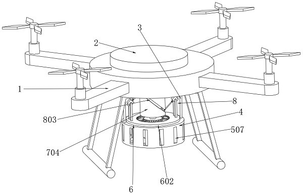
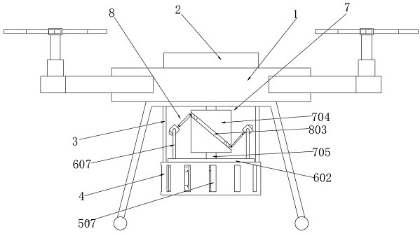
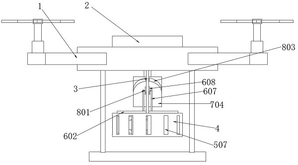
[0037] Example: as Figure 1-Figure 9 As shown, the present invention provides the following technical solutions: a water-utilized automatic obstacle avoidance surveying and mapping drone, the water-utilizing automatic obstacle avoidance surveying and mapping drone includes a drone body 1, and the drone body 1 is fixedly installed with Controller 2, two mounting rods 3 are fixedly installed at the bottom of the drone body 1, and a box body 4 is fixedly installed at the end of the mounting rod 3 away from the drone body 1, and the box body 4 is a cylinder The box body 4 is provided with a drive assembly 5, the drive assembly 5 is connected with the radial adjustment assembly 6, and a detector 608 is installed on the radial adjustment assembly 6, and the detector 608 is connected to the controller. 2. Electrically connected, a transmission assembly 7 is installed at the bottom of the drone body 1, and the transmission assembly 7 is connected with the detector 608 through the lon...


PUM


Abstract

The invention discloses an automatic obstacle avoidance surveying and mapping unmanned aerial vehicle for water conservancy, which comprises an unmanned aerial vehicle body, a controller is fixedly mounted on the unmanned aerial vehicle body, two mounting rods are fixedly mounted at the bottom of the unmanned aerial vehicle body, a box body is fixedly mounted at the end part, far away from the unmanned aerial vehicle body, of each mounting rod, and the box body is a cylindrical box; the surveying and mapping unmanned aerial vehicle comprises an unmanned aerial vehicle body, the unmanned aerial vehicle body is provided with a box body, the box body is provided with a driving assembly, the driving assembly is connected with a radial adjusting assembly, the radial adjusting assembly is provided with a detector, the bottom of the unmanned aerial vehicle body is provided with a transmission assembly, and the transmission assembly is connected with the detector through a longitudinal adjusting assembly. By means of airflow generated in the flight process of the surveying and mapping unmanned aerial vehicle, the driving assembly can control the radial adjusting assembly and the longitudinal adjusting assembly to operate, the detection range of the detector is expanded, when the detector detects an obstacle, information can be fed back to the controller, and the unmanned aerial vehicle body can be controlled through the controller to automatically avoid the obstacle.

Description

technical field [0001] The invention relates to the technical field of surveying and mapping unmanned aerial vehicles, in particular to a water-utilizing automatic obstacle avoidance surveying and mapping unmanned aerial vehicle. Background technique [0002] Surveying and mapping is based on computer technology, optoelectronic technology, network communication technology, space science, and information science, with Global Navigation Satellite System (GNSS), Remote Sensing (RS), and Geographic Information System (GIS) as the core technology. The characteristic points and boundaries of the water conservancy project are used for the planning, design and administrative management of water conservancy projects to obtain graphics and position information reflecting the current situation of the ground through measurement methods. With the continuous development of society, there are more and more demands for surveying and mapping. Due to the need to pass through various terrains ...

Claims


Application Information

Patent Timeline
Patent Type & Authority Applications(China)
IPC IPC(8): B64C39/02B64D45/00B64D47/00
CPCB64C39/02B64D45/00B64D47/00B64U2101/00Y02A90/30
Inventor 姚喜曾幸钦叶婷宁玉辉孙培高曾灶烟李树湖曾炽强
Owner 广州一诺智能信息工程有限公司
Why Eureka
Try Eureka