Urban and rural gradient construction method of carbon sink ecological importance
A construction method and an important technology, applied in the field of urban-rural gradient construction of the ecological importance of carbon sinks from the perspective of supply and demand, can solve the problems that the application results are difficult to be widely used, and the evaluation of urban sustainability has not been included, so as to achieve the scientific improvement of the method , The effect of easy data collection
- Summary
- Abstract
- Description
- Claims
- Application Information
AI Technical Summary
Problems solved by technology
Method used
Image
Examples
Embodiment 1
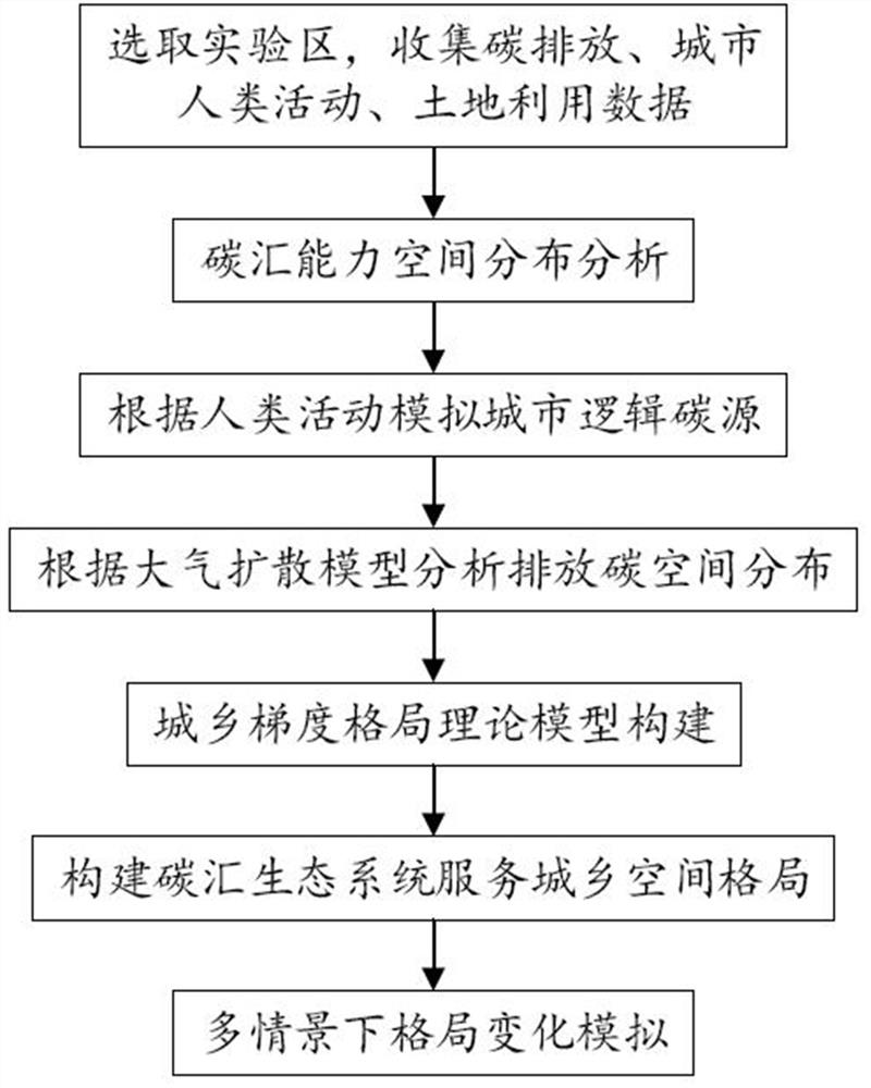
[0042] like figure 1 As shown, this embodiment provides an urban-rural gradient construction method of the ecological importance of carbon sinks, which includes the following steps:
[0043] 1. Select the experimental area and collect data on carbon emissions, urban human activities, and land use;
[0044] The collected data includes Landsat8 remote sensing data, POI (Point of Information) data, and annual energy consumption converted into standard coal.
[0045] 2. Spatial distribution analysis of carbon sink capacity;
[0046] Carbon sequestration types are divided into aboveground biomass carbon pools, underground biomass carbon pools, dead organic matter carbon pools, and soil organic matter carbon pools; each land use type contains 4 carbon pools, as shown in Table 1, through carbon density equivalent Calculation of carbon sinks;
[0047] Table 1 The carbon density equivalent of each land type of the four carbon pools (unit: kg / m 2 )
[0048]
[0049] Landsat8 rem...
Embodiment 2
[0073] This embodiment includes the following steps:
[0074] (1) Select the research area, prepare relevant data and data processing. There are many data acquisition and preprocessing methods, and this embodiment adopts common methods.
[0075] (a) Landsat8 remote sensing image data is classified by maximum likelihood method through envi5.3 platform.
[0076] (b) Use the urilib package of Python to capture all the location information of the research area from the POI interface of Baidu map. The json module is used to parse the returned data, and the csv module is used to store and manage the data. Since there are many captured data, time is required The module controls the script process to slow down the request frequency. Import to the ArcGIS platform, generate point shp files, and then correct the coordinates.
[0077] (c) Query the energy consumption data during the research period from the energy consumption statistical yearbook of the city's regional GDP included in ...
PUM
 Abstract
Description
Claims
Application Information
 - R&D
- Intellectual Property
- Life Sciences
- Materials
- Tech Scout
- Unparalleled Data Quality
- Higher Quality Content
- 60% Fewer Hallucinations
Browse by: Latest US Patents, China's latest patents, Technical Efficacy Thesaurus, Application Domain, Technology Topic, Popular Technical Reports.
© 2025 PatSnap. All rights reserved.Legal|Privacy policy|Modern Slavery Act Transparency Statement|Sitemap|About US| Contact US: help@patsnap.com


