Analysis method of line-of-sight coverage of civil aviation navigation equipment combined with flight trajectory and altitude
A technology of flight trajectory and navigation equipment, which is applied in the field of line-of-sight coverage analysis of civil aviation navigation equipment combined with flight trajectory and variable altitude, can solve problems such as inability to guarantee flight safety, and achieve the effect of ensuring flight safety, ingenious conception, and scientific design
- Summary
- Abstract
- Description
- Claims
- Application Information
AI Technical Summary
Problems solved by technology
Method used
Image
Examples
Embodiment 1
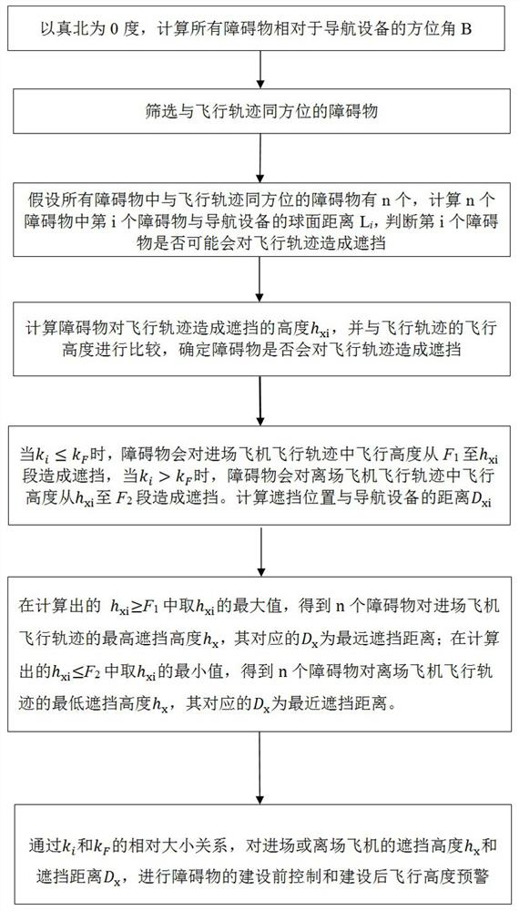
[0133] as attached Figure 5 As shown, the present invention provides an example of an airport applying the method of the present invention to perform line-of-sight coverage analysis, which specifically includes the following steps:
[0134] S1. Taking true north as 0 degrees, calculate the azimuth angle B of all obstacles relative to the navigation device, in degrees;
[0135] In the S1, the calculation formula of the azimuth angle B is:
[0136] B=90-A+360×T (1)
[0137] T=A / 360, rounded down (2)
[0138] A=atan2(x,y) , converted into an angle (3)
[0139] x = sin( O j - N j ) ×cos( O w ) (4)
[0140] y = cos( N w )×sin( O w )- sin( N w ) ×cos( O w ) ×cos( O j - N j ) (5)
[0141] in,( O w , O j ): the coordinates of the obstacle, where, O w is the latitude, O j is longitude;
[0142] ( N w , N j ) coordinates of the navigation device, where, N w is the latitude, N j is longitude.
[0143] S2. Screen the obstacles with the same orient...
example 1
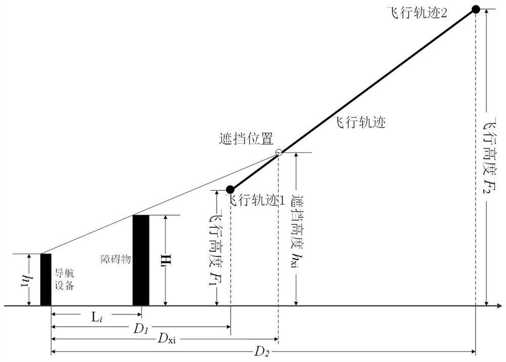
[0192] Example 1: Fθ=20°, h 1 = 100 meters, H i = 250 meters, F 1 = 300 meters, D 1 =2500m, F 2 = 900 meters, D 2 =6000m.
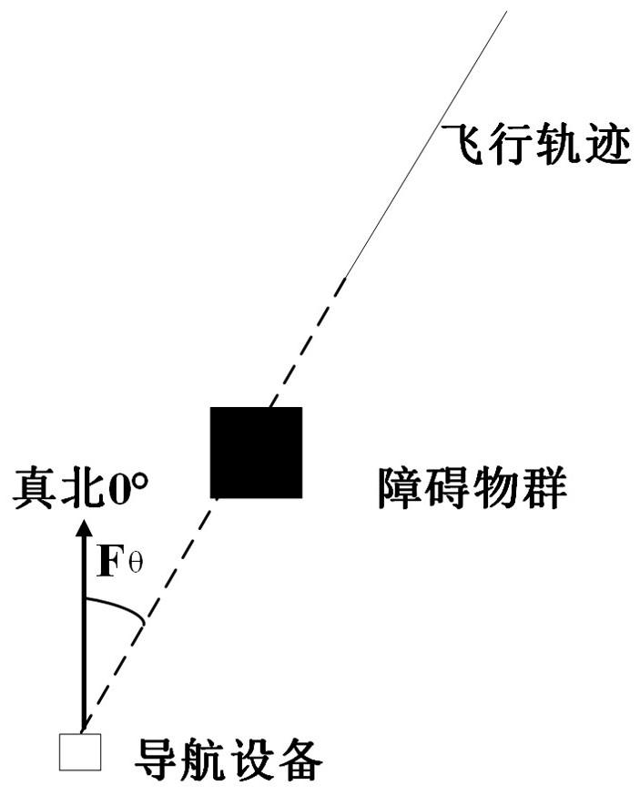
[0193] 1. Since the obstacle has a width, the azimuth range formed by the obstacle and true north is calculated according to the boundary of the obstacle. After calculation, the azimuth angles formed by the left and right boundaries of the obstacle and the true north are 11.90° and 21.5° respectively, so the azimuth angle of the obstacle ranges from 11.9° to 21.5°.
[0194] 2. Fθ is located in the range of the obstacle azimuth angle of 11.9°~21.5°. Therefore, the obstacle is in the same orientation as the flight trajectory.
[0195] 3. After calculation, the shortest distance L between the left and right boundaries of the obstacle and the navigation equipment i =1508m.
[0196] Satisfy 0 i D 2 , so it may occlude the flight path.
[0197] 4. After calculation, k i = 0.1, k F =0.17, k i k F , h xi = 416 meters, therefore, h xi > F ...
example 2
[0200] Example 2: Fθ=20°, h 1 = 100 meters, H i = 400 meters, F 1 = 600 meters, D 1 =2000m, F 2 = 900 meters, D 2 =6000m.
[0201] The azimuth angle formed by the connection line between the flight trajectory and the navigation device and true north is Fθ, the obstacle coordinates ( O w , O j ) and navigation device coordinates ( N w , N j ) does not change, therefore, the calculation process for determining whether the obstacle may block the flight trajectory in the first three steps is the same as that in Example 1, so it will not be repeated here, and the calculation will start from step 4 below.
[0202] 4. After calculation, k i =0.20, k F =0.075, k i > k F , h xi = 661 meters, therefore, h xi F 2 , the obstacle will block the flight height from 661 meters to 900 meters in the flight path, which is marked as a dashed line, and 600 meters to 661 meters without blocking, which is marked as a solid line.
[0203] 5. After calculation, the dista...
PUM
 Abstract
Description
Claims
Application Information
 - R&D
- Intellectual Property
- Life Sciences
- Materials
- Tech Scout
- Unparalleled Data Quality
- Higher Quality Content
- 60% Fewer Hallucinations
Browse by: Latest US Patents, China's latest patents, Technical Efficacy Thesaurus, Application Domain, Technology Topic, Popular Technical Reports.
© 2025 PatSnap. All rights reserved.Legal|Privacy policy|Modern Slavery Act Transparency Statement|Sitemap|About US| Contact US: help@patsnap.com


