
Satellite precipitation product space downscaling method based on water balance principle

A water balance and downscaling technology, which is applied in the field of satellite remote sensing data processing, can solve the problems of interpolation uncertainty, non-immediate response, and many missing values, and achieve high precision, avoid scaling effects and regression redundancy, and reduce deviations Effect

Active Publication Date: 2022-05-10
INST OF MOUNTAIN HAZARDS & ENVIRONMENT CHINESE ACADEMY OF SCI
View PDF10 Cites 2 Cited by
  • Summary
  • Abstract
  • Description
  • Claims
  • Application Information

AI Technical Summary

Problems solved by technology

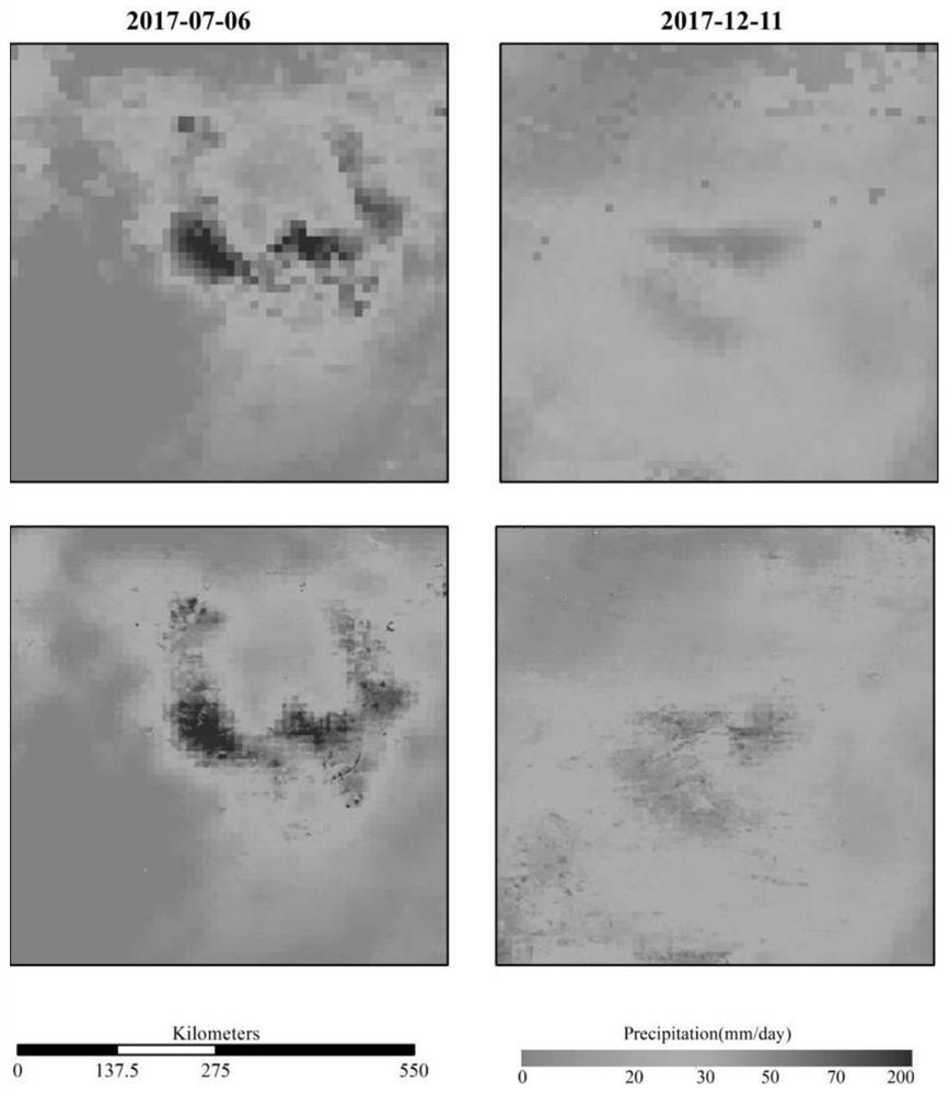
[0003]These satellite precipitation products all have a common problem, that is, the spatial resolution is very low, generally ranging from several kilometers to tens of kilometers, which limits their use in Applications in related research, the spatial downscaling method of satellite precipitation products is one of the effective means to improve the spatial resolution of satellite precipitation products. The selection of downscaling-related factors in many downscaling methods is mostly based on terrain factors and vegetation factors. These factors are related to precipitation The relationship between them is not an immediate response, and there is a certain degree of delay. The method is mainly based on statistical significance and lacks physical significance. The resolution (25km) is rarely considered as a key factor in the downscaling process of satellite precipitation products, and due to the large uncertainty in the occurrence of daily precipitation in the region, most downscaling methods only focus on the monthly and annual time scales , the accuracy is generally unsatisfactory on the diurnal scale
Moreover, the geographically weighted regression method in downscaling in the prior art is only a statistical method and does not involve physical meaning, and due to the scale effect, too many auxiliary regression factors are introduced, and the relationship between the downscaling regression factor used in the downscaling process and the precipitation The response effect is not immediately reflected. When calculating the optimal weight of each satellite in the high-resolution grid where the precipitation measurement site is located, it depends on the number of ground measurement sites. The interpolation weight process only contains mathematical meaning, and the interpolation has a great influence. Uncertainty

Method used


Image

  • Satellite precipitation product space downscaling method based on water balance principle
  • Satellite precipitation product space downscaling method based on water balance principle
  • Satellite precipitation product space downscaling method based on water balance principle

Examples


Embodiment Construction

[0040] The present invention will be further described now in conjunction with accompanying drawing.

[0041] see figure 1 , the present invention provides a method for spatial downscaling of satellite precipitation products based on the principle of water balance, comprising the following steps:

[0042] S1: Generation of surface soil moisture datasets associated with precipitation;

[0043] S2: Construction of precipitation estimation model based on water balance principle;

[0044] S3: Adaptive window fitting coefficient: The fitting coefficient obtained based on the adaptive window under the original GPM is applied to the high-resolution soil moisture and vegetation factors based on the water balance relation to obtain the spatial resolution without residual correction Rate 1km GPM data;

[0045] S4: Residual error correction based on Kriging interpolation: the 10km fitting residual data is interpolated to a spatial resolution of 1km using the weight-based Kriging inter...


PUM


Abstract

The invention relates to the technical field of satellite remote sensing data processing, in particular to a satellite precipitation product space downscaling method based on a water balance principle, which comprises the steps of precipitation correlation factor earth surface soil moisture data set generation, precipitation estimation model construction based on the water balance principle, and satellite precipitation product space downscaling. S3, applying a water balance relational expression to high-resolution soil moisture and vegetation factors to obtain a GPM which is not subjected to residual error correction and has the spatial resolution of 1km, interpolating 10km fitting residual error data to the spatial resolution of 1km by applying a weight Kriging interpolation method, and superposing the data obtained in the S3. Seamless high-spatial-resolution (1km) soil moisture data and vegetation factors NDVI are introduced in the downscaling method, excessive regression parameters are not introduced, the scale effect and regression redundancy among excessive data are avoided, a fitting relation is constructed based on a water balance equation, and large-area high-spatial-resolution rainfall data acquisition is achieved.

Description

technical field [0001] The invention relates to the technical field of satellite remote sensing data processing, in particular to a space downscaling method for satellite precipitation products based on the principle of water balance. Background technique [0002] With the continuous development of satellite remote sensing technology, because satellite precipitation products can provide continuous large-area coverage and long-term spatial coverage products, they are an important source of precipitation data for hydrological research in data-scarce areas, making up for ground stations and The lack of weather radar observations has been widely used in research in the fields of hydrology, ecology and climate change. [0003] These satellite precipitation products all have a common problem, that is, the spatial resolution is very low, generally ranging from several kilometers to tens of kilometers, which limits their application in related research. The spatial downscaling metho...

Claims


Application Information

Patent Timeline
Patent Type & Authority Applications(China)
IPC IPC(8): G06F17/18
CPCG06F17/18Y02A90/10
Inventor 赵伟何坤龙李召良段四波刘萌王永前
Owner INST OF MOUNTAIN HAZARDS & ENVIRONMENT CHINESE ACADEMY OF SCI
Learn More