An Adaptive Satellite Image Generation Method for UAV Visual Positioning

A satellite image and visual positioning technology, applied in the field of remote sensing images, can solve the problems of track offset, difference in scale between satellite images and UAV real images, and difficulty in adapting to changes in offline map libraries, achieving high consistency.

Active Publication Date: 2022-05-17
四川腾盾科技有限公司
View PDF0 Cites 0 Cited by
  • Summary
  • Abstract
  • Description
  • Claims
  • Application Information

AI Technical Summary

Problems solved by technology

In the current research on visual positioning, the generation of satellite images often relies on manual offline map capture. The offline map library prepared by this method is difficult to adapt to the changes encountered in the task process (such as UAV track change or track offset). )
[0008] 2. Differences in scale and other aspects between satellite images and UAV real-time images
The original satellite image is often quite different from the real image of the drone in terms of angle, field of view, scale, size, etc., and it is often impossible to obtain ideal matching results when performing image feature matching.

Method used


Image

  • An Adaptive Satellite Image Generation Method for UAV Visual Positioning
  • An Adaptive Satellite Image Generation Method for UAV Visual Positioning
  • An Adaptive Satellite Image Generation Method for UAV Visual Positioning

Examples


Embodiment Construction

[0057] The present invention will be further described in conjunction with the drawings and embodiments. Obviously, the described embodiments are only part of the embodiments of the present invention, not all of them. All other embodiments obtained by persons of ordinary skill in the art shall fall within the protection scope of the embodiments of the present invention.

[0058] see figure 1 , the present invention provides an embodiment of an adaptive satellite image generation method for unmanned aerial vehicle visual positioning, the method comprising:

[0059] S101: According to the current position estimation of the UAV, calculate the tile index number in the satellite map where the center point of the current real shot image of the UAV is located.

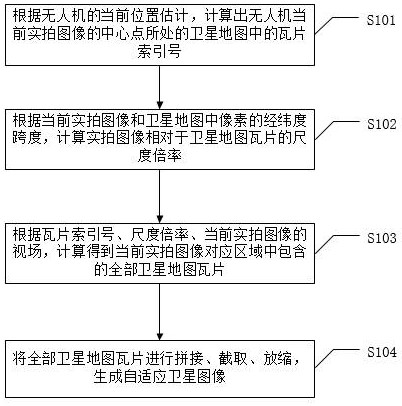
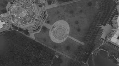
[0060] see figure 2 , which schematically shows a satellite map tile, see image 3 , which schematically gives a schematic diagram of the real image taken by the UAV.

[0061] S102: According to the latitude and longitud...


PUM


Abstract

The invention discloses an adaptive satellite image generation method for the visual positioning of a UAV, which includes: calculating the satellite map where the center point of the current real shot image of the UAV is located according to the current position estimation of the UAV The tile index number in the image; according to the latitude and longitude span of the pixels in the current real shot image and the satellite map, calculate the scale ratio of the real shot image relative to the satellite map tile; Field, calculate all the satellite map tiles contained in the corresponding area of ​​the current real shot image; splicing, intercepting, and zooming all the satellite map tiles to generate an adaptive satellite image. The invention can generate satellite images online in real time, and the generated satellite images have high consistency with real images in terms of field of view, angle, scale, size, etc., and can provide strong support for the global visual positioning algorithm of drones .

Description

technical field [0001] The invention relates to the technical field of remote sensing images, in particular to an adaptive satellite image generation method for visual positioning of drones. Background technique [0002] In recent years, with the rapid development of UAV-related industries, various types of UAVs have been widely used in civil or military fields such as aerial photography, telemetry, reconnaissance, and precision strikes. Under normal circumstances, UAVs rely on GPS signals for self-positioning, but UAVs often encounter situations where GPS signals are temporarily unavailable during missions, such as poor GPS signals in the area where UAVs are located or interference with GPS signals , in this case, the visual positioning method based on optical image matching can replace GPS to continuously provide positioning information for UAVs. [0003] Currently mainstream visual positioning methods such as ORB SLAM and VINS MONO are based on Visual Odometry (VO) or Vi...

Claims


Application Information

Patent Timeline
Patent Type & Authority Patents(China)
IPC IPC(8): G06F16/56G06F16/587G01C11/08G01C21/00
CPCG06F16/56G06F16/587G01C11/08G01C21/005
Inventor 徐宇夏炎杰陈姝婷王逸涛李嘉坤周永飞
Owner 四川腾盾科技有限公司
Why Eureka
Try Eureka