
Spatial distance prediction method and system based on image semantic segmentation network

A technology of semantic segmentation and spatial distance, applied in neural learning methods, biological neural network models, instruments, etc., can solve problems such as poor robustness and stability, and achieve strong robustness and improve accuracy.

Pending Publication Date: 2022-03-01
WUHAN ZHONGHAITING DATA TECH CO LTD
View PDF0 Cites 0 Cited by
  • Summary
  • Abstract
  • Description
  • Claims
  • Application Information

AI Technical Summary

Problems solved by technology

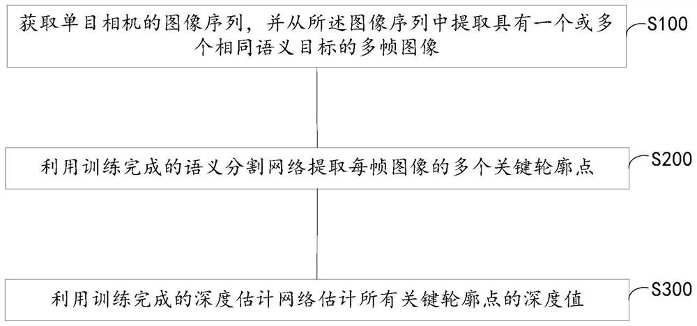
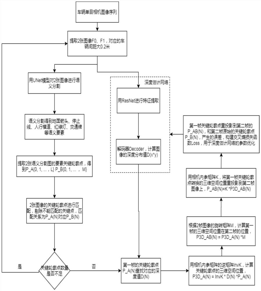
[0004] In order to solve the problem of poor robustness and poor stability of the three-dimensional space reconstruction of the local scene at the vehicle end, in the first aspect of the present invention, a spatial distance prediction method based on image semantic segmentation network is provided, including: acquiring the image sequence of the monocular camera , and extract multi-frame images with one or more identical semantic targets from the image sequence; use the trained semantic segmentation network to extract multiple key contour points of each frame image; use the trained depth estimation network to estimate all key points Depth value of contour point

Method used


Image

  • Spatial distance prediction method and system based on image semantic segmentation network
  • Spatial distance prediction method and system based on image semantic segmentation network
  • Spatial distance prediction method and system based on image semantic segmentation network

Examples


Embodiment 2

[0040] refer to Figure 4 , the second aspect of the present invention provides a spatial distance prediction system 1 based on an image semantic segmentation network, including: an acquisition module 11 for acquiring an image sequence of a monocular camera, and extracting a or multiple frames of images of the same semantic target; the extraction module 12 is used to utilize the trained semantic segmentation network to extract multiple key contour points of each frame image; the estimation module 13 is used to utilize the trained depth estimation network to estimate all The depth value of key contour points.

[0041] Further, the extraction module 12 includes a segmentation unit, an extraction unit and a matching unit, the segmentation unit is used to segment a plurality of semantic objects of each frame image using the Unet completed by training; the extraction unit is used to extract each A plurality of key contour points of a semantic target; the matching unit is used to m...

Embodiment 3

[0043] refer to Figure 5 , the third aspect of the present invention provides an electronic device, including: one or more processors; storage means for storing one or more programs, when the one or more programs are used by the one or more executed by one or more processors, so that the one or more processors implement the method of the first aspect of the present invention.

[0044] The electronic device 500 may include a processing device (such as a central processing unit, a graphics processing unit, etc.) 501, which may be loaded into a random access memory (RAM) 503 according to a program stored in a read-only memory (ROM) 502 or loaded from a storage device 508 Various appropriate actions and processing are performed by the program. In the RAM 503, various programs and data necessary for the operation of the electronic device 500 are also stored. The processing device 501 , ROM 502 and RAM 503 are connected to each other through a bus 504 . An input / output (I / O) int...


PUM


Abstract

The invention relates to a spatial distance prediction method and system based on an image semantic segmentation network, and the method comprises the steps: obtaining an image sequence of a monocular camera, and extracting a multi-frame image with one or more same semantic targets from the image sequence; extracting a plurality of key contour points of each frame of image by using the trained semantic segmentation network; and estimating depth values of all key contour points by using the trained depth estimation network. According to the method, the semantic segmentation network and the depth estimation network are combined to predict the spatial distance, map element three-dimensional space position information needed by mapping can be provided in real time, the robustness is high, the method is suitable for various scenes, and certain data integrity is reserved.

Description

technical field [0001] The invention belongs to the technical field of high-precision map making and deep learning, and specifically relates to a spatial distance prediction method and system based on an image semantic segmentation network. Background technique [0002] Autonomous driving requires high-precision maps as an aid for positioning, navigation, and planning, and high-precision maps require professional surveying and mapping vehicles for data collection, production and release. , to make up for the disadvantages of professional surveying and mapping vehicles. The core of vehicle-side local mapping lies in vehicle positioning and 3D reconstruction of map elements. [0003] Since the crowdsourcing map is fused by a large number of vehicle-side local maps, the spatial distance standard of each vehicle-side local map is not uniform, resulting in poor robustness and stability for 3D spatial reconstruction using traditional fusion methods. Contents of the invention ...

Claims


Application Information

Patent Timeline
Patent Type & Authority Applications(China)
IPC IPC(8): G06V10/26G06V10/46G06V10/82G06N3/04G06N3/08
CPCG06N3/08G06N3/045
Inventor 贾腾龙王小亮辛梓赵彦植
Owner WUHAN ZHONGHAITING DATA TECH CO LTD
Learn More