Distributed multi-level spatial indexing method for massive airborne laser point clouds

An airborne laser and laser point cloud technology, applied in the field of laser scanning measurement data processing, can solve the problems of incomplete and in-depth efficient management and processing of massive laser point clouds, and insufficient consideration of the characteristics of massive laser point clouds, and achieve powerful data Effects of storage management capabilities and computing capabilities, powerful storage management capabilities and computing capabilities, and efficient query and processing

Pending Publication Date: 2022-01-14
HUBEI UNIV OF TECH
View PDF0 Cites 3 Cited by
  • Summary
  • Abstract
  • Description
  • Claims
  • Application Information

AI Technical Summary

Problems solved by technology

However, in general, the current research on the efficient management and processing of massive laser point clouds in a distribute

Method used


Image

  • Distributed multi-level spatial indexing method for massive airborne laser point clouds
  • Distributed multi-level spatial indexing method for massive airborne laser point clouds
  • Distributed multi-level spatial indexing method for massive airborne laser point clouds

Examples


Embodiment Construction

[0050] The invention provides a distributed multi-level spatial indexing method for massive airborne laser point clouds, the method comprising the following steps:

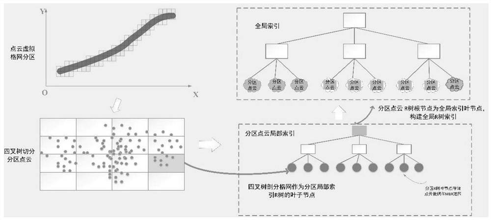
[0051] 1) Space division of laser point cloud based on virtual grid: According to the density of laser point cloud and the storage space occupied by a single point cloud data, determine the size of the virtual grid to ensure that a single HDFS file block can store laser points within the range of the virtual grid Cloud data and corresponding local index information. According to the laser point cloud coverage and the size of the virtual grid, the coverage of each laser point cloud partition is calculated, and the plane coordinates of the laser point cloud are used to realize the rapid division of the corresponding laser point cloud partitions.

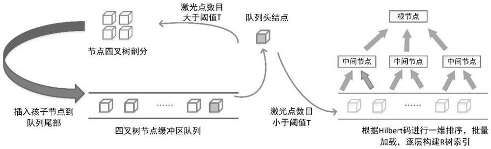
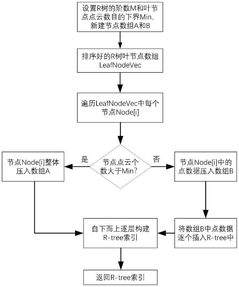
[0052] 2) Local index construction of laser point cloud partition based on quadtree and three-dimensional R tree; use quadtree to divide laser points in laser point cloud ...


PUM


Abstract

The invention belongs to the field of laser scanning measurement data processing, and relates to a distributed multi-level spatial indexing method for mass airborne laser point cloud, which comprises the following steps: 1) dividing a laser point cloud space based on a virtual grid to form laser point cloud partitions; 2) constructing a laser point cloud partition local index based on a quadtree and a three-dimensional R tree; and 3) taking a root node of the local index of each laser point cloud partition as a leaf node of a global spatial index, and establishing the global spatial index by using an STR tree. According to the distributed multi-level spatial indexing method for the massive airborne laser point clouds, distributed storage and efficient query and scheduling of the massive airborne laser point clouds on cluster nodes can be achieved.

Description

technical field [0001] The invention belongs to the field of laser scanning measurement data processing, and relates to a distributed multilevel spatial index method, in particular to a distributed multilevel spatial index method for massive airborne laser point clouds. Background technique [0002] Laser radar measurement technology (LiDAR) integrates high-precision 3D laser scanners, positioning and attitude determination systems, and high-definition digital cameras to achieve active measurement of the real environment through laser ranging. Compared with other traditional measurement methods, it has the advantages of high degree of automation, less affected by weather, short data production cycle, and high data accuracy. It can obtain high-precision three-dimensional space coordinate information and texture information in a large area, quickly and completely, which is the basis An important data source for facility construction engineering applications. [0003] However,...

Claims


Application Information

Patent Timeline
IPC IPC(8): G06F16/13G06F16/182G06F16/51
CPCG06F16/13G06F16/182G06F16/51
Inventor 吴颖丹吕辉田德生刘花璐胡在铭兰琰茜
Owner HUBEI UNIV OF TECH
Why Eureka
Try Eureka