Landslide collapse emergency evaluation method and system based on remote sensing big data
A big data and remote sensing technology, applied in data processing applications, machine learning, instruments, etc., can solve problems such as ineffective adjustment of rescue plans, and achieve strong macroscopic, rich information, and good timeliness
- Summary
- Abstract
- Description
- Claims
- Application Information
AI Technical Summary
Problems solved by technology
Method used
Image
Examples
Embodiment 1
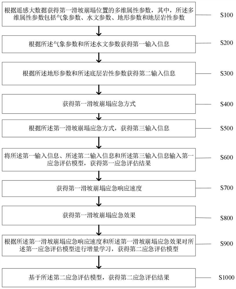
[0030] Such as figure 1 As shown, the embodiment of the present application provides a landslide and collapse emergency evaluation method based on remote sensing big data, wherein the method includes:
[0031] Step S100: Obtain the multi-dimensional attribute parameters of the first landslide collapse position according to the remote sensing big data, wherein the multi-dimensional attribute parameters include meteorological parameters, hydrological parameters, topographic parameters and formation lithology parameters;
[0032] Specifically, the multi-dimensional attribute parameters of the first landslide collapse location are obtained according to the remote sensing big data, wherein the remote sensing big data refers to the remote sensing data sets with typical big data characteristics obtained through various remote sensing technologies, and the common remote sensing Technologies include satellite remote sensing reconnaissance, aerial remote sensing, UAV remote sensing, etc...
Embodiment 2
[0089] Based on the same inventive concept as that of a landslide and collapse emergency evaluation method based on remote sensing big data in the foregoing embodiments, as Figure 8 As shown, the embodiment of the present application provides a landslide and collapse emergency evaluation system based on remote sensing big data, wherein the system includes:
[0090] The first obtaining unit 11, the first obtaining unit 11 is used to obtain the multidimensional attribute parameters of the first landslide collapse position according to the remote sensing big data, wherein the multidimensional attribute parameters include meteorological parameters, hydrological parameters, topographical parameters and formation lithology parameter;
[0091] A second obtaining unit 12, the second obtaining unit 12 is configured to obtain first input information according to the meteorological parameters and the hydrological parameters;
[0092] A third obtaining unit 13, the third obtaining unit ...
PUM
 Abstract
Description
Claims
Application Information
 - R&D
- Intellectual Property
- Life Sciences
- Materials
- Tech Scout
- Unparalleled Data Quality
- Higher Quality Content
- 60% Fewer Hallucinations
Browse by: Latest US Patents, China's latest patents, Technical Efficacy Thesaurus, Application Domain, Technology Topic, Popular Technical Reports.
© 2025 PatSnap. All rights reserved.Legal|Privacy policy|Modern Slavery Act Transparency Statement|Sitemap|About US| Contact US: help@patsnap.com


