Comprehensive visual picture layered fusion method
A fusion method and picture technology, which is applied in the field of layered fusion of comprehensive scenes and pictures to achieve the effect of solving the problem of occlusion
- Summary
- Abstract
- Description
- Claims
- Application Information
AI Technical Summary
Problems solved by technology
Method used
Image
Examples
Embodiment 1
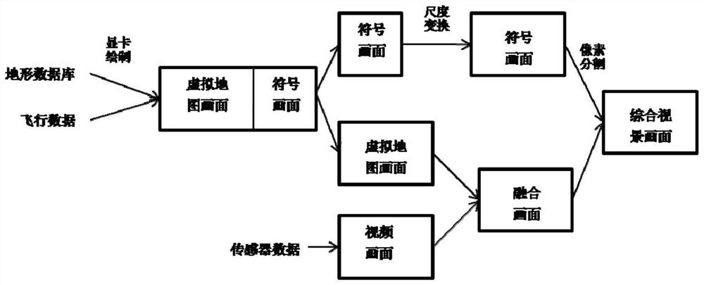
[0034] The present invention proposes a method for layered fusion of comprehensive visual images, the method flow is as follows figure 1 shown, including the following steps:
[0035] Step 101: Obtain a virtual map picture according to the terrain database and flight data, and draw the virtual map picture and the symbol picture in non-overlapping blocks to obtain a block drawing picture;
[0036] Specifically, in the first preset area, the virtual map picture is drawn according to a fixed resolution; in the second preset area, the symbol picture is drawn, and the first preset area and the second preset area do not overlap;
[0037] In practical applications, the overall display screen is divided left and right or up and down into a first preset area and a second preset area, the first preset area can be the left or right area of the overall display screen, and the second preset area can be The right or left area of the overall display screen, or the first preset area is t...
Embodiment 2
[0054] This solution proposes a layered fusion method of comprehensive visual images, which can solve the problem of fusion of different images of comprehensive visual images under a single graphics card, including three-layer images of virtual map images, symbol images and video images, such as figure 1 As shown, the process is as follows:
[0055] Step 201: First draw a virtual map screen and a symbol screen according to the terrain database and flight data, wherein the virtual map screen can have a fixed resolution of 1024*768, and the drawing position is on the left side of the output screen. According to the resolution of the output screen, such as 1900*1080, the symbol screen is drawn on the right side of the virtual map screen with the same height, and the width is the output screen width minus the fixed width of the virtual map screen, such as 1900-1024=876, which is used to display aircraft For related flight parameters, the background area can be set to black, and th...
PUM
 Abstract
Description
Claims
Application Information
 - R&D Engineer
- R&D Manager
- IP Professional
- Industry Leading Data Capabilities
- Powerful AI technology
- Patent DNA Extraction
Browse by: Latest US Patents, China's latest patents, Technical Efficacy Thesaurus, Application Domain, Technology Topic, Popular Technical Reports.
© 2024 PatSnap. All rights reserved.Legal|Privacy policy|Modern Slavery Act Transparency Statement|Sitemap|About US| Contact US: help@patsnap.com


