
FY-4 cloud wind guide estimation method and system based on TV_l1 optical flow method

A Fengyun-4, optical flow method, applied in the field of satellite remote sensing, can solve the problems of time resolution and calculation time lag, low spatial resolution, no product quality control scheme, etc., to overcome the difference between product time and space resolution. Effect

Pending Publication Date: 2021-10-22
NAT SATELLITE METEOROLOGICAL CENT
View PDF0 Cites 0 Cited by
  • Summary
  • Abstract
  • Description
  • Claims
  • Application Information

AI Technical Summary

Problems solved by technology

[0006] (1) The business cloud guide product uses a 5×5 or 7×7 sliding window area as the minimum search body, and the spatial resolution is relatively low (about 20km×20km);
[0007] (2) Three images are required to calculate one frame of wind guide products, and the time resolution and calculation time lag behind;
[0008] (3) There is no complete product quality control plan

Method used


Image

  • FY-4 cloud wind guide estimation method and system based on TV_l1 optical flow method
  • FY-4 cloud wind guide estimation method and system based on TV_l1 optical flow method
  • FY-4 cloud wind guide estimation method and system based on TV_l1 optical flow method

Examples


Embodiment 1

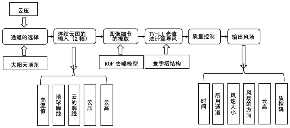
[0079] Such as figure 1 Shown, Embodiment 1 of the present invention provides based on TV_1 1 Fengyun-4 cloud guidance wind estimation method based on optical flow method.

[0080] Wind field estimation is simple in concept, but not easy to do accurately in practice. In order to calculate the wind vector well, the work of the other two links is also very important, these two links are data preprocessing and quality control. Therefore, the basic algorithm of satellite wind consists of five parts: data preprocessing, optical flow calculation, conversion of optical flow to wind field, height specification and quality control of tracer image blocks.

[0081] Step 1) Data preprocessing

[0082] Data preprocessing includes sensitive channel selection, file data extraction such as positioning and calibration, quality inspection, and fault-tolerant processing. Sensitive channel selection is to select data spectral channels that are sensitive to wind guidance from the original data...

Embodiment 2

[0163] Embodiment 2 of the present invention proposes a TV_1 based 1 Fengyun No. 4 cloud guiding wind estimation system based on the optical flow method, the system includes: a preprocessing module, an image decomposition module, an optical flow field calculation module, a wind vector calculation module, a cloud top height calculation module and a quality detection module; the specific processing is the same as in the embodiment 1, where

[0164] The preprocessing module is used to preprocess the two frames of satellite cloud images collected continuously by the Fengyun No. 4 meteorological satellite;

[0165] The image decomposition module is used to use the ROF image detail extraction model to decompose each preprocessed image to obtain corresponding basic images and detail images respectively;

[0166] The optical flow field calculation module is used to establish a pyramid structure for each frame of detail image, based on TV_1 1 The optical flow method iterates layer by...


PUM


Abstract

The invention discloses a FY-4 cloud wind guide estimation method and system based on a TV_l1 optical flow method. The method comprises the following steps: preprocessing two frames of satellite cloud pictures continuously acquired by a FY-4 meteorological satellite; adopting an ROF image detail extraction model to decompose each frame of image after preprocessing to obtain the corresponding basic images and detail images respectively; establishing a pyramid structure for each frame of detail image, performing layer-by-layer iteration according to the pyramid structure based on a TVl1 optical flow method, and performing calculation to obtain an optical flow field between the two frames of detail images; calculating a wind vector by combining the optical flow field with an earth projection model; calculating the height of the cloud top according to the standard atmosphere temperature low vertical profile table and the brightness temperature value of the cloud top; and carrying out quality detection on the wind vectors in combination with the cloud top height, rejecting unqualified wind vectors, and obtaining a wind vector field from all qualified wind vectors on the satellite cloud picture. According to the method, the precision of the cloud wind guide product is improved while the temporal-spatial resolution of the product is improved.

Description

technical field [0001] The present invention relates to the field of satellite remote sensing technology, in particular to 1 Fengyun-4 cloud guide wind estimation method and system based on optical flow method. Background technique [0002] Cloud guide wind is also called cloud trace wind, that is, the wind speed inferred from the movement of clouds. The cloud guide wind algorithm is based on two or three consecutive satellite cloud images taken by stationary meteorological satellites, tracking the movement of the same cloud block (target cloud or target cloud) on the image, and calculating the displacement of this characteristic cloud image, and at the same time calculating this The height level of a target cloud, so as to obtain the unconventional atmospheric wind that the cloud level causes the target cloud to move. The wind vector field composed of all atmospheric winds on the entire cloud map is called "cloud trail wind". [0003] Studies have shown that wind field d...

Claims


Application Information

Patent Timeline
Patent Type & Authority Applications(China)
IPC IPC(8): G06T7/269G01P5/00
CPCG06T7/269G01P5/001G06T2207/10032G06T2207/30192
Inventor 孙逢林覃丹宇李博陆其峰
Owner NAT SATELLITE METEOROLOGICAL CENT
Learn More