Earthwork calculation method based on unmanned aerial vehicle aerial survey technology

A calculation method and unmanned aerial vehicle technology, applied to the interpretation of photos, etc., can solve the problems of low measurement accuracy and precision, high measurement difficulty and safety risks, and high requirements for surveyors, and achieve risky field operations and image acquisition. Fast, high economic and social benefits

Inactive Publication Date: 2021-08-13
CHINA RAILWAY ERJU 1ST ENG
View PDF7 Cites 3 Cited by
  • Summary
  • Abstract
  • Description
  • Claims
  • Application Information

AI Technical Summary

Problems solved by technology

[0003] The invention provides an earthwork calculation method based on unmanned aerial vehicle aerial survey technology to solve the problems that traditional survey methods have high requirements for surveyors, difficult surveys, high safety risks, heavy workload, and low surveying accuracy and precision.

Method used


Image

  • Earthwork calculation method based on unmanned aerial vehicle aerial survey technology

Examples


Embodiment

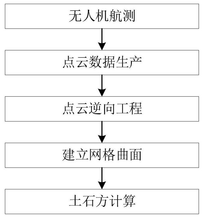
[0028] refer to figure 1 , this embodiment provides a method of earthwork calculation based on UAV aerial survey technology, the specific process is as follows:

[0029] 1) UAV aerial survey data collection

[0030] Choose weather with high visibility and low wind speed for aerial survey data collection.

[0031] In order to improve the accuracy of the aerial survey, it is necessary to arrange four image control points around the falling rocks. The coordinates of the center point can be measured directly by using on-site inkjet crosshairs, and the coordinate values ​​are converted into the WGS84-UTM coordinate system.

[0032] Adopt the manual flight acquisition mode, fly around the falling rocks, and collect image data from each position sequentially from bottom to top. The overlap rate between adjacent images must be guaranteed to be more than 80%, and the distance between the UAV’s aerial attitude and the target object must be guaranteed. Around 30m-50m.

[0033] 2) Poin...


PUM


Abstract

The invention provides an earthwork calculation method based on an unmanned aerial vehicle aerial survey technology, based on the technical thoughts of unmanned aerial vehicle aerial survey data collection, data processing, capacity calculation and the like, falling stone image data can be collected in a 360-degree all-around mode, a falling stone three-dimensional live-action model and a high-precision point cloud model are established, and based on reverse engineering of the point cloud data, the point cloud is converted into a three-dimensional curved surface model, the boundary of the model is sealed and closed through a curved surface, and the earthwork volume of rockfall is accurately calculated. The problems that a traditional measurement method is high in requirement for measurement personnel, large in measurement difficulty and safety risk, large in workload, low in measurement accuracy and precision and the like are solved. The invention belongs to the field of civil engineering.

Description

technical field [0001] The invention relates to an earthwork calculation method based on unmanned aerial vehicle aerial survey technology, which is particularly suitable for earthwork calculation of dangerous rockfall, borrow pits, accumulation bodies and other objects, and belongs to the field of civil engineering. Background technique [0002] At present, for the volume measurement of dangerous rockfall, GPS or total station is usually used to collect the ground point data of various parts on site, and import it into the South CASS software to produce 3D contour lines and calculate the amount of earth and stone. Because dangerous rockfalls are generally located in a relatively steep environment, the traditional measurement method has the following problems: there is a risk of collapse of the rockfall, it is difficult to ensure the safety of the on-site surveyors, the workload in the field is quite large, and the data of each characteristic part of the rockfall cannot be saf...

Claims


Application Information

Patent Timeline
Patent Type & Authority Applications(China)
IPC IPC(8): G01C11/34
CPCG01C11/34
Inventor 谢显龙胡光全阮忠栎何寿海谢能雍婷婷
Owner CHINA RAILWAY ERJU 1ST ENG
Why Eureka
Try Eureka