Unmanned aerial vehicle route planning method suitable for agricultural investigation

A route planning and unmanned aerial vehicle technology, applied in computer parts, instruments, characters and pattern recognition, etc., can solve the problems of environmental interference, different heights of trees, uneven distribution of field sizes, etc., to improve work efficiency, improve Universal effect

Pending Publication Date: 2021-08-10
NANTONG UNIVERSITY
View PDF0 Cites 3 Cited by
  • Summary
  • Abstract
  • Description
  • Claims
  • Application Information

AI Technical Summary

Problems solved by technology

[0004] 1. The field environment is complex: the distribution of rural buildings is relatively scattered, the network of utility poles and wires is intricate, the heights of trees are different, the network of rivers is densely covered, and the size of fields is unevenly distributed. data collection
[0005] 2. Complex and diverse crop planting: my country's current agriculture is generally in the mode of smallholder planting, using complex planting modes such as multiple cropping, intercropping, and interplanting. There are also characteristics of spatial diversity, dynamics, and seasonal variability in crop planting, which lead to fundamental uncertainty. Man-machine path planning is not suitable for agricultural census work
[0006] 3. Typical obstacle avoidance systems are not suitable for farmland operations: the principle of UAV obstacle avoidance technology is to judge the distance between obstacles and itself according to the sensors carried by the UAV, and then control the output of the motor to avoid obstacles
However, this method is susceptible to environmental interference and is only suitable for sensing short-distance obstacles

Method used


Image

  • Unmanned aerial vehicle route planning method suitable for agricultural investigation
  • Unmanned aerial vehicle route planning method suitable for agricultural investigation
  • Unmanned aerial vehicle route planning method suitable for agricultural investigation

Examples


Embodiment Construction

[0033] In order to make the purpose, technical solutions and advantages of the embodiments of the present invention clearer, the technical solutions in the embodiments of the present invention will be clearly and completely described below in conjunction with the drawings in the embodiments of the present invention. Obviously, the described embodiments It is a part of embodiments of the present invention, but not all embodiments. Based on the embodiments of the present invention, all other embodiments obtained by persons of ordinary skill in the art without making creative efforts belong to the protection scope of the present invention.

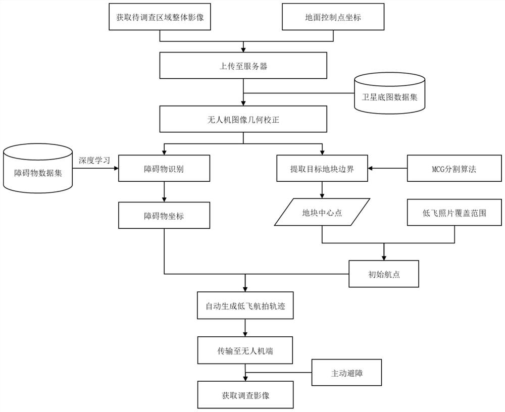
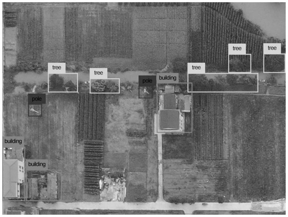
[0034] see Figure 1-Figure 3 , the present embodiment provides a route planning method for unmanned aerial vehicles suitable for agricultural surveys, including the following steps:

[0035] Step S1: Obtain the first image and the second image of the area to be investigated by the drone, and at the same time obtain the ground control point ...


PUM


Abstract

The invention discloses an unmanned aerial vehicle route planning method suitable for agricultural investigation; the method comprises the steps: firstly, obtaining an overall image, obtaining the coordinate information of a ground control point, carrying out the image geometric correction of high-resolution satellite remote sensing data and the aerial photo of an unmanned aerial vehicle in a high-flight to-be-investigated region; then inputting the corrected unmanned aerial vehicle aerial photo into a pre-trained YOLOv3 field obstacle recognition model to obtain an obstacle coordinate of the area, and using a multi-scale combination aggregation segmentation algorithm to realize field boundary automatic extraction; obtaining the central points of the field pieces by using the polygonal triangulation skeleton diagram, eliminating redundant central points of the field pieces according to the coverage range of pictures shot by the unmanned aerial vehicle, and generating an initial route; then, generating a buffer area in a certain range by taking the obstacle as the center, judging whether the initial waypoint is in the buffer area or not by adopting a ray guide method; finally, eliminating the waypoint in the buffer area, and generating a final route.

Description

technical field [0001] The invention relates to the field of UAV route planning, in particular to a UAV route planning method suitable for agricultural surveys. Background technique [0002] With the rapid development of my country's "smart agriculture", it will become an inevitable trend for agriculture to become intelligent and informatized. In recent years, the country has vigorously promoted the modernization of agriculture. With its unique advantages in flexibility, high resolution, and less affected by weather, drones have penetrated into all aspects of agricultural production. Compared with traditional remote sensing satellite image data, UAVs can carry out tasks in real time according to different agricultural needs and terrain characteristics, which solves the problems of complex data and scale sensitivity of remote sensing satellite images. [0003] However, in the actual UAV agricultural data collection, there are the following deficiencies: [0004] 1. The fiel...

Claims


Application Information

Patent Timeline
Patent Type & Authority Applications(China)
IPC IPC(8): G06K9/00G06K9/32G06K9/62G01C21/20
CPCG01C21/20G06V20/13G06V10/25G06V2201/07G06F18/214
Inventor 张慧芳王彬窈汤中港宜树华
Owner NANTONG UNIVERSITY
Why Eureka
Try Eureka