


Quick Research
Generate reliable direction feasibility study reports for your R&D in just a few steps.

Technical Q&A
Discover and master advanced knowledge NOW. Basics, ideas, possibilities, all at once.

Find Solutions
As an expert in R&D theories, this can generate solutions to your technical problems instantly.

Evaluate Feasibility
Analyze your overall solution with one click, know your potential R&D risks in advance.

Monitor Landscape
Get weekly tech updates, stay abreast of the latest tech innovations and key insights.
City operation simulation and overall planning system
A planning system and city technology, applied in image data processing, structured data retrieval, instruments, etc., can solve the problem of not being able to observe the city in multiple directions, and achieve the effect of improving the browsing speed
- Summary
- Abstract
- Description
- Claims
- Application Information
AI Technical Summary
Problems solved by technology
Method used
Image

Examples
Embodiment 1
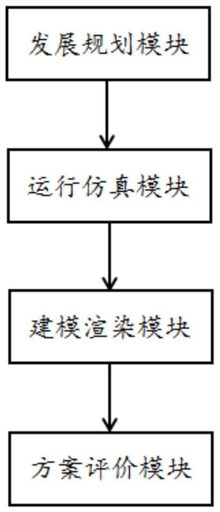
[0028] The embodiment is basically as attached figure 1 shown, including:
[0029] The development planning module is used to plan and design the development plan of urban construction;
[0030] The running simulation module is used to deduce the development plan based on the simulation model, and obtain the operation effect of the development plan in the city operation;
[0031] The modeling and rendering module is used to construct a 3D city virtual scene according to the development plan, seamlessly render the 3D city virtual scene in different regions according to the preset angle, and generate a multi-angle 3D map; cut the 3D map to obtain the cut map ; Carry out data encoding and organizational management on the cut map according to the angle, so that the three-dimensional map can be transformed from multiple angles to obtain the rendering effect;
[0032] The scheme evaluation module is used to evaluate the development scheme according to the operation effect and the ...
Embodiment 2
[0045] The only difference from Embodiment 1 is that the modeling and rendering module includes a display unit, which uses dynamic interactive technology to display the rendering effect in an all-round way, so that an immersive and all-round observation of the future city can be carried out. Under the premise of acceptable rendering error and good rendering effect, visually display the physical scene.
Embodiment 3
[0047] The only difference from Embodiment 2 is that the structure of the three-dimensional map is repaired. In this embodiment, the attitude information of pictures such as residential buildings and commercial buildings are obtained in advance according to the development plan of urban construction, for example, the information of various attitudes taken by these pictures; the specific process is as follows: first, the attitude information of these pictures is sparsely reconstructed , to obtain the sparse point cloud and the pose information of the picture; then, save the pose information of the picture, and re-establish a 3D map; then, obtain a snapshot of each picture based on the pose information of the picture, and form a set of picture pairs, that is, in In the reconstructed 3D map, the pose information of the sparsely reconstructed picture is used to construct the position of the camera, and the snapshots in the same pose are obtained through the camera. Each picture and...
PUM
 Abstract
Description
Claims
Application Information
 - R&D Engineer
- R&D Manager
- IP Professional
- Industry Leading Data Capabilities
- Powerful AI technology
- Patent DNA Extraction
Browse by: Latest US Patents, China's latest patents, Technical Efficacy Thesaurus, Application Domain, Technology Topic, Popular Technical Reports.
© 2024 PatSnap. All rights reserved.Legal|Privacy policy|Modern Slavery Act Transparency Statement|Sitemap|About US| Contact US: help@patsnap.com