Remote sensing image coastline extraction method based on deep semantic segmentation network

A technology of semantic segmentation and remote sensing images, applied in neural learning methods, biological neural network models, instruments, etc., can solve problems such as few remote sensing images, achieve enhanced coastline distribution characteristics, good effect, and improve extraction accuracy

Active Publication Date: 2021-07-20
SHANDONG UNIV OF SCI & TECH
View PDF7 Cites 5 Cited by
  • Summary
  • Abstract
  • Description
  • Claims
  • Application Information

AI Technical Summary

Problems solved by technology

Deep learning based on fully convolutional neural networks has achieved satisfactory performance in the fi...

Method used


Image

  • Remote sensing image coastline extraction method based on deep semantic segmentation network
  • Remote sensing image coastline extraction method based on deep semantic segmentation network
  • Remote sensing image coastline extraction method based on deep semantic segmentation network

Examples


Embodiment Construction

[0069] In order to more clearly illustrate the technical solutions in the embodiments of the present invention, the present invention will be further illustrated in conjunction with the accompanying drawings, and it is to be understood that these examples are intended to illustrate the scope of the invention, after reading the present invention. Those skilled in the art will belong to the scope of the present invention without all other embodiments obtained without creative labor.

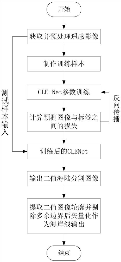
[0070] Such as figure 1 As shown, a remote sensing image coastline extraction method based on a depth semantic segmentation network, including the following steps: obtaining and preproving remote sensing images, making training samples, training coastline enhances semantic semantic split network (CLE-NET), calculates prediction during training The loss between the image and the label is then reversed. After the training is completed, the remote sensing image of the shoreline is required to enter the tr...


PUM


Abstract

The invention discloses a remote sensing image coastline extraction method based on a deep semantic segmentation network, and the method comprises the following steps: inputting a coastline training remote sensing image sample into an encoder, extracting low-level detail features and high-level semantic features, and obtaining a multi-level feature map; inputting the multi-level feature map into a decoder, and decoding the image through a shoreline enhancement fusion module and up-sampling + convolution operation to obtain a group of sea-land segmentation feature maps and a group of shoreline distribution feature maps; performing pixel-by-pixel prediction on the two groups of feature maps to obtain a sea-land segmentation binary image and a shoreline distribution binary image, and performing error back propagation by using a sea-land binary label and a shoreline label to obtain a trained network; inputting a coastal zone remote sensing image into the trained network to obtain a sea-land segmentation binary prediction image; and extracting a binary image contour as a sea-land boundary, removing useless boundaries, and vectorizing the sea-land boundary to obtain a coastline. According to the invention, the coastline distribution characteristics in the decoding process can be enhanced, and the coastline extraction precision is effectively improved.

Description

Technical field [0001] The present invention relates to the field of remote sensing image information, in particular to a remote sensing image coastline extraction method based on a depth semantic segmentation network. Background technique [0002] In recent years, with the rapid development of marine economy, human activities in the coastal belt are dense, the type and location of the coastline has undergone significant changes, and the coastal biodiversity is declining. The ecological environment has been seriously affected, and the coastline is rapidly and accurately extracts the coastal management. , Coastal change monitoring is of great significance. [0003] The coastline refers to the junction of land and the ocean. Due to the complex and diverse transition between the ocean and land, it is still a challenging issue from the remote sensing image. At present, remote sensing images have mainly have threshold segmentation methods, edge detection operator methods, object-orien...

Claims


Application Information

Patent Timeline
IPC IPC(8): G06K9/34G06K9/00G06K9/46G06N3/04G06N3/08
CPCG06N3/04G06N3/084G06V20/13G06V10/267G06V10/56Y02A10/40
Inventor 崔宾阁荆纬田远祥
Owner SHANDONG UNIV OF SCI & TECH
Why Eureka
Try Eureka