Eureka AIR delivers breakthrough ideas for toughest innovation challenges, trusted by R&D personnel around the world.

A UAV Meteorological Observation System

A technology of meteorological observation and unmanned aerial vehicles, applied in the field of meteorology, can solve the problems that it is difficult to achieve low-altitude horizontal long-distance, large area, fast observation and low-altitude vertical observation, limited data types and quantities, and poor observation effect, etc., to achieve Boundary layer meteorological environment monitoring, authenticity verification, and convenient operation

Active Publication Date: 2022-05-10
陕西省大气探测技术保障中心
View PDF0 Cites 0 Cited by
  • Summary
  • Abstract
  • Description
  • Claims
  • Application Information

AI Technical Summary

Problems solved by technology

[0004] However, due to the limitations of the UAV model, the existing systems using UAVs for meteorological observations make it difficult to achieve low-altitude, horizontal, long-distance, large-area, fast observation and low-altitude vertical observation, and short-distance, small-area, and low-speed observations. Taking into account the horizontal observation, resulting in poor observation effect
[0005] Moreover, the existing systems using UAVs for meteorological observations are limited by the carrying capacity and processing power of a single UAV, resulting in limited data types and quantities, which are difficult to meet the needs of current meteorological observations

Method used


Image

  • A UAV Meteorological Observation System
  • A UAV Meteorological Observation System
  • A UAV Meteorological Observation System

Examples


Embodiment Construction

[0035] The present invention will be further described below in conjunction with the accompanying drawings and examples, and the contents of the examples are not intended to limit the protection scope of the present invention.

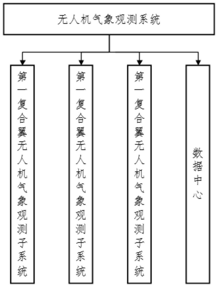
[0036] The invention relates to an unmanned aerial vehicle meteorological observation system, which is an unmanned aerial vehicle observation system based on multiple combinations and observation methods of a compound-wing unmanned aerial vehicle (one master and one backup) and a multi-rotor unmanned aerial vehicle. Low-altitude horizontal long-distance, large-area, and fast observation can also realize low-altitude vertical observation and short-distance small-area low-speed horizontal observation, making observation more comprehensive and better.

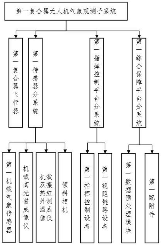
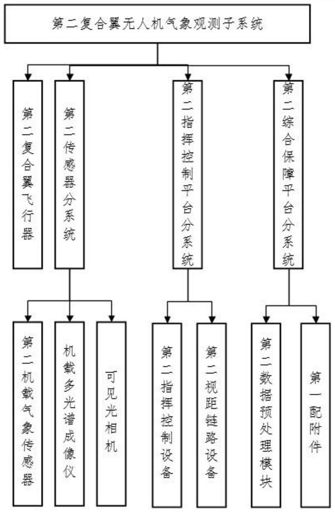
[0037] figure 1 A schematic diagram of the composition of the UAV meteorological observation system of the present invention is shown. Such as figure 1 As shown, the UAV weather observation system of the...


PUM


Abstract

The present invention relates to a UAV weather observation system, comprising a first compound-wing UAV weather observation subsystem, a second compound-wing UAV weather observation subsystem, a multi-rotor UAV weather observation subsystem and a data center, Each meteorological observation subsystem has aircraft, sensor subsystem, command and control platform subsystem and integrated support platform subsystem. It is an unmanned aerial vehicle observation system based on multiple combinations and observation methods, which can realize high-definition resolution detection of disaster-stricken areas, make up for the shortcomings of existing satellite remote sensing in disaster prevention and mitigation, and more efficiently play the role of meteorology in disaster prevention and mitigation. Benefits: Realize ecological meteorological remote sensing monitoring in different topography and climate zones, realize land surface ecosystem observation and evaluation, and provide guidance for the construction of ecological civilization such as soil erosion in the Loess Plateau and water conservation land in Qinling Mountains; realize the authenticity of satellite ground products Calibration; realize boundary layer meteorological environment monitoring, and carry out boundary layer haze research.

Description

technical field [0001] The invention belongs to the technical field of meteorology, and relates to a meteorological observation system, in particular to an unmanned aerial vehicle meteorological observation system. Background technique [0002] Currently, meteorological observations mainly rely on satellite remote sensing systems. However, due to the influence of satellite distribution, satellite observation accuracy and satellite detection ability, the existing satellite remote sensing system has many defects in disaster prevention and mitigation. [0003] With the development of drone technology, some people began to use drones for meteorological observations to make up for the defects caused by relying solely on satellite remote sensing systems. [0004] However, due to the limitations of the UAV model, the existing systems using UAVs for meteorological observations make it difficult to achieve low-altitude, horizontal, long-distance, large-area, fast observation and low...

Claims


Application Information

Patent Timeline
Patent Type & Authority Patents(China)
IPC IPC(8): G01W1/08G01W1/06G05D1/08G05D1/10
CPCG01W1/08G01W1/06G05D1/0808G05D1/101
Inventor 李成伟毛峰刘佳奇徐颂捷夏江峰孟珍李伟孟超龙亚星苏静
Owner 陕西省大气探测技术保障中心
Why Eureka
Eureka Blog
Learn More