
Positioning method and system for airport ground service vehicle

A positioning method and airport technology, which is applied to the positioning method and system field of airport ground service vehicles, can solve the problem of low availability of vehicle integrated navigation algorithms, and achieve the effect of strong ability and improved positioning accuracy

Inactive Publication Date: 2021-06-25
NINGXIA UNIVERSITY
View PDF5 Cites 0 Cited by
  • Summary
  • Abstract
  • Description
  • Claims
  • Application Information

AI Technical Summary

Problems solved by technology

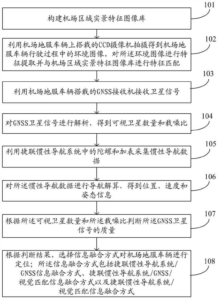
[0003] The purpose of the present invention is to provide a positioning method and system for airport ground service vehicles, using strapdown INS, GNSS and visual matching combination technology to improve the accuracy and robustness of airport ground service vehicle positioning, and realize airport ground service vehicle positioning. Real-time positioning of vehicles, which solves the problem of low availability of vehicle-mounted integrated navigation algorithms for airport ground service vehicles in the prior art

Method used


Image

  • Positioning method and system for airport ground service vehicle
  • Positioning method and system for airport ground service vehicle
  • Positioning method and system for airport ground service vehicle

Examples


Embodiment Construction

[0050] The following will clearly and completely describe the technical solutions in the embodiments of the present invention with reference to the accompanying drawings in the embodiments of the present invention. Obviously, the described embodiments are only some, not all, embodiments of the present invention. Based on the embodiments of the present invention, all other embodiments obtained by persons of ordinary skill in the art without making creative efforts belong to the protection scope of the present invention.

[0051]Among the many navigation systems, inertial navigation and satellite navigation are two commonly used systems. GNSS is a reference system and INS is a dead reckoning system. The error law of the satellite navigation and positioning system is opposite to that of the inertial navigation system. Due to its wavelength, it is easily affected by electromagnetic wave transmission, weather, etc., and each positioning has a certain error, but the positioning erro...


PUM


Abstract

The invention discloses a positioning method and system for an airport ground service vehicle. A fusion algorithm and a navigation working mode can be intelligently switched by utilizing GNSS, strapdown INS and a visual matching technology aiming at a special environment of a strong electromagnetic field of an airport. Compared with other simple combination modes, navigation information resources are more fully utilized, the capacity of adapting to the special electromagnetic environment of the airport is high, and more humanization and autonomy are achieved. The problems that strapdown INS positioning errors accumulate along with time and strapdown INS cannot work independently for a long time, and GNSS satellites excessively depend on satellite signals are solved. The positioning precision of the airport ground service vehicle can be improved, and seamless positioning is realized.

Description

technical field [0001] The invention relates to the field of integrated navigation, in particular to a positioning method and system for airport ground service vehicles. Background technique [0002] There is strong electromagnetic interference in the airport area, which is bound to have an impact on GNSS (Global Navigation Satellite System) signals. The hidden dangers of electromagnetic interference to airport safety cannot be ignored. Due to the three major vulnerabilities of spoofing, interference and occlusion in GNSS in the airport environment, even if the receiver can lock the GNSS satellite signal, it often shows problems such as low signal-to-noise ratio, multiple gross errors, fixed ambiguity errors, and multiple cycle slips. , At the same time, there are multipath effects, which will increase the difficulty of data processing, and GNSS cannot provide continuous positioning services in complex environments. Strapdown INS (inertial navigation system) is an independe...

Claims


Application Information

Patent Timeline
Patent Type & Authority Applications(China)
IPC IPC(8): G01S19/47
CPCG01S19/47
Inventor 刘伟铭李超超钱学武沈翔季鲁敏刘建国高乾于亦龙葛飞许永涛文张建王怀康
Owner NINGXIA UNIVERSITY
Learn More