


Quick Research
Generate reliable direction feasibility study reports for your R&D in just a few steps.

Technical Q&A
Discover and master advanced knowledge NOW. Basics, ideas, possibilities, all at once.

Find Solutions
As an expert in R&D theories, this can generate solutions to your technical problems instantly.

Evaluate Feasibility
Analyze your overall solution with one click, know your potential R&D risks in advance.

Monitor Landscape
Get weekly tech updates, stay abreast of the latest tech innovations and key insights.
Map framing method and system based on road side unit, equipment and storage medium
A roadside unit and map technology, applied in geographic information databases, special data processing applications, structured data retrieval, etc., can solve the problems of redundant road information and inapplicability, achieve concise map information, reduce bandwidth burden, and ensure timeliness effect
- Summary
- Abstract
- Description
- Claims
- Application Information
AI Technical Summary
Problems solved by technology
Method used
Image

Examples
Embodiment 1
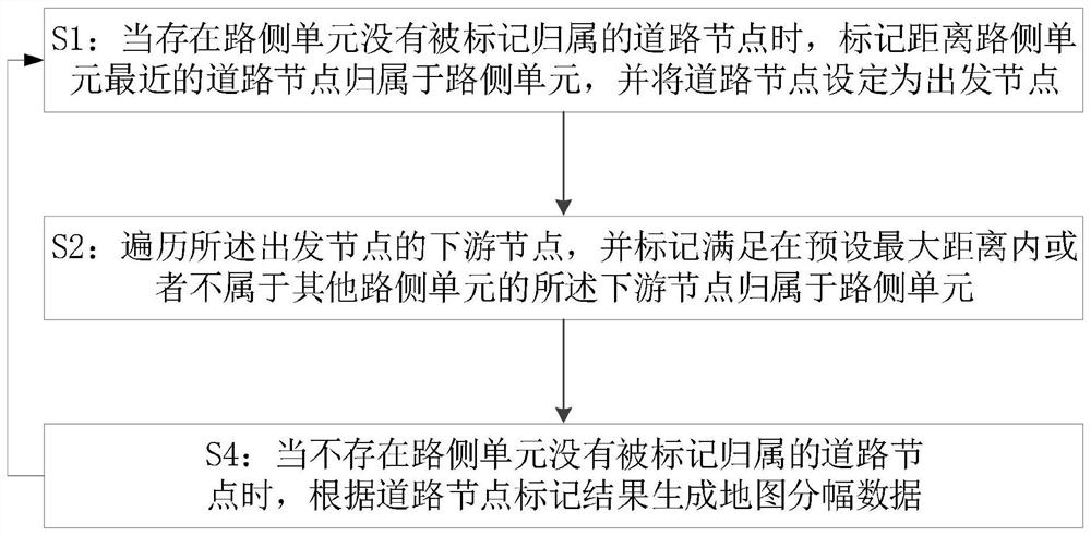
[0046]Such asfigure 1 As shown, this embodiment provides a way of road-side unit map sharing method, including:
[0047]S1: When there is a road node that is not marked attributed road side units, the labeled road node is attributed to the road side unit, and sets the road node as a starting node;
[0048]S2: Travel the downstream node of the departure node, and mark the downstream node satisfying within the preset maximum distance or not belonging to other road side units belongs to the road side unit;
[0049]S4: When there is no road node without marking the home side unit, the map sharing data is generated according to the road node tag results, and returns to S1.
[0050]In the traditional map, a rectangular display or latitude is generally used, and the map is cut into a fixed-size rectangular area or an approximate trapezoidal area, but the map transmission method cannot meet the actual needs of the vehicle network, on the one hand, the road side unit To the vehicle broadcasting the map ...
Embodiment 2
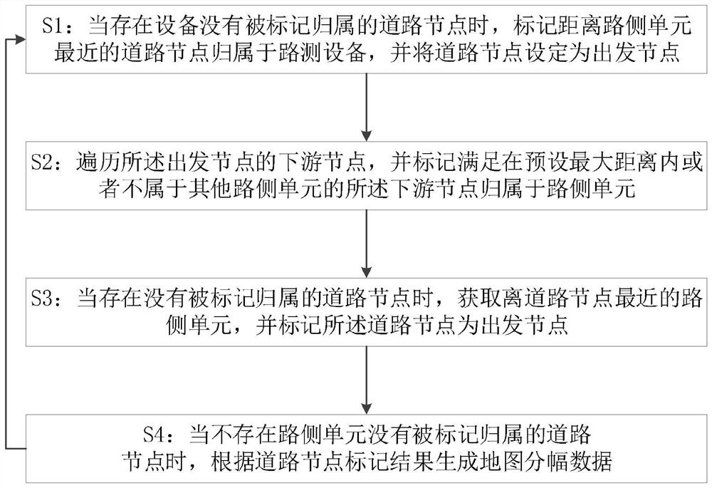
[0055]Such asfigure 2 As shown, this embodiment provides a way of road-side unit map sharing method, including:
[0056]S1: When there is a road node that is not marked attributed road side units, the labeled road node is attributed to the road side unit, and sets the road node as a starting node;
[0057]S2: The downstream node of the departure node is trailed to the downstream node satisfying or not in the preset maximum distance or not belonging to other road side units belongs to the road side unit; the traversal is based on a deep traversal method;
[0058]S3: When there is a road node that is not marked attributed road side unit, the road side unit closest to the road node is obtained, and the road node is marked as a starting node;
[0059]S4: When there is no road node that is not marked attributed road side units, the map sharing data is generated according to the road node tag results, and returns to S1;
[0060]In Example 1, there is a case, that is, although all road side units have su...
Embodiment 3
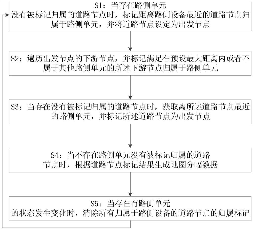
[0068]Such asimage 3 As shown, this embodiment provides a way of road-side unit map sharing method, including:
[0069]S1: When there is a road node that is not marked attributed road side units, the labeled road node is attributed to the road side unit, and sets the road node as a starting node;
[0070]S2: Travel the downstream node of the departure node, and mark the downstream node satisfying within the preset maximum distance or not belonging to other road side units belongs to the road side unit;
[0071]S3: When there is a road node that is not marked attributed road side unit, the road side unit closest to the road node is obtained, and the road node is marked as the starting node and returns to S2;
[0072]S4: When there is no road node that is not marked attributed road side units, the map sharing data is generated according to the road node mark;
[0073]S5: When there is a change in the state of the road side unit, all the home flags of the road nodes that are attributed to the road si...
PUM
 Abstract
Description
Claims
Application Information
 - R&D Engineer
- R&D Manager
- IP Professional
- Industry Leading Data Capabilities
- Powerful AI technology
- Patent DNA Extraction
Browse by: Latest US Patents, China's latest patents, Technical Efficacy Thesaurus, Application Domain, Technology Topic, Popular Technical Reports.
© 2024 PatSnap. All rights reserved.Legal|Privacy policy|Modern Slavery Act Transparency Statement|Sitemap|About US| Contact US: help@patsnap.com