
Pile foundation burying depth determination method based on BIM technology

A technique for determining the depth of soil and its determination method, which can be used in foundation structure tests, foundation structure engineering, construction, etc., and can solve problems such as inability to generate models, difficulty in supporting layer models, and difficulty in ensuring model quality

Inactive Publication Date: 2021-04-02
CHINA 19TH METALLURGICAL CORP
View PDF9 Cites 5 Cited by
  • Summary
  • Abstract
  • Description
  • Claims
  • Application Information

AI Technical Summary

Problems solved by technology

In this technology, there are certain problems in the generation method of the bearing layer, that is, it needs to use the Revit plug-in Dynamo to program, the programming has a high threshold, and it must be operated by professionals, and the technical personnel on the construction site of the project generally do not have Programming ability, there are certain difficulties in generating the bearing layer model by this method
[0005] CN202010404314 discloses a pile length estimation method based on BIM model, which uses the "building floor" function of Revit2016 software to establish a bearing layer model, but the "building floor" function is only applicable to the situation where the surface of the bearing layer is relatively flat. It is difficult to ensure the quality of the model when dealing with complex formations with large ups and downs, and it is even impossible to generate the model
[0006] CN201911125705 discloses a fusion method of geological survey map and pile foundation map based on the Revit platform. In the process of expanding the original drilling data with the cubic spline surface modeling method, programming is also required, which requires high technical personnel , difficult to be implemented by technicians at the construction site

Method used


Image

  • Pile foundation burying depth determination method based on BIM technology
  • Pile foundation burying depth determination method based on BIM technology
  • Pile foundation burying depth determination method based on BIM technology

Examples


Embodiment Construction

[0030] The present invention will be further described below in conjunction with the accompanying drawings and embodiments.

[0031] The method for determining the burial depth of pile foundation based on BIM technology of the present invention comprises the following steps:

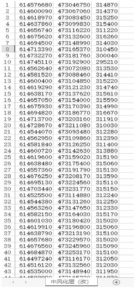
[0032] A. According to geological exploration data, organize the three-dimensional coordinate information of each exploration point on the bearing layer interface into a *.csv file. The specific geological exploration process is a commonly used existing technology. Through drilling and measuring at multiple exploration points, the three-dimensional coordinate information at each exploration point can be obtained, and the csv file can be obtained by summarizing the three-dimensional coordinate information. This step is mainly When it comes to data summarization, ordinary people can complete it. Some screenshots of the summarized csv file are as follows figure 1 shown.

[0033] B. Generate a surface in C...


PUM


Abstract

The invention provides a BIM technology-based pile foundation penetration depth determination method. The method comprises the steps of arranging three-dimensional coordinate information of each exploration point of a bearing stratum interface into a csv file; generating a curved surface in Civil 3d, defining the curved surface by using the *.csv file obtained in the step A, generating a three-dimensional geologic model taking a supporting layer interface as an upper surface by applying a command of 'extracting from the curved surface', and exporting an ACIS entity, namely a .sat file; inserting the .sat file and the made pile foundation model project file into Revit software, and integrating a pile foundation and a supporting layer model; counting the length of each pile after the pile end is integrated to the surface of the supporting layer to generate a pile foundation detail list; and obtaining the buried depth of each pile on the basis of the length of the pile in the pile foundation detail list and the depth of the pile tip entering the supporting layer in the design file. The method is convenient and rapid, only simple mouse and keyboard operation is needed, complex programming learning is not needed, general construction site technicians can learn rapidly, and the method has generalizability in a project site.

Description

technical field [0001] The invention relates to the technical field of pile foundation construction, in particular to a method for determining the depth of pile foundation based on BIM technology. Background technique [0002] In the process of pile foundation construction, it is often encountered that the pile length needs to be determined according to the position of the bearing layer. The traditional method is to judge the position of the bearing layer based on the stratum thickness information of each vertical section obtained from the geological exploration points, and combine the requirements of the depth of the pile tip into the bearing layer in the design documents to calculate the reasonable length of the pile, and obtain the pile foundation depth of penetration. To determine the depth of the pile foundation, two values ​​need to be determined first, one is the required value in the design document for the depth of the pile foundation entering the bearing layer, wh...

Claims


Application Information

Patent Timeline
Patent Type & Authority Applications(China)
IPC IPC(8): G06F30/13G06T17/05E02D27/12E02D33/00
CPCG06F30/13G06T17/05E02D27/12E02D33/00
Inventor 胡念三代权刘斌李强谷昌满
Owner CHINA 19TH METALLURGICAL CORP
Learn More