Navigation map construction method for three-dimensional reconstruction of visual fusion information

A navigation map and image fusion technology, applied in the field of three-dimensional reconstruction navigation map, can solve the problems of incomplete and accurate perception of multi-source information features, unmanned devices and personnel safety threats, etc., and achieve the goal of enhancing three-dimensional feature information and enriching environmental information Effect

Pending Publication Date: 2021-03-09
WUHAN SECOND SHIP DESIGN & RES INST
View PDF16 Cites 2 Cited by
  • Summary
  • Abstract
  • Description
  • Claims
  • Application Information

AI Technical Summary

Problems solved by technology

However, abnormally high temperature areas and high radiation dose areas are common in nuclear power and search and rescue environments, which pose a huge security threat to unmanned devices and personnel entering the environment to perform tasks. Navigation maps constructed only by geometric boundary environmental information cannot obtain temperature , dose and other non-visible light field information, unable to completely and accurately perceive the characteristics of multi-source information in the environment

Method used


Image

  • Navigation map construction method for three-dimensional reconstruction of visual fusion information
  • Navigation map construction method for three-dimensional reconstruction of visual fusion information
  • Navigation map construction method for three-dimensional reconstruction of visual fusion information

Examples


Embodiment Construction

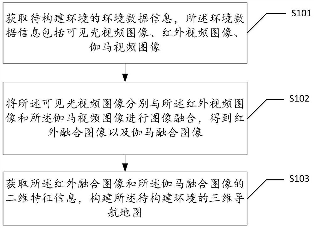
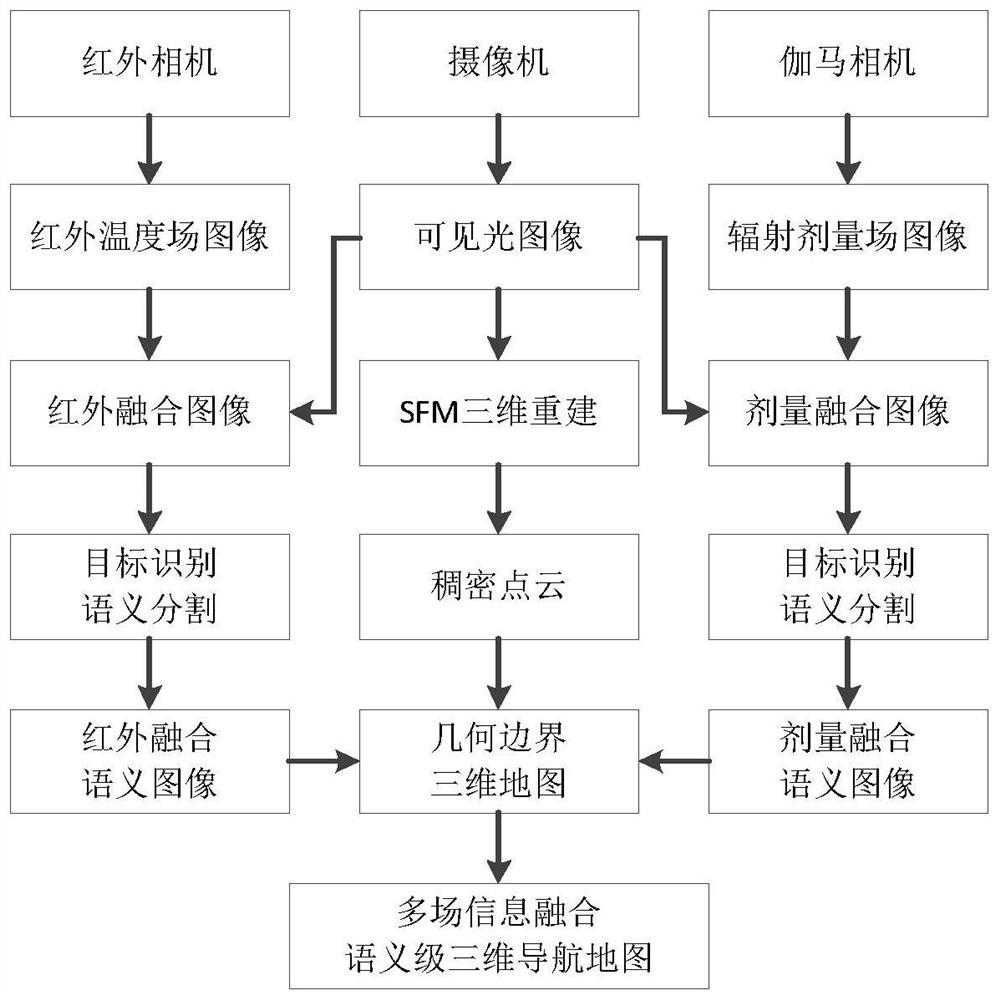
[0024] The technical solutions in the embodiments of the present application will be clearly and completely described below in conjunction with the drawings in the embodiments of the present application.

[0025] In the following introduction, the terms "first" and "second" are only used for the purpose of description, and should not be understood as indicating or implying relative importance. The following description provides multiple embodiments of the present invention, and different embodiments can be replaced or combined in combination, so the present invention can also be considered to include all possible combinations of the same and / or different embodiments described. Thus, if one embodiment contains features A, B, C, and another embodiment contains features B, D, then the invention should also be considered to include all other possible combinations containing one or more of A, B, C, D Although this embodiment may not be clearly written in the following content.

[...


PUM


Abstract

The invention discloses a navigation map construction method for three-dimensional reconstruction of visual fusion information. The method comprises the steps of obtaining environment data informationof a to-be-constructed environment, wherein the environment data information comprises a visible light video image, an infrared video image and a gamma video image; respectively carrying out image fusion on the visible light video image, the infrared video image and the gamma video image to obtain an infrared fusion image and a gamma fusion image; and acquiring two-dimensional feature informationof the infrared fusion image and the gamma fusion image, and constructing a three-dimensional navigation map of the to-be-constructed environment. Semantic segmentation and target recognition are carried out on information such as an infrared field and a gamma dose field in an image and a three-dimensional scene, semantic-level feature information is added to a map, and information support is provided for mobile equipment to quickly recognize target features in the map.

Description

technical field [0001] The present application relates to the technical field of three-dimensional reconstructed navigation maps, in particular, to a navigation map construction method for three-dimensional reconstruction of visual fusion information. Background technique [0002] Unmanned devices can provide live maps of the scene during operation and maintenance tasks and emergency handling tasks, which is of great significance in application scenarios such as nuclear power environments and search and rescue environments. The existing related navigation map construction methods have defects in non-visible light field information and map construction in unknown environments. At present, the relatively mature instant positioning and map construction (Simultaneous Localization and Mapping, SLAM) method mainly relies on lidar to detect visible physical obstacles. Objects are measured to realize the geometric boundary environment information of the navigation map. However, abn...

Claims


Application Information

Patent Timeline
Patent Type & Authority Applications(China)
IPC IPC(8): G06T17/20G06T17/05G06T5/50G06K9/34
CPCG06T17/20G06T17/05G06T5/50G06T2200/04G06T2207/10028G06T2207/20221G06V10/267
Inventor 冯毅周宏宽刘伟邱志强柯志武陶模陈朝旭李献领郑伟柯汉兵魏志国戴春辉劳星胜柳勇肖颀
Owner WUHAN SECOND SHIP DESIGN & RES INST
Why Eureka
Try Eureka