Ccultivated land quality grade evaluation method based on remote sensing index

A technology of quality level and evaluation method, applied in the direction of image data processing, data processing applications, instruments, etc., can solve the problems of cumbersome monitoring process, time-consuming, and labor-consuming, and achieve saving manpower and material resources, high reliability, and simple method Effect

Inactive Publication Date: 2021-02-05
福州福大经纬信息科技有限公司
View PDF4 Cites 0 Cited by
  • Summary
  • Abstract
  • Description
  • Claims
  • Application Information

AI Technical Summary

Problems solved by technology

But there are the following deficiencies: 1. Based on the traditional evaluation method of cultivated land quality grade, it is time-consuming and labor-intensive, and the monitoring results are discontinuous in time and space
2. There are many researches on county-based index inversion methods based on remote sensing methods, but there are few studies on city-level and above, and the inversion accuracy needs to be improved
3. Both of the above two methods have problems such as cumbersome monitoring process

Method used


Image

  • Ccultivated land quality grade evaluation method based on remote sensing index
  • Ccultivated land quality grade evaluation method based on remote sensing index
  • Ccultivated land quality grade evaluation method based on remote sensing index

Examples


Embodiment Construction

[0036] In order to make the features and advantages of this patent more obvious and easy to understand, the following special examples are described in detail as follows:

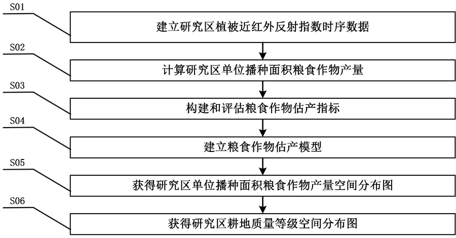
[0037] like figure 1 As shown, the remote sensing index-based cultivated land quality grade evaluation method provided in this embodiment includes the following steps:

[0038] Step S01: Establish time-series data of vegetation near-infrared reflectance index in the study area:

[0039] The 8-day maximum synthetic time-series data set of the near-infrared emission index of the vegetation in the study area was established pixel by pixel. The Whittaker Smoother smoothing method was used to smooth the original 8-day maximum synthetic vegetation near-infrared emission index multi-year time-series data, so as to obtain multi-year smooth daily vegetation near-infrared emission index time-series data sets pixel by pixel.

[0040] Step S02: Calculate the yield of grain crops per unit sown area in the study area. ...


PUM


Abstract

The invention provides a cultivated land quality grade evaluation method based on a remote sensing index. The method comprises the following steps: S1, establishing vegetation near-infrared reflectionindex time series data of a research area; S2, calculating the grain crop yield per unit seeding area of the research area; S3, selecting grain crop yield estimation indexes; S4, establishing a graincrop yield estimation model; S5, obtaining a spatial distribution diagram of the grain crop yield per unit seeding area of the research area; and S6, obtaining a cultivated land quality grade spatialdistribution map of the research area. The method is simple and easy to operate and high in result accuracy, and can be well applied to large-scale cultivated land quality grade evaluation.

Description

technical field [0001] The invention belongs to the technical field of agricultural remote sensing monitoring, and in particular relates to a method for evaluating cultivated land quality grades based on remote sensing indices. Background technique [0002] Cultivated land resources are the basis for ensuring food production and safety, and an important guarantee for ensuring sustainable economic development. Protecting arable land resources has a positive effect on social stability and people's quality of life. In recent decades, population growth and economic development have put increasing pressure on land resources, land degradation (such as soil erosion, soil fertility decline), and high-quality cultivated land have been occupied in large quantities. A big problem facing development. Therefore, how to quickly and accurately locate the dynamic changes of regional cultivated land quality is of great significance to grasp the dynamics of cultivated land quality, promote t...

Claims


Application Information

Patent Timeline
Patent Type & Authority Applications(China)
IPC IPC(8): G06Q10/06G06Q50/02G06T7/62
CPCG06Q10/06393G06Q10/06395G06Q50/02G06T7/62G06T2207/10032G06T2207/10048G06T2207/30188
Inventor 李海文蔡圣准闫超
Owner 福州福大经纬信息科技有限公司
Why Eureka
Try Eureka