High-rise fire-fighting multi-unmanned aerial vehicle cooperative path planning method in urban block environment

An urban block and multi-UAV technology, which is applied in the direction of finding targets and other directions, can solve problems such as unreasonable paths and inability to cope with the complex and changeable flight environment of urban blocks, and achieve reasonable path planning, high safety, and response speed. quick effect

Pending Publication Date: 2021-02-05
GUANGDONG UNIV OF TECH
View PDF6 Cites 5 Cited by
  • Summary
  • Abstract
  • Description
  • Claims
  • Application Information

AI Technical Summary

Problems solved by technology

[0004] In order to overcome the unreasonable path planned by the existing method and the inability to cope with the complex and changeable flight environment of urban blocks, the present invention provides a collaborative path planning method for high-rise firefighting and multi-UAVs in the urban block environment

Method used


Image

  • High-rise fire-fighting multi-unmanned aerial vehicle cooperative path planning method in urban block environment
  • High-rise fire-fighting multi-unmanned aerial vehicle cooperative path planning method in urban block environment
  • High-rise fire-fighting multi-unmanned aerial vehicle cooperative path planning method in urban block environment

Examples


Embodiment 1

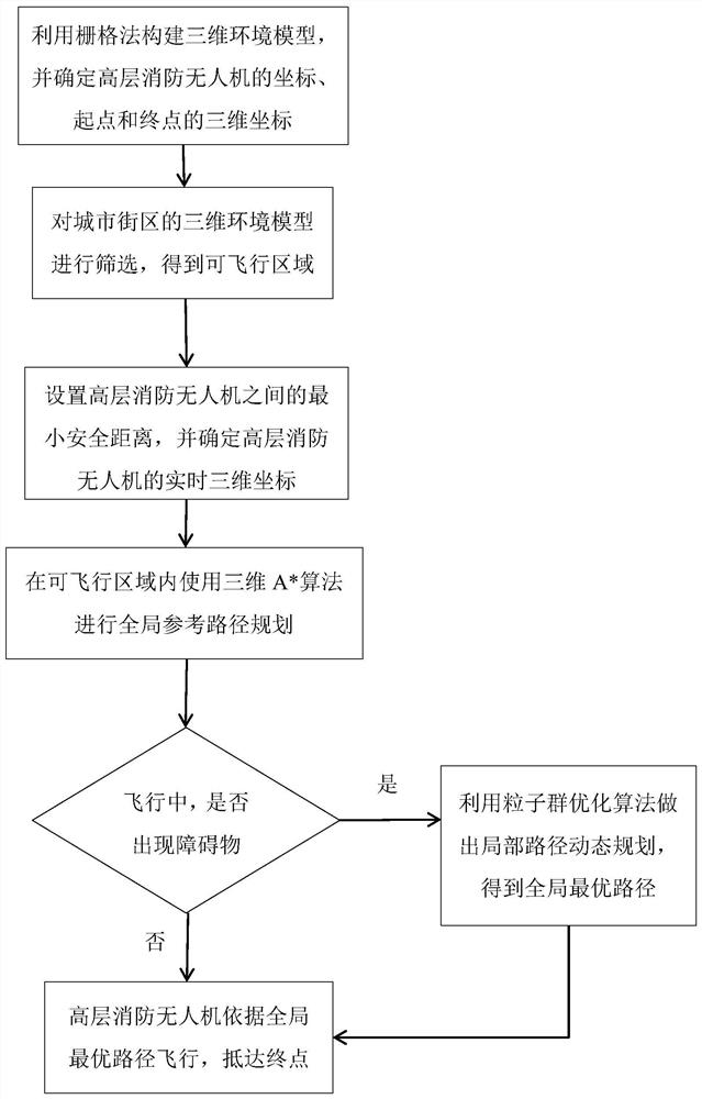
[0049]This embodiment provides a method for collaborative path planning of high-rise firefighting multiple drones in an urban block environment, such asfigure 1 As shown, the method includes the following steps:

[0050]S1: Use the grid method to construct a three-dimensional environment model of the city block. In the three-dimensional environment model, set the coordinates of the high-level fire-fighting drone as D(x,y,z), and the attitude information as D(θ,ψ), where θ is the pitch angle of the high-level fire-fighting drone, and ψ is the heading angle of the high-level fire-fighting drone; in the three-dimensional environment model, determine the three-dimensional coordinates of the starting point and the end point of the high-level fire drone;

[0051]S2: Screen the three-dimensional environment model to obtain a flightable area including the start and end points of the high-rise fire drone;

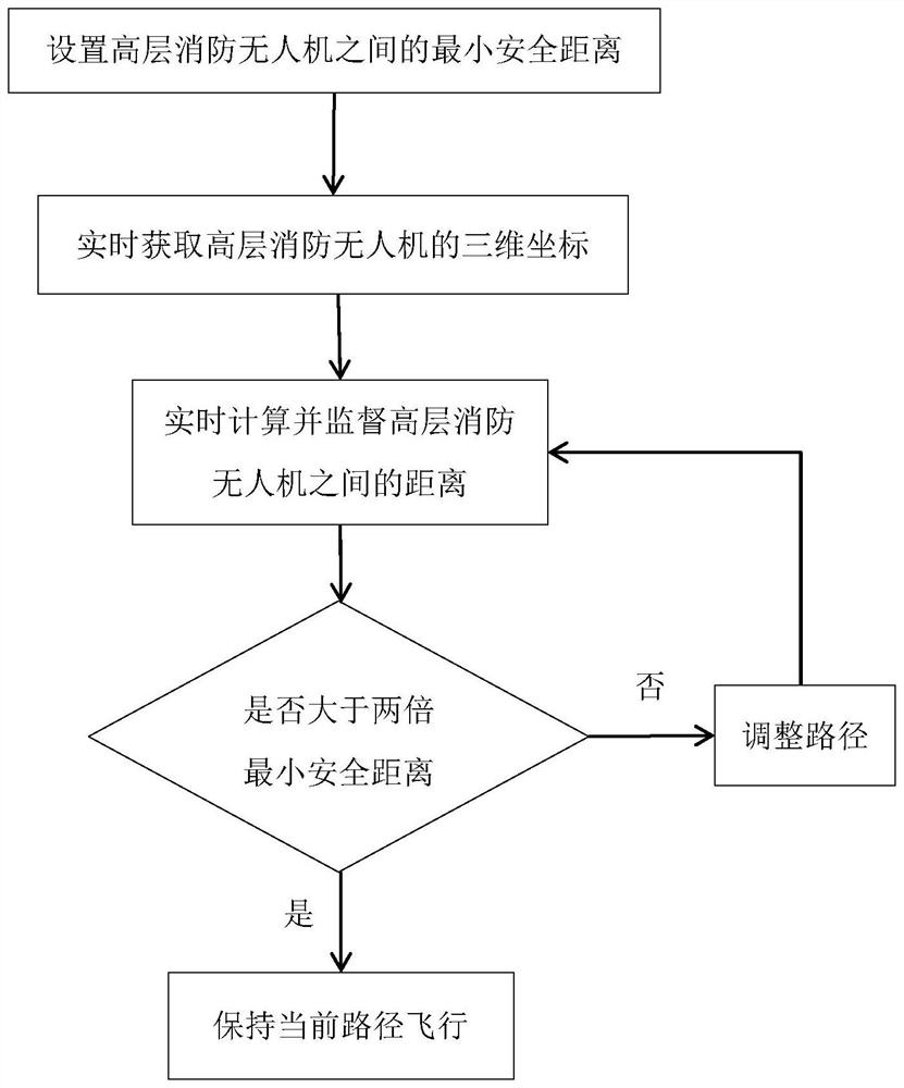
[0052]S3: Set the minimum safety distance between high-rise fire drones, denoted as dsafe , So...


PUM


Abstract

The invention discloses a high-rise fire-fighting multi-unmanned aerial vehicle cooperative path planning method in an urban block environment, and the method comprises the steps: building a three-dimensional environment model of an urban block through employing a grid method, and screening the three-dimensional environment model, and obtaining a flying region; searching and screening a flying area by using a three-dimensional A * algorithm, and planning a global reference path; using a sensor carried by the high-rise fire-fighting unmanned aerial vehicle for collecting environment informationin real time and updating the three-dimensional environment model in real time, carrying out online local path planning through a particle swarm optimization algorithm, determining whether an unknownobstacle appears on a current path or not, and determining whether the high-rise fire-fighting unmanned aerial vehicle needs dynamic obstacle avoidance or not. In addition, by setting the minimum safety distance, cooperative flight of the multiple high-rise fire-fighting unmanned aerial vehicles is achieved. According to the method, cooperative path planning and autonomous flight of the high-risefire-fighting unmanned aerial vehicle are realized by using a hybrid algorithm, the path planning is reasonable, the response speed is high, obstacles are flexibly avoided in the flight process, andhigher safety is achieved.

Description

Technical field[0001]The invention relates to the field of UAV path planning, and more specifically, to a method for collaborative path planning of high-rise firefighting multiple UAVs in an urban block environment.Background technique[0002]The number of high-rise buildings in my country ranks among the top in the world, but the high-rise buildings are densely populated and combustible, resulting in frequent high-rise building fire accidents. In order to protect people's livelihood, economy, and safeguard the safety of people's lives and property, the state attaches great importance to the fire protection of high-rise buildings, and encourages the use of emerging intelligent equipment such as firefighting drones to play a role in disaster relief and other fields. When a high-rise building catches fire, the traditional fire-fighting modes and equipment face difficulties in space, time and operation, and the fire-fighting drone can be dispatched quickly and reach the fire floor in the...

Claims


Application Information

Patent Timeline
Patent Type & Authority Applications(China)
IPC IPC(8): G05D1/12
CPCG05D1/12
Inventor 李鸿一于跃飞任鸿儒鲁仁全姚得银
Owner GUANGDONG UNIV OF TECH
Why Eureka
Try Eureka