Eight-rotor-wing unmanned aerial vehicle surveying and mapping device for natural resource investigation

A technology of natural resources and surveying and mapping devices, applied in the field of drones, can solve problems such as drone or camera damage, drone flight instability, etc., to improve reliability and safety, improve lifting stability, and improve stability sexual effect

Inactive Publication Date: 2021-01-12
安徽同绘家园土地信息技术有限公司
View PDF6 Cites 0 Cited by
  • Summary
  • Abstract
  • Description
  • Claims
  • Application Information

AI Technical Summary

Problems solved by technology

UAV aerial photography surveying and mapping completes the work through the camera. Generally, shooting from different angles is completed by rotating the fixed frame of the camera in order to obtain more realistic image data. However, during the process of rotating the fixed frame of the camera, drones may fly The problem of instability, and the drone will be subject to a large impact when it lands, which may cause damage to the drone or camera

Method used


Image

  • Eight-rotor-wing unmanned aerial vehicle surveying and mapping device for natural resource investigation
  • Eight-rotor-wing unmanned aerial vehicle surveying and mapping device for natural resource investigation
  • Eight-rotor-wing unmanned aerial vehicle surveying and mapping device for natural resource investigation

Examples


Embodiment 1

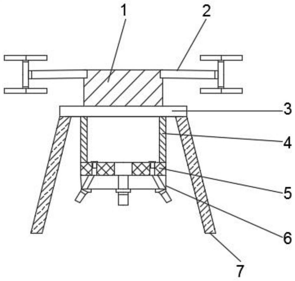
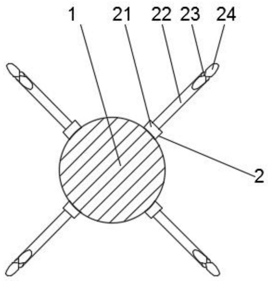
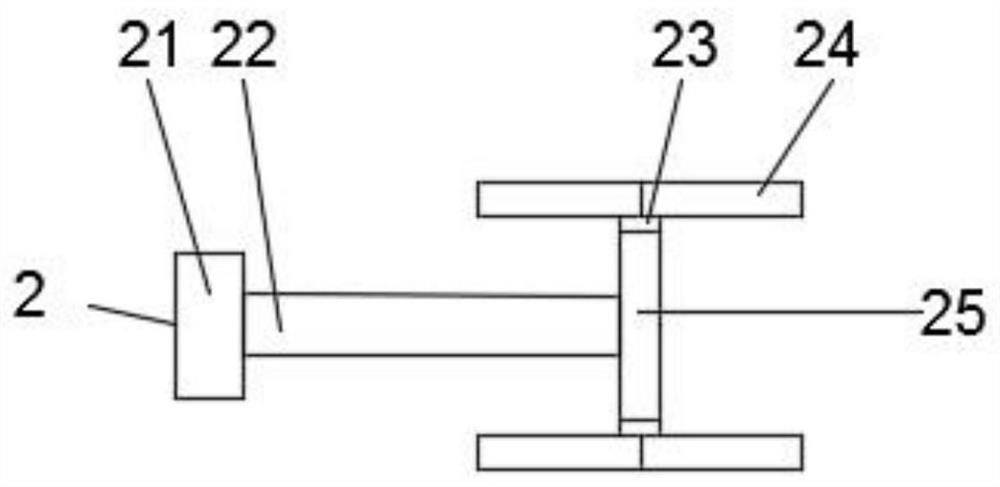
[0033] During the use of the present invention, four groups of rotor mechanisms 2 are installed near the upper end of the outer surface of the drone body 1, and the four groups of rotor mechanisms 2 are arranged in an equidistant manner. The rotor mechanisms 2 include a protective shaft tube 21 and a rotor shaft rod 22. , rotating shaft 23, rotor blade 24 and fixed shaft tube 25, one end of protection shaft tube 21 is connected with the outer surface of drone body 1, and the other end of protection shaft tube 21 is connected with rotor shaft 22 and fixed shaft tube 25 , the rotor shaft 22 is located on the side of the fixed shaft tube 25 close to the drone body 1, one end of the rotor shaft 22 penetrates into the inside of the protection shaft tube 21, and the inside of the fixed shaft tube 25 is equipped with a rotating shaft 23, the rotating shaft Both ends of the rod 23 penetrate to the outside of the fixed shaft tube 25, and the two ends of the rotating shaft 23 are equippe...


PUM


Abstract

The invention discloses an eight-rotor-wing unmanned aerial vehicle surveying and mapping device for natural resource investigation. The eight-rotor-wing unmanned aerial vehicle surveying and mappingdevice comprises an unmanned aerial vehicle body, rotor wing mechanisms, a base, a first connecting plate, a second connecting plate, a drawing and surveying fixing mechanism and a supporting mechanism. According to the unmanned aerial vehicle, through the arrangement of the rotor wing blades, the lifting stability of the unmanned aerial vehicle body is greatly improved; by arranging a second plotting and measuring camera body and a first plotting and measuring camera body, the plotting and measuring range is wider, the plotting and measuring efficiency of a user is improved, the problem thatplotting and measuring can be conducted in a wider range only by rotating the plotting and measuring fixing mechanism is solved, the plotting and measuring fixing mechanism does not need to be rotated, and the overall stability of the device is improved; the drawing and measuring fixing mechanism is prevented from being abraded due to rotation, and the service life of the drawing and measuring fixing mechanism is prolonged; and through the arranged supporting mechanism, the damping and buffering effects of the device are improved, so that the overall stress of the device is more uniform, and the reliability and safety of the device are improved.

Description

technical field [0001] The invention relates to the technical field of unmanned aerial vehicles, in particular to an eight-rotor unmanned aerial vehicle surveying and mapping device for natural resource investigation. Background technique [0002] Surveying and mapping refers to surveying and drawing. Based on computer technology, photoelectric technology, network communication technology, space science, and information science, with global navigation satellite positioning system, remote sensing, and geographic information system as the technical core, the existing feature points on the ground are And the boundary line obtains the graphics and position information reflecting the current situation of the ground by means of measurement, which is used for the planning, design and administrative management of engineering construction. Generally speaking, it refers to the shape, size, spatial position and attributes of natural geographical elements or surface artificial facilities...

Claims


Application Information

Patent Timeline
Patent Type & Authority Applications(China)
IPC IPC(8): B64C27/10B64C25/64B64D47/08
CPCB64C27/10B64C25/64B64D47/08B64U2101/30B64U10/10
Inventor 徐天锋金德喜方亮刘成扩吴凡许志圣杨明徐华君付婷婷宋超江波
Owner 安徽同绘家园土地信息技术有限公司
Why Eureka
Try Eureka