
Scenic spot vehicle and ship monitoring system based on GIS map and various positioning

A GIS map and monitoring system technology, applied in the direction of collaborative devices, character and pattern recognition, instruments, etc., can solve problems such as ineffective positioning, complex environmental conditions in scenic spots, and weak GPS signals, so as to improve tourism experience and increase Effects of coverage and life extension

Active Publication Date: 2021-01-01
成都中科大旗软件股份有限公司
View PDF10 Cites 0 Cited by
  • Summary
  • Abstract
  • Description
  • Claims
  • Application Information

AI Technical Summary

Problems solved by technology

The basis for the effective management of sightseeing cars and cruise ships is to accurately locate them. The existing positioning methods are usually based on the GPS system. However, the environmental conditions of scenic spots are usually complicated. In many places, the GPS signal is weak and cannot be effectively positioned.
In addition, some roads in the scenic area are narrow and only one car is allowed to pass through. How to effectively dispatch and avoid two cars facing each other on the narrow road at the same time causing traffic jams is also a direction worth studying.

Method used


Image

  • Scenic spot vehicle and ship monitoring system based on GIS map and various positioning
  • Scenic spot vehicle and ship monitoring system based on GIS map and various positioning
  • Scenic spot vehicle and ship monitoring system based on GIS map and various positioning

Examples


Embodiment Construction

[0045] The technical solutions of the present invention will be clearly and completely described below in conjunction with the embodiments. Apparently, the described embodiments are only some of the embodiments of the present invention, not all of them. Based on the embodiments of the present invention, all other embodiments obtained by those skilled in the art without making creative efforts belong to the protection scope of the present invention.

[0046] refer to Figure 1-3 , the present invention provides a scenic vehicle and ship monitoring system based on GIS maps and various positioning:

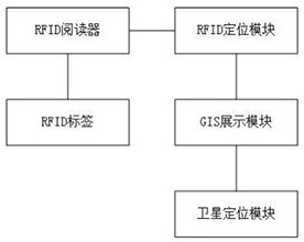
[0047] Such as figure 1 As shown, the scenic vehicle and ship monitoring system based on GIS map and multiple positioning includes RFID tags, RFID readers, RFID positioning modules, satellite positioning modules and GIS display modules.

[0048] The shown RFID tag is installed on a fixed facility in the scenic spot to store first information, the first information includes the inst...


PUM


Abstract

The invention discloses a scenic spot vehicle and ship monitoring system based on a GIS map and multiple kinds of positioning, and the system comprises: an RFID tag which is used for storing first information which comprises the installation position information of the RFID tag; a RFID reader which is used for reading the first information of the RFID tag and generating second information, whereinthe second information comprises the first information and the signal intensity corresponding to the RFID tag when the RFID reader reads the first information; a RFID positioning module which is usedfor calculating the position information of the scenic spot vehicles and ships according to the second information; a satellite positioning module which is used for acquiring position information ofvehicles and ships in the scenic area by utilizing a satellite positioning system when the RFID positioning module fails to position; and a GIS display module which is used for displaying the positioninformation of the scenic spot vehicles and ships on a GIS map. Positioning of vehicles and ships in scenic spots is realized on the basis of RFID and a satellite positioning system, corresponding positioning modes are selected according to different conditions, and the problem of inaccurate positioning of a single GPS is solved.

Description

technical field [0001] The invention belongs to the technical field of scenic spot safety monitoring, in particular to a scenic spot vehicle and ship monitoring system based on GIS maps and multiple positioning. Background technique [0002] With the improvement of people's living standards, more and more people go out to travel. At the same time, in order to accommodate more tourists, the scale of scenic spots is also expanding. In order to improve people's travel experience in scenic spots, sightseeing cars and cruise ships are equipped in larger scenic spots, so the management of sightseeing cars and cruise ships is very important. The basis for the effective management of sightseeing cars and cruise ships is to accurately locate them. The existing positioning methods are usually based on the GPS system. However, the environmental conditions of scenic spots are usually complicated. In many places, the GPS signal is weak and cannot be effectively positioned. . In additio...

Claims


Application Information

Patent Timeline
Patent Type & Authority Applications(China)
IPC IPC(8): G06K17/00G06K9/00G08B21/18G06Q50/14
CPCG06K17/0029G08B21/18G06Q50/14G06V20/53
Inventor 周道华伏彦林杨陈周涛曾俊黄泓蓓李武鸿黄维刘杰王小腊洪江彭容罗玉周林张明娟许江泽吴婷婷詹飞
Owner 成都中科大旗软件股份有限公司
Learn More