Offshore three-dimensional linkage networking system based on UAV swarm collaborative intelligent beacon

A technology of unmanned aerial vehicle and linkage group, applied in traffic control systems, instruments, ship traffic control and other directions, can solve the problems of small monitoring range, incomplete supervision information, increase the risk of ship navigation, etc., to ensure real-time and reliable performance, reduced overall cruise time, high performance and real-time effects

Active Publication Date: 2022-07-29
DALIAN MARITIME UNIVERSITY
View PDF0 Cites 0 Cited by
  • Summary
  • Abstract
  • Description
  • Claims
  • Application Information

AI Technical Summary

Problems solved by technology

However, the monitoring channel of the sea patrol ship has the disadvantages of small monitoring range, short voyage time, only suitable for offshore and high cost.
At the same time, ships face risks at any time when navigating at sea where the environment is constantly changing. The existing communication methods need to transmit information to the shore for processing and analysis through the communication link, and then feed it back to the ship. The process takes a long time and cannot guarantee the real-time information obtained by the ship. Sex, increasing the danger of the ship's navigation
In addition, in the process of returning information to the shore, the traditional method cannot preprocess a large amount of data, which will consume too much bandwidth during the transmission process. At the same time, the supervision method is relatively simple, the supervision information is not comprehensive, and the real-time performance is poor. Unable to meet the requirements of dynamic waterway regulation

Method used


Image

  • Offshore three-dimensional linkage networking system based on UAV swarm collaborative intelligent beacon
  • Offshore three-dimensional linkage networking system based on UAV swarm collaborative intelligent beacon
  • Offshore three-dimensional linkage networking system based on UAV swarm collaborative intelligent beacon

Examples


Embodiment Construction

[0018] In order to make the technical solutions and advantages of the present invention clearer, the technical solutions in the embodiments of the present invention will be described clearly and completely below with reference to the accompanying drawings in the embodiments of the present invention:

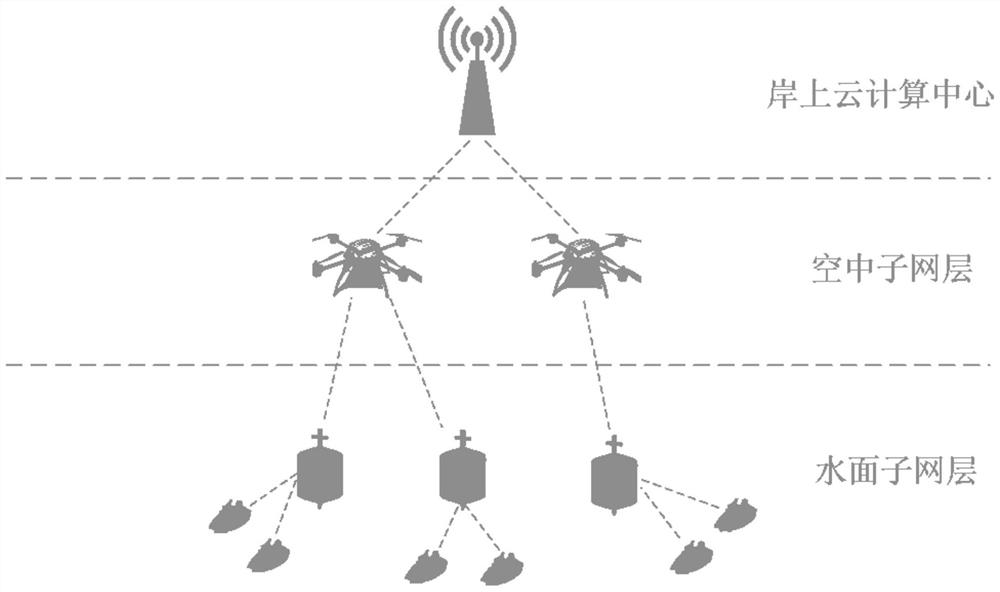
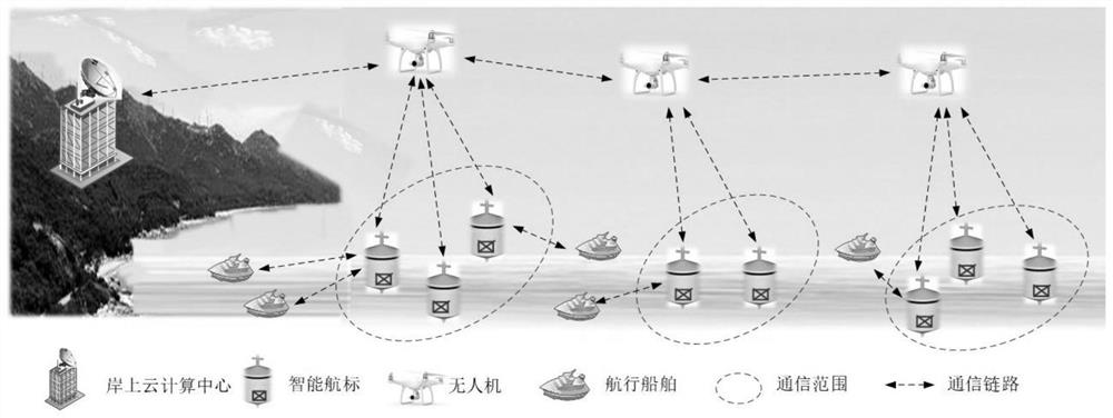
[0019] like figure 1 The shown is an offshore three-dimensional linkage networking and channel supervision system for the collaborative intelligent beacon of unmanned aerial vehicles, including: a surface sub-network layer, an aerial sub-network layer and an onshore cloud computing center.

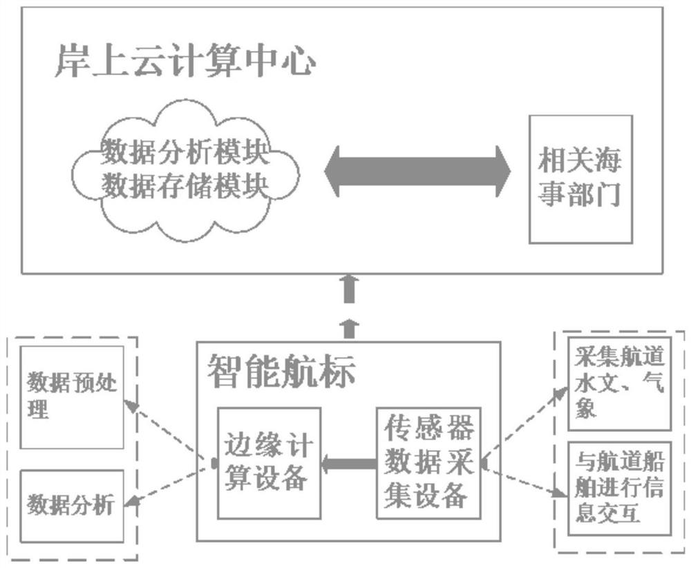
[0020] The smart beacons in the water sub-network layer are equipped with sensor devices and edge computing devices. The composition of intelligent navigation aids is as follows figure 2 shown. Among them, the sensor equipment is responsible for collecting hydrometeorological data such as channel water flow, water depth, wind and wind direction, and visibility, as well as ship navigation d...


PUM


Abstract

The invention discloses an offshore three-dimensional linkage networking and channel supervision system of unmanned aerial vehicle group collaborative intelligent navigation beacon, including a surface sub-network layer, an aerial sub-network layer and an onshore cloud computing center; Combining the high-altitude viewing angle and strong maneuverability of the UAV with the maritime advantages of the beacon to implement a seamless monitoring and communication system for the channel, it has higher efficiency and real-time performance; in addition, the beacon is embedded in the sensor equipment to realize the hydrological and meteorological information of the channel. In addition, the navigation mark embedded in the edge computing device can directly preprocess the collected information and transmit it to the marine navigation ships and UAVs through wireless communication. The edge computing equipment directly preprocesses the data collected by the navigation mark, reduces the bandwidth consumed by the data transmission at sea, and at the same time ensures that the sailing ship can obtain the relevant information of the channel in the shortest time, so as to ensure the safety of the ship's navigation.

Description

technical field [0001] The invention relates to a three-dimensional linkage networking and a channel supervision system for collaborative intelligent beacons of unmanned aerial vehicles, relates to the field of edge computing, network deployment optimization, data forwarding and storage and other related fields, and in particular relates to a collaborative path suitable for unmanned aerial vehicles. The planned three-dimensional linkage networking and channel supervision system based on intelligent navigation marks. Background technique [0002] At present, channel monitoring methods mainly rely on modern monitoring systems such as traditional VTS, CCTV, AIS, and VHF, and there are few studies on dynamic monitoring methods. However, with the rapid development of the shipping industry, the problems faced by maritime supervision are becoming more and more diverse, and the supervision tasks are becoming more and more onerous. In the prior art, the new type of beacon light is g...

Claims


Application Information

Patent Timeline
Patent Type & Authority Patents(China)
IPC IPC(8): G08G3/00
CPCG08G3/00
Inventor 林彬张雅静王莹孙璐
Owner DALIAN MARITIME UNIVERSITY
Why Eureka
Try Eureka