
Geological disaster landslide real-time monitoring and management system based on big data

A technology for real-time monitoring and geological disasters, applied in data processing applications, special data processing applications, measuring devices, etc., can solve the problems of inaccurate monitoring data, low reliability, and poor timeliness, so as to avoid inaccurate monitoring data and ensure The effect of life and property safety and accuracy improvement

Inactive Publication Date: 2020-12-08
张婉婷
View PDF0 Cites 8 Cited by
  • Summary
  • Abstract
  • Description
  • Claims
  • Application Information

AI Technical Summary

Problems solved by technology

[0003] At present, most of the landslide monitoring technologies in the prior art use manual inspection methods. In continuous rainfall or heavy rainfall weather, people are sent up the mountain to check whether there are signs of sliding, which has poor timeliness, low reliability, and large monitoring limitations. At the same time, the safety of the inspectors cannot be guaranteed; the existing landslide monitoring method is a manual prediction method, which has the problems of inaccurate, unscientific and insufficient information coverage, resulting in insufficient early warning results and landslides. It has the characteristics of sudden and strong, and it is impossible to achieve timely early warning effect, so that people do not respond well to time and measures when disasters come, causing casualties and property losses. In order to solve the above problems, a big data-based system is now designed Real-time Monitoring and Management System for Geological Hazards and Landslides

Method used


Image

  • Geological disaster landslide real-time monitoring and management system based on big data

Examples


Embodiment Construction

[0032] The following will clearly and completely describe the technical solutions in the embodiments of the present invention with reference to the accompanying drawings in the embodiments of the present invention. Obviously, the described embodiments are only some, not all, embodiments of the present invention. Based on the embodiments of the present invention, all other embodiments obtained by persons of ordinary skill in the art without creative efforts fall within the protection scope of the present invention.

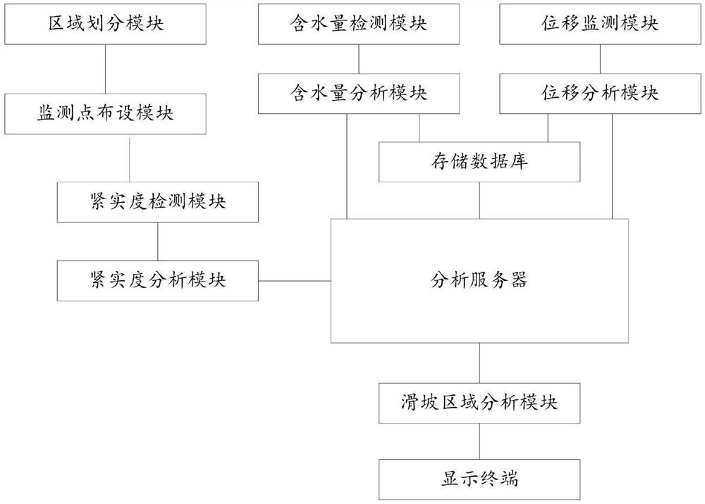
[0033] see figure 1 As shown, a real-time monitoring and management system for geological disaster landslides based on big data, including area division module, monitoring point layout module, compactness detection module, compactness analysis module, water content detection module, water content analysis module, displacement Monitoring module, displacement analysis module, analysis server, landslide area analysis module, display terminal and storage database;

[...


PUM


Abstract

The invention discloses a geological disaster landslide real-time monitoring and management system based on big data. The system comprises a region division module, a monitoring point arrangement module, a compactness detection module, a compactness analysis module, a water content detection module, a water content analysis module, a displacement monitoring module, a displacement analysis module,an analysis server, a landslide region analysis module, a display terminal and a storage database. According to the invention, a landslide region is divided through a region division module, the compactness of soil in each sub-region is detected, the soil type corresponding to the compactness of the soil in each sub-region is screened while the water content and space coordinates of the soil in each sub-region are detected, the stability influence coefficient of landslide in each sub-region is calculated, whether the landslide of each sub-region is in a safety stage is compared and analyzed, the sub-regions in a dangerous stage are classified according to different depths, and a dangerous comprehensive region is determined and displayed, so that the life and property safety of personnel isguaranteed.

Description

technical field [0001] The invention relates to the field of landslide disaster monitoring and management, and relates to a real-time monitoring and management system for geological disaster landslides based on big data. Background technique [0002] In recent years, there have been many landslide accidents in our country, causing a large number of human and economic losses. The country has paid more and more attention to the monitoring and management of landslides, and the investment in technical force and resources has also increased year by year. [0003] At present, most of the landslide monitoring technologies in the prior art use manual inspection methods. In continuous rainfall or heavy rainfall weather, people are sent up the mountain to check whether there are signs of sliding, which has poor timeliness, low reliability, and large monitoring limitations. At the same time, the safety of the inspectors cannot be guaranteed; the existing landslide monitoring method is ...

Claims


Application Information

Patent Timeline
Patent Type & Authority Applications(China)
IPC IPC(8): G06Q10/06G06F30/20G01D21/02
CPCG01D21/02G06Q10/0635G06F30/20
Inventor 张婉婷
Owner 张婉婷
Learn More