A three-dimensional terrain auxiliary surveying and mapping device for cities

A technology of three-dimensional terrain and surveying and mapping devices, applied in the field of surveying and mapping, can solve problems such as damage and danger of auxiliary devices and manhole covers, and achieve the effect of improving practicability and work efficiency

Active Publication Date: 2022-05-13
昆明麦普空间科技有限公司
View PDF7 Cites 0 Cited by
  • Summary
  • Abstract
  • Description
  • Claims
  • Application Information

AI Technical Summary

Problems solved by technology

[0003] The surveying and mapping of urban topographic maps mainly adopts flat-panel surveying and notation methods, and aerial photogrammetry can also be used. In the work of surveying and mapping urban three-dimensional topographic maps, it is necessary to carry out some underground surveying and mapping work. Or during the measurement method, it is usually necessary to lift the well cover first. The existing auxiliary devices generally use the continuous force acting on the well cover to lift the well cover. Because some well covers are soaked and rusted by rain for many years, this kind The continuous force acts on the manhole cover. Firstly, it will damage the auxiliary device and the manhole cover to a certain extent. Second, when the manhole cover is lifted, the manhole cover may fly up due to inertia, which is very dangerous. corresponding improvement

Method used


Image

  • A three-dimensional terrain auxiliary surveying and mapping device for cities
  • A three-dimensional terrain auxiliary surveying and mapping device for cities
  • A three-dimensional terrain auxiliary surveying and mapping device for cities

Examples


Embodiment 1

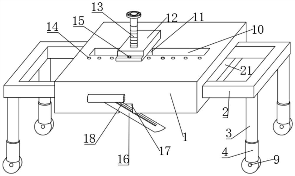
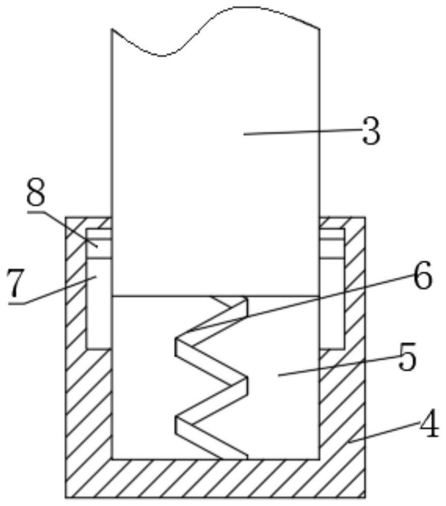
[0027] Reference Figure 1-4 , a kind of urban three-dimensional terrain auxiliary mapping device, including a workbench 1, the inner side of the table 1 symmetrically set with two support rods 2, the support rod 2 section is set to a U-shape, the support rod 2 bottom is bolted with two inner rods 3, the inner rod 3 bottom sleeve is equipped with an outer tube 4, the outer pipe 4 is opened with a first groove 5, the first groove 5 is bolted inside with the first spring 6, the first spring 6 is fixed at the top and the inner rod 3 bottom is welded, and the top of the table 1 is opened with a second chute 10. The second sliding groove 10 is connected with a second slider 11, the second slider 11 is welded with a mounting plate 12, the mounting plate 12 and the second slider 11 are connected with the same thread 13 through the thread 13, the first screw 13 is provided with a finite mechanism at the bottom, the table 1 is provided with a fixing mechanism, the table 1 is opened at the b...

Embodiment 2

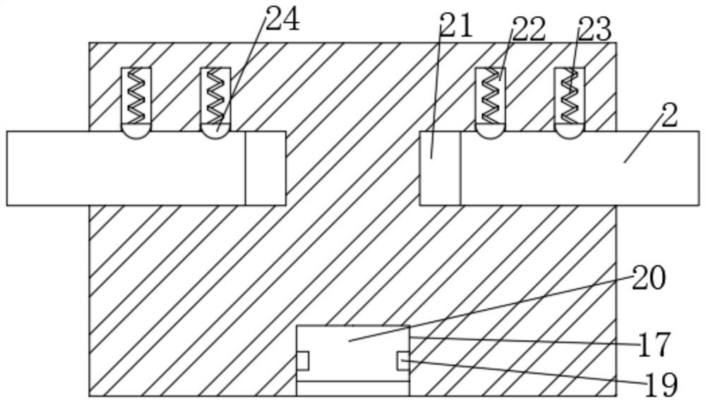
[0031] Reference Figure 1-5, a kind of urban three-dimensional terrain auxiliary mapping device, the first screw 13 bottom welded with mounting block 29, the limit mechanism is set inside the mounting block 29, the first screw 13 is opened with a third groove 26, the third groove 26 is provided with a second screw 27, the bottom of the second screw 27 and the bottom of the inner wall of the mounting block 29 are connected by hinge rotation, the first screw 13 is opened with a second groove 25, the second groove 25 and the third groove 26 are connected, and the second screw 27 is threaded with a moving block 28, The outer wall of the moving block 28 circumference is connected by hinge rotation to have multiple first rods 30, the first rod 30 is welded to the top with multiple non-slip bumps 32, the first rod 30 is connected by hinge rotation to the second rod 31, the second rod 31 bottom and the bottom of the inner wall of the mounting block 29 are connected by hinge rotation.

[...


PUM


Abstract

The present invention belongs to the technical field of surveying and mapping, especially a three-dimensional terrain auxiliary surveying and mapping device for cities. Aiming at the problem that the existing devices are relatively dangerous, the following scheme is proposed, including a workbench, and two support rods are arranged symmetrically on both sides of the workbench , the bottom of the support rod is fixed with two inner rods, the bottom of the inner rod is covered with an outer tube, the top of the workbench is provided with a second chute, the second chute is slidably connected with a second slider, and the top of the second slider The mounting plate is welded, the mounting plate and the second slider are threaded through the same first screw, the bottom of the front end of the workbench is provided with a notch, two fourth sliders are symmetrically fixed on both sides of the notch, and two fourth A crowbar is arranged between the slide blocks. In the present invention, the crowbar is adjusted to a suitable position for exerting force, and the crowbar is moved up and down intermittently. Under the action of the first spring, the limiting mechanism generates vibration forces of different frequencies on the well cover, so that the vibration force and the well cover resonate. Thereby prying the manhole cover loose.

Description

Technical field [0001] The present invention relates to the field of mapping technology, in particular to an urban three-dimensional terrain auxiliary mapping device. Background [0002] The planning, design, construction and operation management of urban construction includes urban control surveying, urban topographic map mapping, compilation and drawing of various thematic maps, construction lofting during the construction of municipal projects, and deformation observation of important buildings. All kinds of civil buildings, industrial and municipal engineering construction in the city are guided by urban planning, and the preparation of urban planning requires topographic maps of various scales. With the development of urban construction, features and landforms are constantly changing. In order for the content of the topographic map to be consistent with the situation on the ground, it is necessary to revise the topographic map in a timely manner. [0003] Surveying and mapp...

Claims


Application Information

Patent Timeline
Patent Type & Authority Patents(China)
IPC IPC(8): B66F19/00G01C15/00
CPCB66F19/005G01C15/00
Inventor 刘贺徐朔周爱家杨圣闯刘养波
Owner 昆明麦普空间科技有限公司
Why Eureka
Try Eureka