
Railway GIS map data processing method

A GIS map and data processing technology, applied in special data processing applications, geographic information databases, neural learning methods, etc., can solve problems such as errors and affect the normal operation of railways, achieve accurate correction results, reduce costs and work intensity, reduce The effect of positioning error

Active Publication Date: 2020-11-20
成都中轨轨道设备有限公司
View PDF5 Cites 0 Cited by
  • Summary
  • Abstract
  • Description
  • Claims
  • Application Information

AI Technical Summary

Problems solved by technology

[0004] However, when the positions of stations and equipment along the railway line change, they cannot be reflected in the GIS map. In the process of using the GIS map, when the geographical coordinates of each station and equipment cannot be updated in real time, errors occur and affect the railway normal operation of

Method used


Image

  • Railway GIS map data processing method

Examples


Embodiment Construction

[0018] The specific embodiments of the present invention are described below so that those skilled in the art can understand the present invention, but it should be clear that the present invention is not limited to the scope of the specific embodiments. For those of ordinary skill in the art, as long as various changes Within the spirit and scope of the present invention defined and determined by the appended claims, these changes are obvious, and all inventions and creations using the concept of the present invention are included in the protection list.

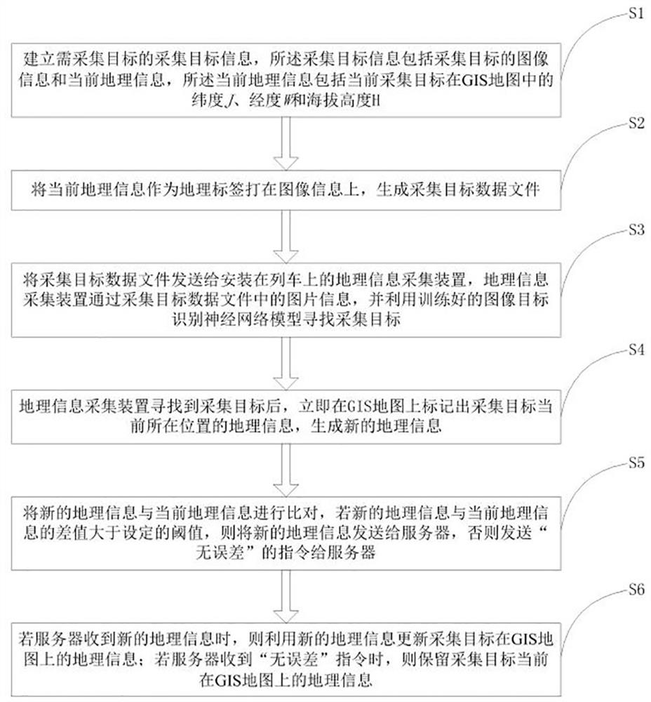
[0019] Such as figure 1 As shown, the railway GIS map data processing method provided by this program includes the following steps:

[0020] S1: Establish the collection target information of the target to be collected. The collection target information includes the image information of the collection target and the current geographic information. The current geographic information includes the latitude of the current colle...


PUM


Abstract

The invention discloses a railway GIS map data processing method which comprises the following steps: acquisition target information of a target to be acquired is established, and an acquisition target data file is generated; the trained image target recognition neural network model is utilized to search an acquisition target, the geographic information of the current position of the acquisition target is marked on a GIS map, new geographic information is generated, the new geographic information is compared with the current geographic information, and the geographic information is corrected.According to the scheme, the problem that an existing railway GIS map cannot quickly and accurately update geographic information of stations, equipment and the like along a railway is solved; the GISmap is ensured to be more reliable and accurate in the using process, positioning errors are reduced, the correction result is accurate, and the cost and the working intensity of manually collectinggeographic information on site are reduced.

Description

technical field [0001] The invention relates to the technical field of map data processing, in particular to a method for processing railway GIS map data. Background technique [0002] Geographic Information System (Geographic Information System or Geo-Information system, GIS) is sometimes called "geoscience information system", referred to as GIS map data. A technical system for collecting, storing, managing, computing, analyzing, displaying and describing geographically distributed data in space. [0003] At present, the use of GIS maps in the railway field can realize real-time update and monitoring of equipment coordinates on the map, such as: which line is the on-site personnel, equipment or train located (uplink or downlink), which line of the station The track; which mileage point is the on-site personnel, equipment or train located near; which feature point of the turnout is located by the on-site personnel, equipment or train (basic rail joint, switch before the sw...

Claims


Application Information

Patent Timeline
Patent Type & Authority Applications(China)
IPC IPC(8): G06F16/29G06N3/04G06N3/08G06K9/00G06K9/62
CPCG06F16/29G06N3/04G06N3/08G06V20/13G06F18/214
Inventor 廖峪唐泰可王威苏茂才
Owner 成都中轨轨道设备有限公司
Learn More