Method for identifying ship violation closing AIS behaviors by using high-resolution satellite images

A satellite image, high-resolution technology, applied in scene recognition, character and pattern recognition, image data processing, etc., can solve problems such as easy to be guarded against, and achieve the effect of improving the technical level

Pending Publication Date: 2020-11-10
TIANJIN RES INST FOR WATER TRANSPORT ENG M O T
View PDF0 Cites 0 Cited by
  • Summary
  • Abstract
  • Description
  • Claims
  • Application Information

AI Technical Summary

Problems solved by technology

The inspection method of the ship is random patrol by the sea patrol ship, observing the surrounding ships and the AIS information of the ship displayed on the electronic chart, which is very random and accidental; moreover, since the sea patrol ship itself turns on AIS, it is very easy to be guarded against

Method used


Image

  • Method for identifying ship violation closing AIS behaviors by using high-resolution satellite images
  • Method for identifying ship violation closing AIS behaviors by using high-resolution satellite images
  • Method for identifying ship violation closing AIS behaviors by using high-resolution satellite images

Examples


Embodiment Construction

[0028] The present invention will be further described below in conjunction with the accompanying drawings and specific embodiments, but the following embodiments in no way limit the present invention.

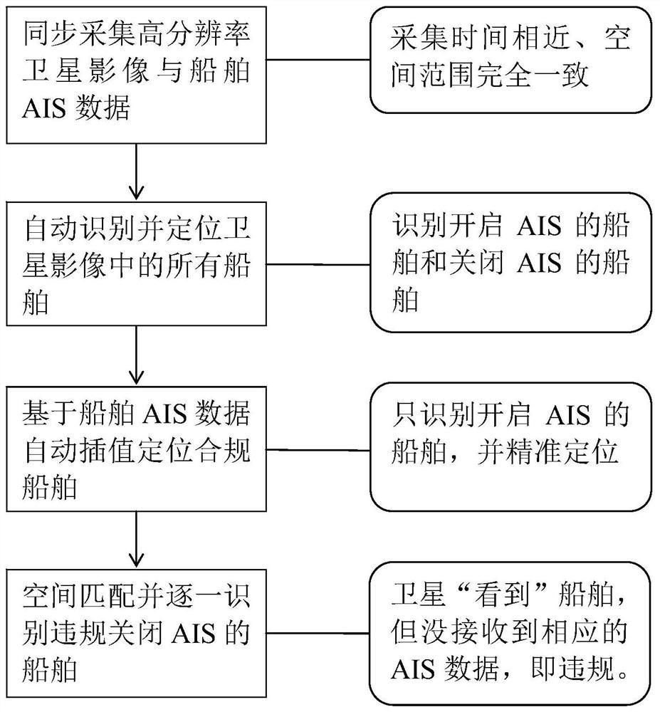
[0029] like figure 1 As shown, the specific implementation steps of the method for using high-resolution satellite imagery to identify the violation of the AIS behavior of ships are as follows:

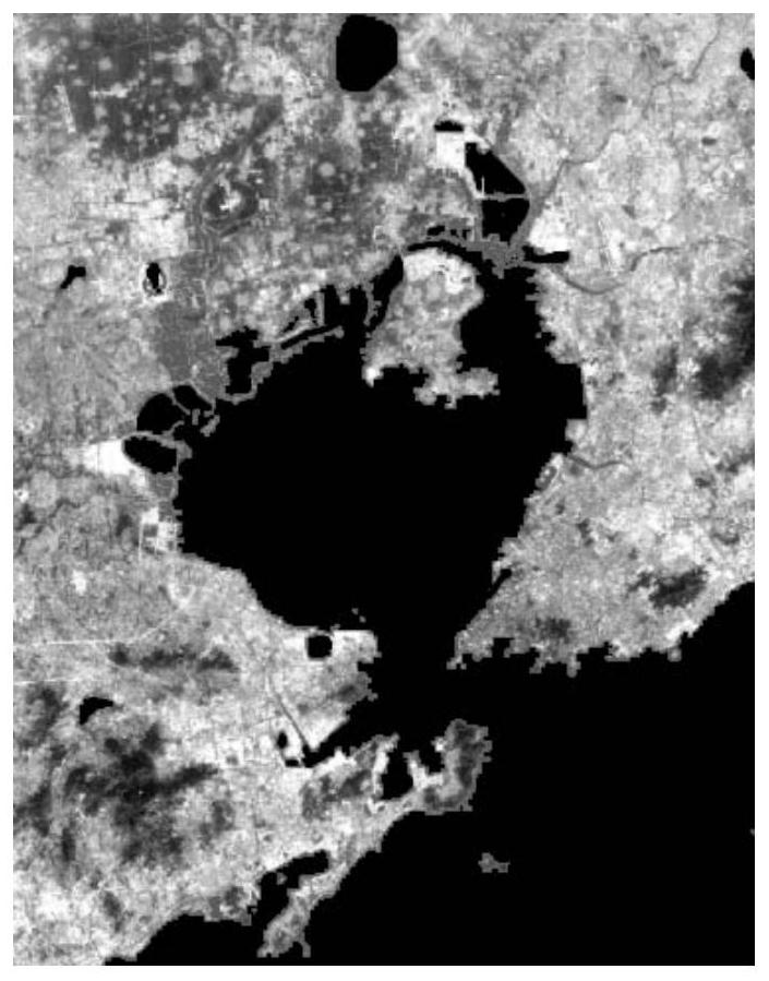
[0030] Step 1. Obtain satellite images of monitored waters and eliminate non-water areas:

[0031] Obtain a satellite image of a certain water area collected by a high-resolution satellite at time t, such as figure 2 shown; and then overlay it with the electronic map containing the water area to remove the land part in the satellite image and leave only the water area part;

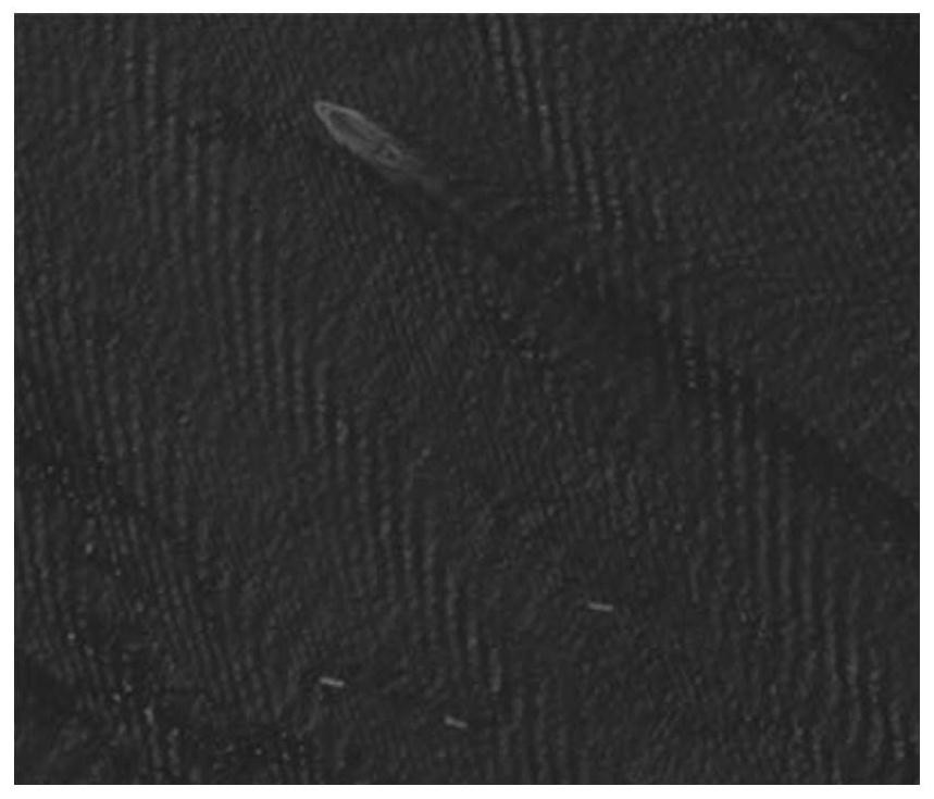
[0032] Step 2. Obtain the actual navigation situation of the ship according to the satellite image:

[0033] S201. Separate the satellite images into images of different bands, and then calculate the grayscal...


PUM


Abstract

The invention discloses a method for identifying ship illegal closing AIS behaviors by using high-resolution satellite images. The method sequentially comprises the following steps: 1) acquiring high-resolution satellite images and removing land parts; 2) converting the satellite image with the multi-band characteristics into a grey-scale map sensitive to a water body so as to highlight ships to acquire the geographic position of each ship according to the geographic information of the satellite image; 3) calling AIS data of all ships in the same water area within a time period from t1min to t+ 1min; (4) obtaining the position (t, xAIS, yAIS) of each ship which opens the AIS in compliance at the moment t; 5) matching the ship under the satellite image in the step 4) with the ship which opens the AIS in compliance, wherein the unmatched ship represents the ship which does not open the AIS in compliance; the illegal AIS closing behavior of the ship in a large-range area can be quickly mastered, the maritime law enforcement force can be guided to carry out targeted accurate inspection, and the technical level of maritime safety supervision is further improved.

Description

technical field [0001] The invention relates to the technical field of an inspection method for a ship's illegal shutdown of AIS, in particular to a method for identifying a ship's violation of AIS shutdown by using high-resolution satellite images. Background technique [0002] Ship AIS system is the abbreviation of Automatic Identification System, a system that broadcasts its own information to ships and shore stations in nearby waters through the VHF channel. The information content includes static information such as ship name and call sign and real-time GPS Positioning, speed and other dynamic information. In order to ensure the safety of water navigation and mutual knowledge of identity and location, ships must turn on the AIS system in accordance with regulations when sailing. However, some ships will turn off the AIS system to evade the supervision of maritime law enforcement forces when conducting illegal operations, such as fishing during closed fishing seasons, s...

Claims


Application Information

Patent Timeline
IPC IPC(8): G06K9/00G06K9/62G06T3/40
CPCG06T3/4007G06V20/13G06V10/751
Inventor 胡健波赵宏鑫彭士涛
Owner TIANJIN RES INST FOR WATER TRANSPORT ENG M O T
Why Eureka
Try Eureka