Method for quickly integrating and displaying three-dimensional geographic information system
A geographic information system, three-dimensional technology, applied in the field of rapid integration and display of three-dimensional geographic information systems
- Summary
- Abstract
- Description
- Claims
- Application Information
AI Technical Summary
Problems solved by technology
Method used
Image

Examples
Embodiment 1
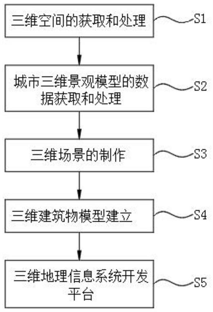
[0029] The present invention also discloses a method for rapid integration and presentation of a three-dimensional geographic information system, which includes the following steps:
[0030] S1. Acquisition and processing of 3D space data, first collect surface DEM data, provide basic data for the establishment of ground models, and provide the geographic basis for urban 3D landscapes, and then collect ground image data, through remote sensing satellite data or aerial photography Data to obtain surface physical information, and then collect ground object information, mainly including rivers, road vector data, buildings, overpasses, and CAD modeling data, and finally collect relevant attribute information and attribute elements in 3D ground objects;
[0031] S2. The data acquisition and processing of the urban 3D landscape model. The ground surface model is established by superimposing the digital elevation model and the orthophoto image, and the building 3D model is established...
Embodiment 2
[0047] The present invention also discloses a method for rapid integration and presentation of a three-dimensional geographic information system, which includes the following steps:
[0048] S1. Acquisition and processing of 3D space data, first collect surface DEM data, provide basic data for the establishment of ground models, and provide the geographic basis for urban 3D landscapes, and then collect ground image data, through remote sensing satellite data or aerial photography Data to obtain surface physical information, and then collect surface object information, mainly including rivers, road vector data, buildings, overpasses, and CAD modeling data and data about vegetation information, and finally collect relevant attribute information in 3D objects, and attribute elements;
[0049] S2. The data acquisition and processing of the three-dimensional urban landscape model. The surface model is established by superimposing the digital elevation model and the orthophoto image...
Embodiment 3
[0065] The present invention also discloses a method for rapid integration and presentation of a three-dimensional geographic information system, which includes the following steps:
[0066] S1. Acquisition and processing of 3D space data, first collect surface DEM data, provide basic data for the establishment of ground models, and provide the geographic basis for urban 3D landscapes, secondly collect ground image data, and obtain surface textures and textures through remote sensing satellite data information, and then collect rivers, road vector data, buildings, overpasses, and CAD modeling data, as well as data about vegetation information, as well as tree physical and physical image data, and finally collect relevant attribute information in 3D ground objects ;
[0067] S2. The data acquisition and processing of the urban 3D landscape model. The surface model is established by superimposing the digital elevation model, and the building 3D model is established by superimpos...
PUM
 Abstract
Description
Claims
Application Information
 - R&D
- Intellectual Property
- Life Sciences
- Materials
- Tech Scout
- Unparalleled Data Quality
- Higher Quality Content
- 60% Fewer Hallucinations
Browse by: Latest US Patents, China's latest patents, Technical Efficacy Thesaurus, Application Domain, Technology Topic, Popular Technical Reports.
© 2025 PatSnap. All rights reserved.Legal|Privacy policy|Modern Slavery Act Transparency Statement|Sitemap|About US| Contact US: help@patsnap.com