Reconstruction or extension road earth volume calculation method based on oblique photography technology
A technology of oblique photography and calculation method, which is applied in the direction of photogrammetry/video metrology, calculation, measuring device, etc., and can solve the problems of disrepair, urgent repair and maintenance of roads, etc.
- Summary
- Abstract
- Description
- Claims
- Application Information
AI Technical Summary
Problems solved by technology
Method used
Image
Examples
Embodiment Construction
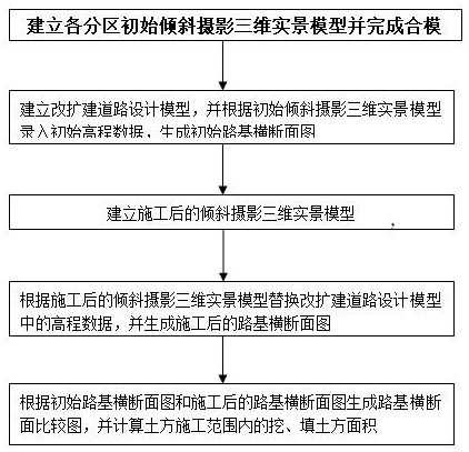
[0028] Example figure 1 As shown, the present invention is based on oblique photographic technology reconstruction or expansion road earthwork calculation method comprises the following steps:
[0029] Step 1. Collect and sort out geographical location data and construction drawing files of roads for reconstruction and expansion;
[0030] Step 2. Determine the aerial photography route and parameters of the UAV according to the site survey and electronic map, use the UAV to take pictures according to the aerial photography route and parameters, generate preliminary oblique photography data for each partition, and use the aerial photography pos data to remove unnecessary and redundant data. Oblique photographic three-dimensional real-scene model of each partition forming the shooting area;
[0031] Among them, unnecessary and redundant data refers to oblique photographic data beyond the specified scope of the project, abnormal oblique photographic data, such as data in oblique ...
PUM
 Abstract
Description
Claims
Application Information
 - R&D Engineer
- R&D Manager
- IP Professional
- Industry Leading Data Capabilities
- Powerful AI technology
- Patent DNA Extraction
Browse by: Latest US Patents, China's latest patents, Technical Efficacy Thesaurus, Application Domain, Technology Topic, Popular Technical Reports.
© 2024 PatSnap. All rights reserved.Legal|Privacy policy|Modern Slavery Act Transparency Statement|Sitemap|About US| Contact US: help@patsnap.com


