
Refined grid evaluation method for supporting territorial space planning double evaluation

A technology of spatial planning and evaluation methods, applied in the directions of instruments, data processing applications, file/folder operations, etc., which can solve the problems that the spatial scale cannot be completely unified and disadvantageous, etc.

Pending Publication Date: 2020-10-20
WUHAN UNIV
View PDF1 Cites 4 Cited by
  • Summary
  • Abstract
  • Description
  • Claims
  • Application Information

AI Technical Summary

Problems solved by technology

The spatial scales of the two evaluations cannot be completely unified, which is not conducive to the fine delineation of "three districts and three lines" in spatial planning

Method used


Image

  • Refined grid evaluation method for supporting territorial space planning double evaluation
  • Refined grid evaluation method for supporting territorial space planning double evaluation
  • Refined grid evaluation method for supporting territorial space planning double evaluation

Examples


Embodiment Construction

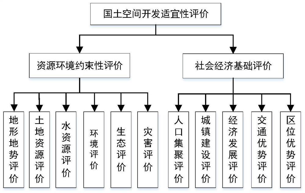
[0120] In order to make the object, technical solution and advantages of the present invention clearer, the present invention will be further described in detail below in conjunction with the accompanying drawings and embodiments. It should be understood that the specific embodiments described here are only used to explain the present invention, not to limit the present invention.

[0121] The refined grid evaluation method supporting the "double evaluation" of national land space planning in the embodiment of the present invention, such as Figure 12 shown, including the following steps:

[0122] Step 1. Generation of refined grid and parallel computing scheme

[0123] Delineate the evaluation scope based on the research area, determine the spatial scale of the grid coordinate points according to the refined requirements of the evaluation, determine the maximum parallel calculation amount according to the available computer hardware conditions, and design the parallel calcul...


PUM


Abstract

The invention discloses a refined grid evaluation method for supporting territorial space planning double evaluation. The refined grid evaluation method comprises the following steps: preparing coordinate scatter data, dividing a parallel computing scheme according to available computer hardware resources, preparing a block control file, and generating a refined block grid coordinate point file, ablock information file and a block control file; converting the standard and processing file into a basic (grade 3) index through methods of space allocation, inverse distance interpolation, four-point interpolation, nearest neighbor interpolation and the like; according to the calculation formula of each evaluation index, modifying the calculation formula in the parallel calculation process to calculate the index; and according to a calculation result, combining the partitioning results, and converting the partitioning results into a visual result for checking and inspection. Through the above steps, refined grid evaluation supporting territorial space planning 'double evaluation' can be realized.

Description

technical field [0001] The invention belongs to the technical field of space planning and urban development management, and specifically relates to a refined grid evaluation method supporting "double evaluation" of land space planning. Background technique [0002] Documents such as the "Provincial Spatial Planning Pilot Program" and "Guidelines for the Evaluation of Resource and Environmental Carrying Capacity and the Suitability of Land Space Development (Trial)" require that in the planning of national land space, "double evaluation" should be carried out, that is, the carrying capacity of resources and the environment and land space Development Suitability Evaluation. Combined with the current surface zoning and land ownership, analyze and identify unit plots that require ecological protection, are conducive to agricultural production, and are suitable for urban development, divide the appropriate grades and determine the scale reasonably, laying the foundation for the d...

Claims


Application Information

Patent Timeline
Patent Type & Authority Applications(China)
IPC IPC(8): G06Q10/04G06Q50/26G06F16/16
CPCG06Q10/04G06Q50/26G06F16/16Y04S10/50
Inventor 张万顺张潇彭虹
Owner WUHAN UNIV
Learn More