Urban river flood three-dimensional inundation analysis method based on oblique photography

A technology of oblique photography and analysis method, which is applied in image analysis, photogrammetry/video measurement, water resources assessment, etc. It can solve the problems that DOM data cannot collect the side texture of buildings, and cannot express high-precision inundation conditions, etc., to achieve Effect of Accuracy Improvement

Pending Publication Date: 2020-10-16
GUIZHOU SURVEY & DESIGN RES INST FOR WATER RESOURCES & HYDROPOWER
View PDF2 Cites 4 Cited by
  • Summary
  • Abstract
  • Description
  • Claims
  • Application Information

AI Technical Summary

Problems solved by technology

[0006] Traditional flood 3D submersion analysis often uses DEM superimposed on DOM for simulation. Due to the limitations of DOM data itself (the side texture of buildings cannot be collected), the DOM after DEM stretchi...

Method used


Image

  • Urban river flood three-dimensional inundation analysis method based on oblique photography

Examples


Embodiment Construction

[0023] The following will clearly and completely describe the technical solutions in the embodiments of the present invention with reference to the accompanying drawings in the embodiments of the present invention. Obviously, the described embodiments are only some, not all, embodiments of the present invention. Based on the embodiments of the present invention, all other embodiments obtained by persons of ordinary skill in the art without making creative efforts belong to the protection scope of the present invention.

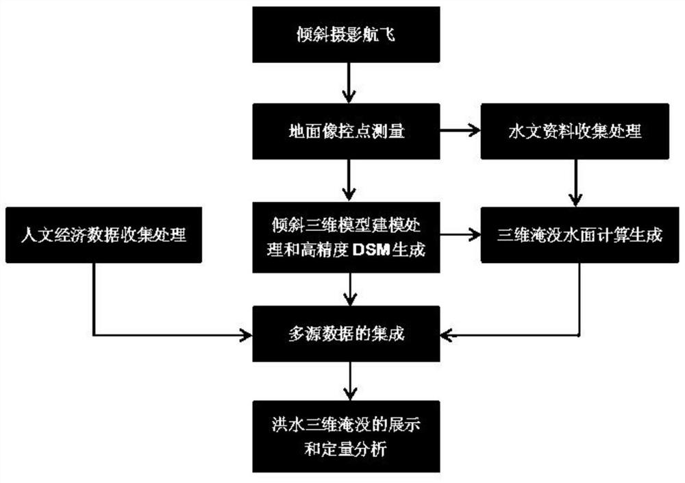
[0024] Such as figure 1 As shown, this embodiment specifically includes the following steps:

[0025] Step 1. Oblique photography aerial flight: Use multi-rotor drones to collect images from five different directions, including down-view and four side-views, to obtain high-resolution texture information and wireless HMI comes with high-precision POS data. Control the drone flight height and flight overlap to ensure that the average resolution of the original...


PUM


Abstract

The invention discloses an urban river flood three-dimensional inundation analysis method based on oblique photography. The method comprises the steps of oblique photography flight, ground image control point measurement, hydrological data and humanistic economic data collection and processing, oblique three-dimensional model and high-precision DSM data generation, three-dimensional submerged water surface calculation generation, multi-source data integration and three-dimensional submerged effect display, quantitative analysis of submerged disaster conditions and the like. By using the method, the simulation precision of urban river flood inundation can be greatly improved, a decision maker can conveniently, quickly and accurately formulate a flood fighting and disaster relief strategy, the flood fighting and disaster relief efficiency is improved, the time is saved, and further loss is reduced.

Description

technical field [0001] The invention belongs to the field of hydrological professional flood submersion analysis, in particular to a method for accurate three-dimensional submergence analysis of urban river channel flood by using the new technology of surveying and mapping professional oblique photography. Background technique [0002] River flood refers to the rapid rise of water level and the rapid increase of water flow rate in rivers. It is a kind of natural disaster, which occurs frequently and causes serious damage. my country has a vast territory, and more than three-quarters of the country's land area suffers from different degrees and types of flood disasters. Every year, our country needs to organize a large amount of manpower and material resources for disaster relief, which consumes countless financial resources and energy. With the continuous development and progress of the social economy, in order to reduce the loss of life and property caused by floods, it is...

Claims


Application Information

Patent Timeline
IPC IPC(8): G06T17/05G06T7/33G01C11/00
CPCG01C11/00G06T17/05G06T7/33Y02A90/30
Inventor 徐子扬杨文锋罗天文吴恒友徐锐何正林
Owner GUIZHOU SURVEY & DESIGN RES INST FOR WATER RESOURCES & HYDROPOWER
Why Eureka
Try Eureka