Unmanned ship laser radar point cloud data correction method based on attitude sensor and GNSS

An attitude sensor, point cloud data technology, applied in the field of unmanned ship lidar point cloud data correction based on attitude sensor and GNSS, can solve information errors such as hull roll and trim, lidar ranging, rotation angle, etc. Affect the target recognition accuracy and other issues, to achieve the effect of improving the accuracy and improving the scanning resolution

Pending Publication Date: 2020-09-25
SHANGHAI ADVANCED AVIONICS
View PDF4 Cites 12 Cited by
  • Summary
  • Abstract
  • Description
  • Claims
  • Application Information

AI Technical Summary

Problems solved by technology

[0004] In complex environments, especially in offshore application scenarios, water currents, waves, etc. will cause roll and pitch of the hull, which will cause errors in the original lidar ranging, rotation angle and other information, which will seriously affect the accuracy of target recognition. Accuracy
Especially in harsh sea conditions, the information reliability of lidar to identify obstacles and targets will be greatly reduced

Method used


Image

  • Unmanned ship laser radar point cloud data correction method based on attitude sensor and GNSS
  • Unmanned ship laser radar point cloud data correction method based on attitude sensor and GNSS
  • Unmanned ship laser radar point cloud data correction method based on attitude sensor and GNSS

Examples


Embodiment Construction

[0036] The present invention will be further described below in conjunction with the accompanying drawings and embodiments.

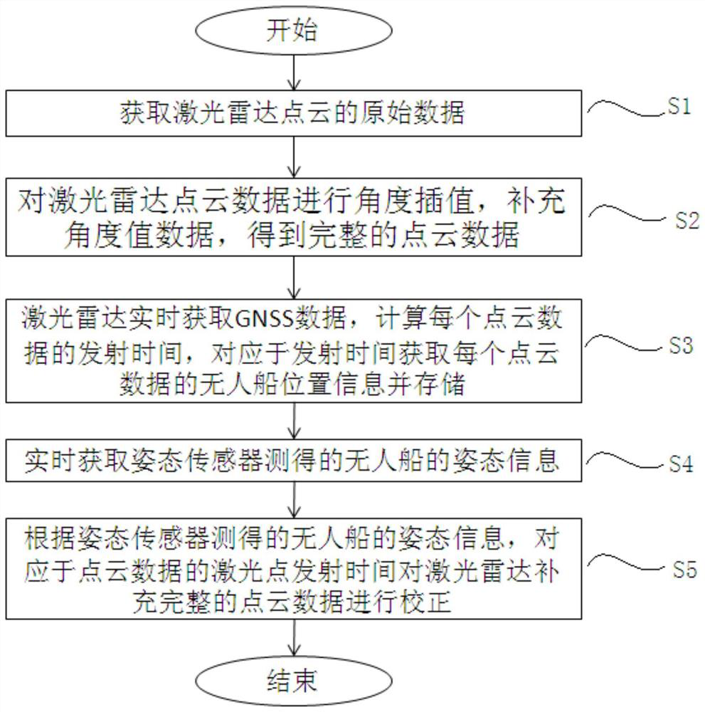
[0037] figure 1 It is a flow chart of an unmanned ship lidar point cloud data correction method based on an attitude sensor and GNSS in an embodiment of the present invention.

[0038] See figure 1 , the method for correcting unmanned ship lidar point cloud data based on attitude sensor and GNSS in the embodiment of the present invention comprises the following steps:

[0039] S1: Obtain the raw data of the lidar point cloud;

[0040] S2: Perform angle interpolation on the lidar point cloud data, supplement the angle value data, and obtain complete point cloud data;

[0041] S3: The laser radar acquires GNSS data in real time, calculates the laser emission time of each point cloud data, and obtains and stores the unmanned ship position information of each point cloud data corresponding to the emission time;

[0042]S4: Obtain the attitude informatio...


PUM


Abstract

The invention discloses an unmanned ship laser radar point cloud data correction method based on an attitude sensor and GNSS. The method comprises the following steps: S1, acquiring original data of laser radar point cloud; S2, performing angle interpolation on the laser radar point cloud data; S3, enabling the laser radar to obtain GNSS data in real time, calculating the transmitting time of eachpoint cloud data, and acquiring unmanned ship position information of each point cloud data; S4, acquiring attitude information, measured by an attitude sensor, of the unmanned ship; S5, according tothe attitude information of the unmanned ship measured by the attitude sensor, correcting the laser radar supplementary complete point cloud data. According to the invention, angle interpolation processing is carried out on the laser radar to improve the scanning resolution; a GNSS is accessed, a timestamp is added to each laser of the laser radar, and position information of each point cloud data is recorded; the attitude sensor corrects the laser radar point cloud data in real time, and reduces the error of laser radar target recognition and tracking.

Description

technical field [0001] The invention relates to a laser radar point cloud data correction method, in particular to an unmanned ship laser radar point cloud data correction method based on an attitude sensor and GNSS. Background technique [0002] Unmanned Surface Vessel (USV) has the characteristics of high automation and intelligence. It is an important development direction for future ship development and water transportation. It has bright application prospects in military, transportation, surveying and other fields. [0003] Lidar has the advantages of high ranging accuracy and good real-time performance, and compared with cameras, it is less affected by the rain and fog environment. Lidar is suitable for short-range environment perception and can meet the needs of unmanned ships in complex environments. Especially in the autonomous navigation of inland rivers and offshore complex environments, there is a need for rapid and accurate perception of the surrounding navigati...

Claims


Application Information

Patent Timeline
IPC IPC(8): G01S17/42G01S7/497G01S19/42
CPCG01S17/42G01S7/497G01S19/421Y02A90/10
Inventor 王新雅徐燕王南南袁敏倪侃俊钱伟张国兴
Owner SHANGHAI ADVANCED AVIONICS
Why Eureka
Try Eureka