Method for extracting ground object spatial distribution positions based on multi-source remote sensing data

A technology of spatial distribution and remote sensing data, applied in the direction of instruments, character and pattern recognition, scene recognition, etc., can solve the problems of complex vegetation environment and low precision, and achieve good separation, high precision and better classification effect

Pending Publication Date: 2020-07-24
贵阳欧比特宇航科技有限公司
View PDF7 Cites 1 Cited by
  • Summary
  • Abstract
  • Description
  • Claims
  • Application Information

AI Technical Summary

Problems solved by technology

[0002] When extracting the spatial distribution of tea planting based on a single optical satellite image data source, due to the complex surrounding vegetation environment, the accuracy of extraction for crops is low

Method used


Image

  • Method for extracting ground object spatial distribution positions based on multi-source remote sensing data
  • Method for extracting ground object spatial distribution positions based on multi-source remote sensing data
  • Method for extracting ground object spatial distribution positions based on multi-source remote sensing data

Examples


Embodiment Construction

[0038] The present invention will be further explained below in conjunction with the accompanying drawings and specific embodiments.

[0039] A method for extracting the spatial distribution position of ground objects based on multi-source remote sensing data, specifically described as follows:

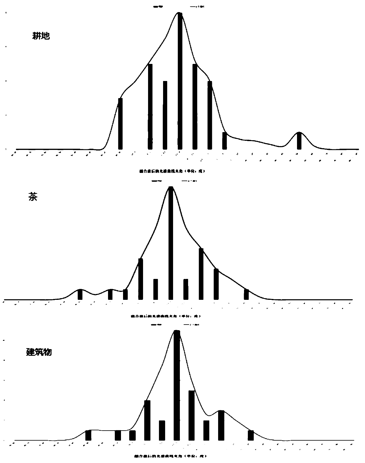
[0040] The present invention is based on the 10-meter resolution hyperspectral image of Orbit "Zhuhai No. "The rich spectral information of the 10-meter-resolution hyperspectral image and the texture information of the 0.8-meter-resolution high-resolution image of GF2 were fused. After data fusion, it was found that the included angle of the spectral information of the same ground object in the image had a slight change of less than 0.02 degrees. After comparing with the original high-resolution image, no problems such as geometric distortion, geographic location offset, and coordinate system error were found. And in the follow-up experiment, it was found that the fusion data obtaine...


PUM


Abstract

The invention discloses a method for extracting ground object spatial distribution positions based on multi-source remote sensing data. The method comprises the following steps: utilizing a hyperspectral image with Orbita "Zhuhai No. 1" 10-meter resolution and a high-resolution image with GF2 0.8-meter resolution; a multi-source remote sensing data fusion technology is adopted to discover that anincluded angle between spectral information of the same ground object in an image is slightly changed by less than 0.05 degree, and the problems of geometric distortion, geographic position offset, coordinate system error reporting and the like are not discovered after the image is compared with an original high-resolution image. The multi-source remote sensing method is adopted to extract the spatial distribution positions of the tea, and experiments find that the multi-source remote sensing method generates a more ideal effect on the extraction of the spatial positions of the tea.

Description

technical field [0001] The invention belongs to the field of remote sensing image information extraction, and in particular relates to a method for extracting spatial distribution positions of ground objects based on multi-source remote sensing. Background technique [0002] When extracting the spatial distribution of tea planting based on a single optical satellite image data source, the accuracy of extraction for crops is low due to the complex surrounding vegetation environment. Contents of the invention [0003] Purpose of the invention: The present invention provides a method for extracting the spatial distribution position of ground objects based on multi-source remote sensing with high extraction accuracy. [0004] A method for extracting the spatial distribution position of ground objects based on multi-source remote sensing data, comprising the following steps: when applying the Gram-Schmidt method to hyperspectral and high-resolution image fusion processing, an i...

Claims


Application Information

Patent Timeline
IPC IPC(8): G06K9/00G06K9/62
CPCG06V20/194G06V20/13G06F18/2411G06F18/253Y02A40/10
Inventor 陈章林唐浩杨刚朱安超陈添陈勇陆莎莎赵宗鸿樊鑫黄熙贤刘凯旋曹吉曹云成王雄杨波
Owner 贵阳欧比特宇航科技有限公司
Why Eureka
Try Eureka