
Fluorite mine recognition method and system based on remote sensing technology

A technology of remote sensing technology and identification method, applied in image detector method and image signal processing, image data processing, instrument and other directions, can solve problems such as failure to achieve survey results, large terrain fluctuations, poor traffic conditions, etc. Effects of Carbonate Ion Characterization

Active Publication Date: 2020-06-16
XIAN CENT OF GEOLOGICAL SURVEY CGS
View PDF11 Cites 0 Cited by
  • Summary
  • Abstract
  • Description
  • Claims
  • Application Information

AI Technical Summary

Problems solved by technology

[0003] At present, the geological and mineral exploration and investigation work is gradually extending to the central and western alpine deep cutting areas and remote areas with poor natural traffic conditions. These areas have harsh natural conditions, large terrain fluctuations, strong cutting, and extremely poor traffic conditions, which seriously affect the geological survey work. The development of the investigation resulted in a large amount of manpower and material resources being spent, but the corresponding investigation effect could not be achieved.

Method used


Image

  • Fluorite mine recognition method and system based on remote sensing technology
  • Fluorite mine recognition method and system based on remote sensing technology

Examples


Embodiment Construction

[0036] The present invention will be described in further detail below in conjunction with the accompanying drawings.

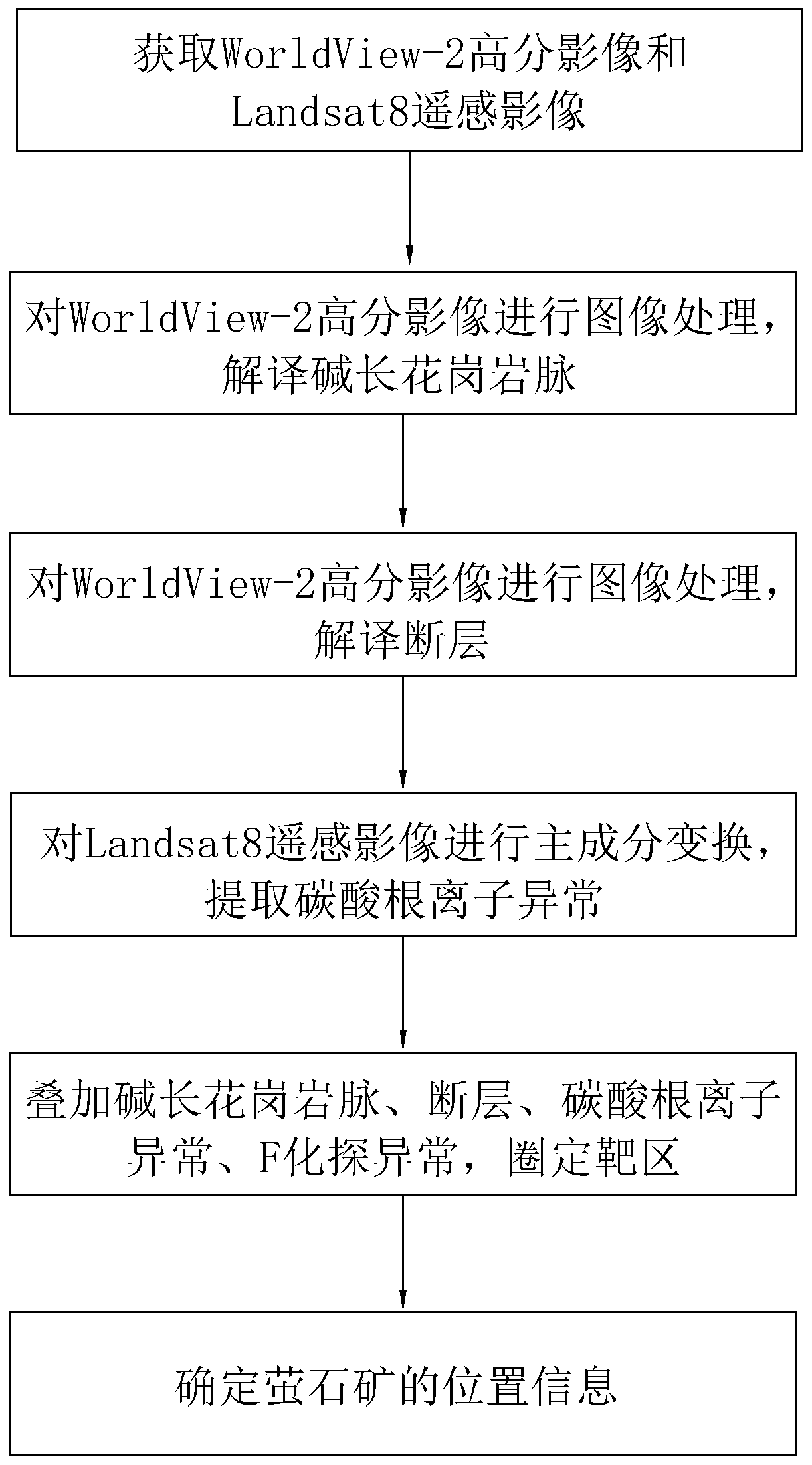
[0037] A method for identifying fluorite mines based on remote sensing technology, referring to figure 1 , including the following steps: S1, obtaining the WorldView-2 high-resolution image and Landsat8 remote sensing image of the area to be identified; S2, performing image processing on the WorldView-2 high-resolution image, and interpreting the distribution area of ​​the alkali-feldspar granite dikes and faults; S3, Perform principal component transformation on Landsat8 remote sensing images to extract carbonate ion anomalies; S4, collect F geochemical anomalies in the area to be identified through geological data, and analyze the interpreted alkali-feldspar granite veins, faults, carbonate ion anomalies, and F geochemical anomalies. The abnormality is superimposed, and the prospecting target area is comprehensively delineated according to the geological fa...


PUM

PropertyMeasurementUnit
melting pointaaaaaaaaaa
Mohs hardnessaaaaaaaaaa

Abstract

The invention relates to a fluorite mine recognition method based on a remote sensing technology. The fluorite mine recognition method comprises the following steps: S1, acquiring a WorldView-2 high-resolution image and a Landsat8 remote sensing image of a to-be-identified region; s2, performing image processing on the WorldView-2 high-resolution image, and interpreting a distribution area of an alkali long granite vein and a fault; s3, principal component transformation is carried out on the Landsat8 remote sensing image, and carbonate ion anomaly is extracted; s4, collecting F-probe anomalies of a to-be-identified area through geological data, superposing the interpreted alkali long granite vein, fault, carbonate ion anomalies and F-probe anomalies, and comprehensively delineating an oreprospecting target area according to geological factors which comprises fault properties and marble distribution in a stratum; and S5, determining the position information of the fluorite mine according to the target area. Therefore, the position information of the fluorite mine can be efficiently, quickly and accurately determined in a short time.

Description

technical field [0001] The invention relates to the field of mineral resource identification of remote sensing technology, in particular to a method and system for identifying fluorite mines based on remote sensing technology. Background technique [0002] Fluorite, also known as fluorspar, is a common mineral in nature. It can coexist with many other minerals. It is produced in many places in the world. It is an equiaxed crystal system. The main component is calcium fluoride (CaF 2 ). Crystallized as octahedron and cube. The crystal is glass luster, bright and changeable, brittle, with a Mohs hardness of 4 and a melting point of 1360°C. It has the property of complete cleavage. This mineral comes from volcanic magma. During the cooling process of the magma, the gas-water solution separated by the magma contains fluorine. When the solution rises along the cracks, the fluoride ions in the gas-water solution combine with the calcium ions in the surrounding rocks to form fluo...

Claims


Application Information

Patent Timeline
Patent Type & Authority Applications(China)
IPC IPC(8): G06T7/00G06T7/136G01N21/17
CPCG01N21/17G01N2021/1765G01N2021/1797G06T7/0004G06T2207/10032G06T7/136
Inventor 高永宝金谋顺赵辛敏滕家欣燕洲泉
Owner XIAN CENT OF GEOLOGICAL SURVEY CGS
Learn More