
Pipeline survey system

A survey system and pipeline technology, applied in the field of surveying and mapping, can solve problems such as inability to satisfy decision-making, management departments and construction units, low efficiency, and manual labor for underground pipelines, and achieve the effects of flexible use, convenient operation, and efficient management.

Active Publication Date: 2020-05-15
厦门市博业众成测绘有限公司
View PDF4 Cites 1 Cited by
  • Summary
  • Abstract
  • Description
  • Claims
  • Application Information

AI Technical Summary

Problems solved by technology

[0004] The existing technical solutions mentioned above have the following defects: underground pipelines are managed manually, and the data of pipeline surveys are mainly recorded and stored in the form of physical objects, which is inefficient and cannot meet the requirements of The needs of decision-making, management departments and construction units

Method used


Image

  • Pipeline survey system
  • Pipeline survey system

Examples


Embodiment Construction

[0037] The present invention will be described in further detail below in conjunction with the accompanying drawings.

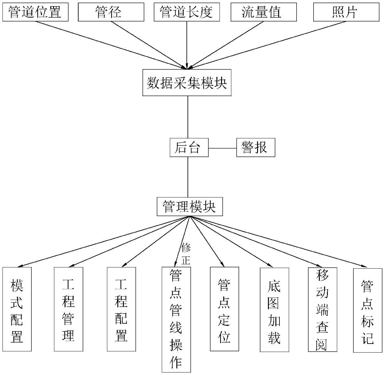
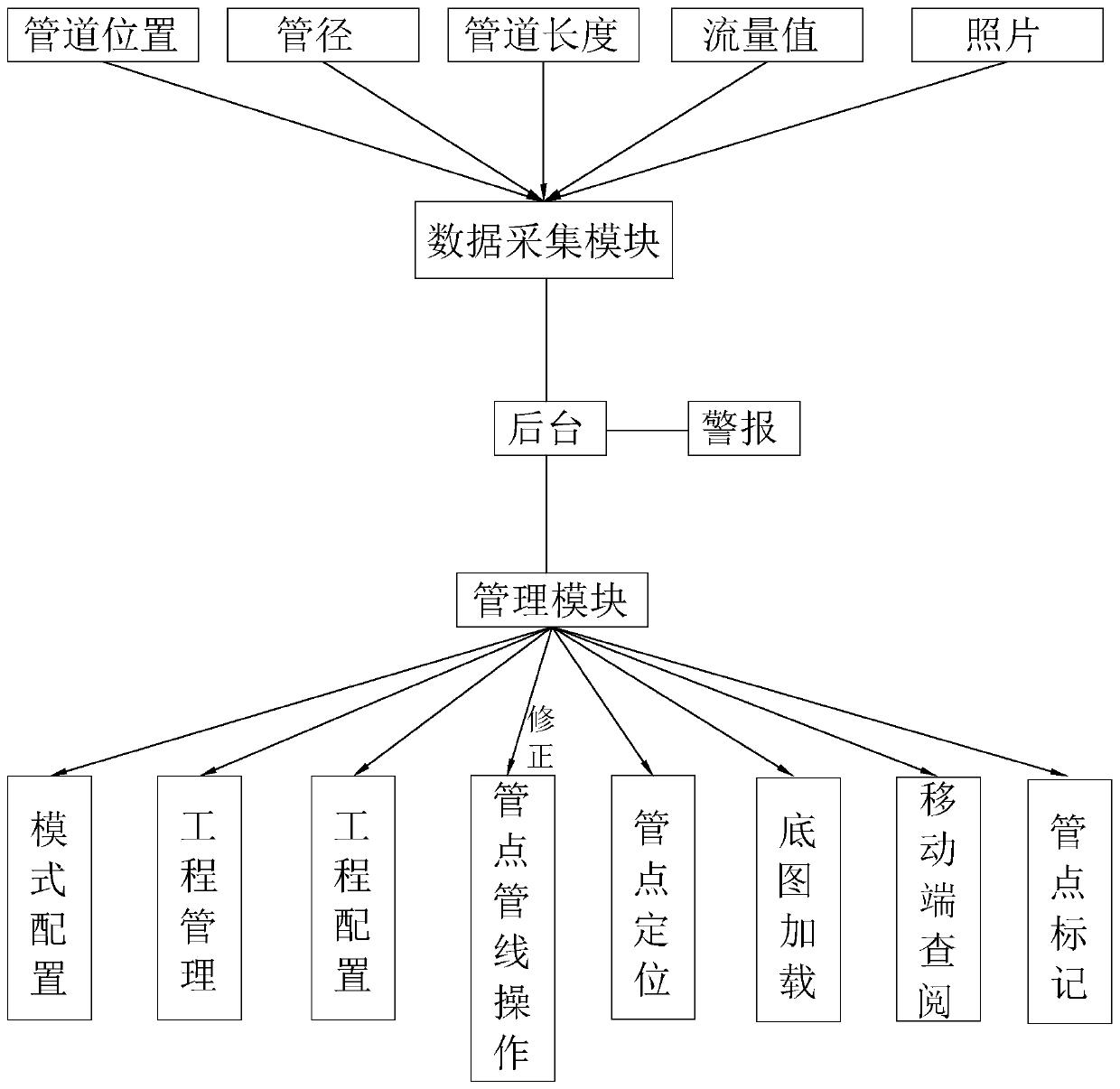
[0038] refer to figure 1 , is the pipeline survey system disclosed in the present invention, including a data collection module and a background for collecting information, and the information collected by the data collection module includes pipeline position, pipe diameter, pipeline length, flow value and photos flowing through the pipeline at a certain moment, Measure the position, diameter and length of the pipeline by laying out photoelectric distance measuring wires or GPS technology and leveling with the help of a total station, and take pictures of the internal conditions of the pipeline with the help of a dedicated closed-circuit television system. The diameter of the pipeline can be used to obtain The cross-sectional area of ​​the pipe.

[0039] Pipelines are divided and numbered according to the pipeline and several pipe points on the pipeline, and...


PUM


Abstract

The invention relates to the technical field of surveying and mapping, and aims to provide a pipeline surveying system, which comprises a data acquisition module, a background and a management module;the management module comprises mode configuration, engineering management, engineering configuration and pipe point pipeline operation; the mode configuration is used for configuring parameter information according to specification standards of different local areas; the project management is used for newly establishing or deleting projects; the engineering configuration is used for configuringa local standard of a project, and inputting and storing attribute information of surveyed pipe points in a background in sequence; the pipe point pipeline operation is used for drawing a pipeline anda pipe point, and the pipeline and the pipe point generate a two-dimensional map model; and in combination with the attribute information of the pipe points acquired by the data acquisition module, the attribute information of the positions, the pipe diameters and the pipe lengths of the pipe points on the two-dimensional map model are edited, a three-dimensional map model is generated, the flowcondition in the pipe is simulated by the three-dimensional map model, and the flow value of the pipe is displayed. The pipeline survey system has the effect of efficiently managing the underground sewage pipeline.

Description

technical field [0001] The invention relates to the technical field of surveying and mapping, in particular to a pipeline surveying system. Background technique [0002] Underground sewage pipes are an important part of urban infrastructure construction and play a decisive role in the development of urban society. For a long time, urban construction management has paid attention to the above ground and neglected the underground. There is no set of scientific and strict management. In addition to historical reasons, the format of the archives is not uniform and the content is incomplete. Due to the lack and deviation of underground pipeline data, and the accuracy of the relevant data is not high or inconsistent with the current situation, it cannot clearly reflect the distribution of underground pipelines, resulting in frequent digging or digging of underground pipelines during construction, causing sewage overflows and other accidents. [0003] At present, with the continuo...

Claims


Application Information

Patent Timeline
Patent Type & Authority Applications(China)
IPC IPC(8): G06Q10/06G06Q50/26G01D21/02
CPCG06Q10/06313G06Q50/26G01D21/02
Inventor 汪远超
Owner 厦门市博业众成测绘有限公司
Learn More