Image-based remote sensing satellite multi-mode autonomous orbit determination method

A technology for remote sensing satellites and autonomous orbit determination, applied in the field of satellite orbit determination, can solve the problems of low orbit determination accuracy and poor orbit determination autonomy, and achieve the effects of improving orbit determination accuracy, reliability, flexibility and reliability.

Active Publication Date: 2020-05-08
SHANGHAI AEROSPACE CONTROL TECH INST
View PDF7 Cites 5 Cited by
  • Summary
  • Abstract
  • Description
  • Claims
  • Application Information

AI Technical Summary

Problems solved by technology

This system aims to solve the problems of poor autonomy and low orbit determination accuracy of remote sensing satellites. Based on monocular vision and multi-view geometric principles, an image-based multi-mode autonomous orbit determination observation model is constructed to achieve the accuracy of remote sensing satellites’ autonomous orbit determination. and increased reliability and increased autonomy

Method used


Image

  • Image-based remote sensing satellite multi-mode autonomous orbit determination method
  • Image-based remote sensing satellite multi-mode autonomous orbit determination method
  • Image-based remote sensing satellite multi-mode autonomous orbit determination method

Examples


Embodiment Construction

[0040] The present invention will be further described below through specific embodiments in conjunction with the accompanying drawings. These embodiments are only used to illustrate the present invention, and are not intended to limit the protection scope of the present invention.

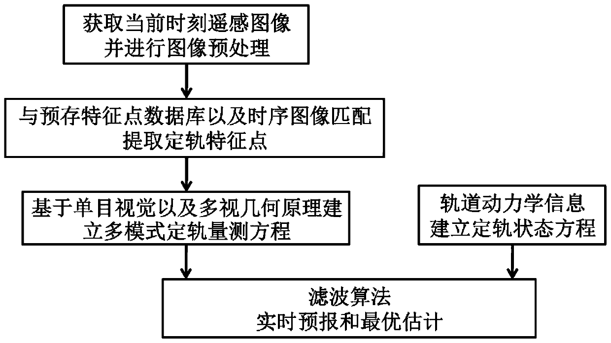
[0041] The invention is an image-based remote sensing satellite multi-mode autonomous orbit determination method, such as figure 1 shown, including the following steps:

[0042] Step 1: Obtain the remote sensing image of the remote sensing satellite at the current moment; the remote sensing image obtained in real time cannot be used directly, and the remote sensing image at the current moment needs to be preprocessed to obtain the preprocessed remote sensing image.

[0043] Wherein, the preprocessing of the remote sensing image at the current moment includes atmospheric correction, image denoising, image topographical fluctuation effect removal, image earth curvature effect removal and push-broom ...


PUM


Abstract

The invention discloses an image-based remote sensing satellite multi-mode autonomous orbit determination method. The remote sensing satellite multi-mode autonomous orbit determination method comprises the following steps of: step 1, preprocessing a remote sensing image; step 2, matching the preprocessed remote sensing image with a ground feature point library and a remote sensing image at a previous moment, and extracting orbit determination feature points; step 3, establishing a multi-mode orbit determination measurement equation based on monocular vision and multi-view geometric principles;step 4, establishing an orbit determination state equation based on an orbit dynamics model; step 5, and performing high-precision real-time optimal estimation on an orbit determination state quantity through adopting a filtering algorithm based on the orbit determination measurement equation and the orbit determination state equation. According to the remote sensing satellite multi-mode autonomous orbit determination method, the problems of poor orbital determination autonomy and low orbital determination precision of the remote sensing satellite are solved, and the multi-mode autonomous orbital determination observation model based on the image is constructed according to the monocular vision and multi-view geometric principle, so that the improvement of the precision and reliability ofautonomous orbital determination of the remote sensing satellite and the enhancement of the autonomy are realized.

Description

technical field [0001] The invention relates to the technical field of satellite orbit determination, in particular to an image-based multi-mode autonomous orbit determination method for remote sensing satellites. Background technique [0002] The continuous development of human space activities puts forward higher requirements for satellite orbit determination technology. At present, the navigation technology for satellites can be divided into three categories, ground-based navigation based on ground facilities, space-based navigation based on space navigation constellations, and autonomous navigation relying on the satellite's own load. Among these three types of technologies, ground-based and space-based navigation technologies play a vital role in various space missions today. Using the telemetry data of the ground measurement and control station or the measurement data of the GPS navigation constellation, combined with the high-precision orbit dynamics model, the orbit...

Claims


Application Information

Patent Timeline
Patent Type & Authority Applications(China)
IPC IPC(8): G01C21/24G01C11/00G06K9/62
CPCG01C21/24G01C11/00G06V10/751
Inventor 李木子孙俊谭龙玉彭杨王兆龙
Owner SHANGHAI AEROSPACE CONTROL TECH INST
Why Eureka
Try Eureka