Tile map service clustering system and method based on Redis and PostgreSQL

A tiled map and service cluster technology, applied in the field of map services, can solve problems such as data inconsistency, resource consumption, and emptying, and achieve the effects of easy operation, improved sharing, and high read and write performance

Pending Publication Date: 2020-04-28
GEOVIS CO LTD
View PDF6 Cites 2 Cited by
  • Summary
  • Abstract
  • Description
  • Claims
  • Application Information

AI Technical Summary

Problems solved by technology

[0014] Using the memory cache metadata of the service is indeed faster, but when the service is restarted, the cache will be completely cleared, and it is very time-consuming to start loading from the price asking system. It takes tens of minutes if there are many layers.
[0015] In the case of cluster deployment, a metadata sample will be saved in the memory of each instance, which consumes a lot of resources and is likely to cause data inconsistency between instances, which has certain hidden dangers

Method used


Image

  • Tile map service clustering system and method based on Redis and PostgreSQL
  • Tile map service clustering system and method based on Redis and PostgreSQL
  • Tile map service clustering system and method based on Redis and PostgreSQL

Examples


Embodiment Construction

[0044] The following will clearly and completely describe the technical solutions in the embodiments of the present invention with reference to the accompanying drawings in the embodiments of the present invention. Obviously, the described embodiments are only a part of the embodiments of the present invention, rather than all the embodiments. Based on the embodiments of the present invention, all other embodiments obtained by those of ordinary skill in the art without creative work shall fall within the protection scope of the present invention.

[0045] The present invention will be further described in detail below in conjunction with the drawings.

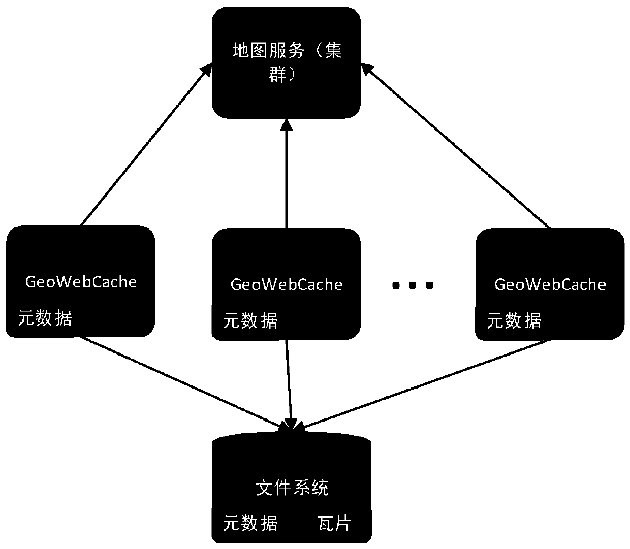
[0046] See attached Figure 1-2 As shown, it is a typical usage of GeoWebCache in the prior art. It can be seen that GeoWebCache uses its own memory and file system to store map metadata information, and uses the file system as tile cache. This method has the following problems:

[0047] The service needs to interact with the hard d...


PUM


Abstract

The invention provides a tile map service clustering system and a method based on Redis and PostgreSQL. The system comprises a remote dictionary service Redis and a PostgreSQL database server, and a tile map service cluster system stores map metadata into the PostgreSQL database server; a remote dictionary service Redis is used as cache of map metadata and tiles, and a copy of the requested tilesis reserved in the Redis service. When the client requests a tile, the server intercepts a request from the client and judges whether data of the request is cached; if the request data are cached, thecached pictures are directly rendered to the client; and if the request data is not cached, the request data are processed by the downstream of the tile map service system, obtaining the tile data, caching the tile data to a remote dictionary service Redis, drawing the tile data to a client, accessing the same tile next time, and directly obtaining the tile data through the Redis.

Description

Technical field [0001] The invention relates to the technical field of map services, in particular to a tile map service cluster system and a method for processing tile map requests. Background technique [0002] The tile map pyramid model is a multi-resolution hierarchical model. From the bottom to the top of the tile pyramid, the resolution is getting lower and lower, but the geographic scope of the representation remains unchanged. First determine the number N of zoom levels to be provided by the map service platform, take the map image with the highest zoom level and the largest map scale as the bottom layer of the pyramid, that is, the 0th layer, and divide it into blocks, starting from the upper left corner of the map image, Cut from left to right and top to bottom, and divide it into square map tiles of the same size (for example, 256×256 pixels) to form the 0th layer tile matrix; on the basis of the 0th layer map image, press every 2 ×2 pixels are synthesized into one pi...

Claims


Application Information

Patent Timeline
Patent Type & Authority Applications(China)
IPC IPC(8): G06F16/29G06F16/16G06F16/172
CPCG06F16/29G06F16/172G06F16/164
Inventor 任中奇
Owner GEOVIS CO LTD
Why Eureka
Try Eureka